
Pines
| coat of arms | Germany map | |
|---|---|---|

|
Coordinates: 49 ° 51 ' N , 6 ° 46' E |
|
| Basic data | ||
| State : | Rhineland-Palatinate | |
| County : | Trier-Saarburg | |
| Association municipality : | Schweich on the Roman Wine Route | |
| Height : | 205 m above sea level NHN | |
| Area : | 9.79 km 2 | |
| Residents: | 2906 (Dec. 31, 2019) | |
| Population density : | 297 inhabitants per km 2 | |
| Postal code : | 54343 | |
| Area code : | 06502 | |
| License plate : | TR, SAB | |
| Community key : | 07 2 35 026 | |
| Association administration address: | Brückenstrasse 26 54338 Schweich |
|
| Website : | ||
| Mayoress : | Rosi Radant ( CDU ) | |
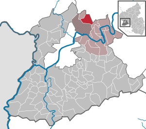
| Location of the local community Föhren in the district of Trier-Saarburg | ||
  |
||


Föhren am Meulenwald is a municipality in the Trier-Saarburg district in Rhineland-Palatinate . It belongs to the Verbandsgemeinde Schweich on the Roman Wine Route and is the largest municipality after the city of Schweich . The Trier-Föhren airport is located in Föhren .
geography
Föhren lies in the area of the Wittlich depression and is bounded to the southeast by the "Föhrener Heide" (Föhren airfield) and to the northwest by the Meulenwald.
The Hochkreuz and Terneshof residential areas also belong to Föhren .
politics
Municipal council
The local council in Föhren consists of 20 council members, who were elected in a personalized proportional representation in the local elections on May 26, 2019 , and the honorary local mayor as chairman.
The distribution of seats in the local council:
| choice | SPD | CDU | WGR | total |
|---|---|---|---|---|
| 2019 | 7th | 9 | 4th | 20 seats |
| 2014 | 7th | 7th | 6th | 20 seats |
| 2009 | 8th | 6th | 6th | 20 seats |
| 2004 | 9 | 7th | 4th | 20 seats |
mayor
In 2014, Rosi Radant (CDU) was elected as the successor to Jürgen Reinehr (SPD) as the new local mayor. She was re-elected in 2019.
coat of arms
|
|
Blazon : “Shield with a curved, lowered golden tip, inside a red furnace with a silver furnace hole, split; in front a golden book in blue, covered with a black high cross, behind in silver a red dragon. " |
| Justification for the coat of arms: The golden book is an attribute of the local church patron St. Bartholomäus . It is handed down in a “Sigill Paroche Eccl. S. Bartholomäi ”(printed in 1787 in the Trier diocese archive). The red dragon is the family coat of arms of the imperial counts of Kesselstatt , who were local lords of Föhren from 1446 until the Napoleonic period as feudal people of the Electors of Trier . The kiln is a speaking sign ; the place name "Föhren" derives from the Roman expression "Furnus" = kiln (for pottery) or melting furnace (for turf ore or copper). |
Attractions
- Föhren Castle
- Catholic parish church of St. Bartholomew
- Tithe barn
- "Fat Lord"
- Local history museum and "Alte Backscheier"
- Viezkelterstation
- Tomb of Primulus
- Solar power plant IRT (8.4 MW peak output)
See also: List of cultural monuments in Föhren
Events
Every year on the penultimate weekend in August, the Bartholomäus fair takes place in Föhren. The fair extends over four days from Friday to Monday.
Economy and Transport
The Trier industrial park is located between Föhren and Hetzerath (Eifel) .
Föhren has its own junction (# 128) on the A 1 .
In addition, the Föhren train stop is on the Moselle route (Koblenz – Trier).
It is served by the following lines:
| line | designation | Train run | Clock frequency |
|---|---|---|---|
| RE 1 | Southwest Express | Koblenz - Cochem - Bullay (DB) - Wittlich - Föhren - Trier - Saarlouis - Völklingen - Saarbrücken - Homburg - Kaiserslautern | one train Mon - Sat |
| RE 11 | DeLux-Express | Koblenz - Cochem - Bullay (DB) - Wittlich - Föhren - Trier - Wasserbillig - Sandweiler-Contern - Luxembourg | one train Mon - Fri |
| RB 81 | Moselle Valley Railway | Koblenz - Cochem - Bullay (DB) - Wittlich - Föhren - Trier | 60 min |
| RB 81 | Elbling Railway | Wittlich - Föhren - Trier - Konz Mitte - Wellen - Perl | individual trains |
| RB 83 | Elbling Railway | Wittlich - Föhren - Trier - Wasserbillig - Munsbach - Wecker - Sandweiler-Contern - Luxembourg | 60 min Mon - Sat |
Lines RE 1 and RE 11 run between Koblenz and Trier in double traction and are winged in Trier . The RE 11 does not begin until Trier on Saturdays.
Personalities
- Jan Thielmann (* 2002), soccer player
Web links
- Website of the municipality of Föhren
- Föhren Castle (Kesselstatt)
- Link catalog on the subject of pine at curlie.org (formerly DMOZ )
Individual evidence
- ↑ State Statistical Office of Rhineland-Palatinate - population status 2019, districts, communities, association communities ( help on this ).
- ↑ State Statistical Office Rhineland-Palatinate (ed.): Official directory of the municipalities and parts of the municipality. Status: January 2019 [ Version 2020 is available. ] . S. 120 (PDF; 3 MB).
- ^ The Regional Returning Officer Rhineland-Palatinate: Local elections 2019, city and municipal council elections

Aach | Ayl | Baldringen | Bekond | Notification | Beuren (high forest) | Bonerath | Damflos | Detzem | Ensch | Farschweiler | Fur | Fish | Pine | Franzenheim | Freudenburg | Geisfeld | Greimerath | Grimburg | Gusenburg | Gusterath | Gutweiler | Heddert | Stalling | Herl | Hermeskeil | Hinzenburg | Hinzert-Pölert | Hockweiler | Holzerath | Hedgehog | Irsch | Kanzem | Chasuble | Kastel-Staadt | Kell am See | Kenn | Kirf | Klüsserath | Conc | Cord | Korlingen | Köwerich | Lampades | Langsur | Leiwen | Lunge | Longuich | Lorscheid | Mandern | Mannebach | Mehring | Mertesdorf | Merzkirchen | Morscheid | Naurath (Eifel) | Naurath (forest) | Neuhütten | Newel | Nittel | Upper cheap | Ockfen | Ollmuth | Onsdorf | Osburg | Palzem | Paschel | Pellingen | Pluwig | Pölich | Ralingen | Swift oath | Reinsfeld | Riol | Riveris | Saarburg | Schillings | Schleich | Schoden | Schömerich | Schondorf | Schweich | Serrig | Sommerau | Taben-Rodt | Tawern | Temmels | Thomm | Thörnich | Trassem | Trierweiler | Trittenheim | Vierherrenborn | Waldrach | Waldweiler | Wasserliesch | Wawern | Waves | Welschbillig | Wiltingen | Wincheringen | Zemmer | Zerf | Züsch