
Waldrach
| coat of arms | Germany map | |
|---|---|---|

|
Coordinates: 49 ° 45 ' N , 6 ° 45' E |
|
| Basic data | ||
| State : | Rhineland-Palatinate | |
| County : | Trier-Saarburg | |
| Association municipality : | Ruwer | |
| Height : | 159 m above sea level NHN | |
| Area : | 12.46 km 2 | |
| Residents: | 2024 (Dec. 31, 2019) | |
| Population density : | 162 inhabitants per km 2 | |
| Postal code : | 54320 | |
| Area code : | 06500 | |
| License plate : | TR, SAB | |
| Community key : | 07 2 35 141 | |
| Association administration address: | Untere Kirchstrasse 1 54320 Waldrach |
|
| Website : | ||
| Local Mayor : | Rainer Krämer ( CDU ) | |
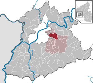
| Location of the local community Waldrach in the district of Trier-Saarburg | ||
  |
||


Waldrach ( Moselle Franconian : Waldrisch ) is a municipality in the Trier-Saarburg district in Rhineland-Palatinate . It is the administrative seat of the Verbandsgemeinde Ruwer , to which it also belongs. Waldrach is a state-approved resort and designated as a basic center according to state planning .
geography
The wine village is in the Ruwertal . Waldrach also includes the Kampf, Schleifmühle and Schmelzmühle residential areas .
Surrounding places are Kasel , Fell , Thomm , Osburg , Riveris , Morscheid and Trier-Tarforst .
To the left of the Ruwer is the striking Naumeter Kupp , which belongs to Trier-Tarforst. On the other side of the valley are the highest elevations in the district with the Hochbüschkopf (408 m), Ginner (423 m), Biedelt (426 m) and the Läusberg (427 m). As Waldracher mountain is called the section of the national road 149 from the exit Waldrach to Hinkelhaus in Thomm, which has a length of about 5 km and a vertical drop of over 200 meters.
In addition to Ruwer and Riveris, rivers in the municipality are the left Ruwer tributaries Fuchsbach, Wolfsbach, Latschbach and Benninger Bach , the right Riveris tributaries Bausbach (with Rotelbach ) and Schupperterbach and the right Ruwer tributaries Mörtschelbach and Kehrnagelbach. In the north-east of the district, the brook from the Ginner, the Schraubelsbach and the Rilpesbach flow over the Nossernbach to the Fellerbach and the Moselle . Very small areas drain there to the Longuicher Bach (Moselle) and the Frievelsbach (Fellerbach).
history
The settlement of the Trier region, which was probably only sporadic at the time of the Celts , experienced an enormous upswing with the conquest and possession by the Romans . With the end of the armed conflict, more and more Roman farms and villas emerged in the countryside, and from many of these there were village settlements, especially in the valleys of the Moselle , Saar and Ruwer , where viticulture spread. The most famous vineyard is the Waldracher Krone. The Viez is also made in the area.
The wine village of Waldrach, located in the lower Ruwertal, with a district size of around 1,200 hectares, including around 70 hectares of vineyards, can look back on almost 2,000 years of history. Remains of Roman settlements were found in the area of the parish church, the grinding mill (marble grinding mill, according to Ausonius ), in Zalzick and in St. Liepert ( Roman court estate ). A little above the grinding mill was the inlet or the beginning of the Roman aqueduct , fed by the Ruwer water , which led through a closed canal and supplied the Roman city of Trier with water. A replica of the cross-section of this Roman aqueduct is located on the southern outskirts at a parking lot on Kreisstraße 12 . Remains of the original of the Roman aqueduct can be seen in the area of the former train station.
The spelling of the place name has been changed several times over the centuries. "Valeriacum" is the place in documents of Charlemagne (802) and Otto the Great (949). Probably derived from the name " Valerius ", one of the three first bishops in Trier. Since the Eckbert document from 981 - in which the parish church is mentioned for the first time - the place has been called Waltrach (1200 Waltracha, 1212 Waltrache, 1255 Waltrachen, 1323 Waltraco, 1411 Valtrich, 1646 Waltrich) and from 1841 for the first time Waldrach.
The tower of the Catholic parish church of St. Laurentius dates back to the 12th century. The parish church in its current form was built in 1904/05. When the US armed forces took the place in February 1945, they set fire to the roof structure of the church with targeted fire, as it was suspected that there was an observation post for the Volkssturm in the church tower. However, this assumption turned out to be wrong, as the Volkssturm had already moved to Fell at this point . The roof structure burned out completely from the fire. After the end of the war, the church was extensively restored and modernized in the early 1980s. Further renovations took place before the church's 100th anniversary in 2005.
The St. Laurentius elementary and secondary school, opened in 1967, was a central school, later a regional school and from 2009/2010 a secondary school plus for the surrounding local communities.
In 1985 Mechthild Meyer (later Weis) from Waldrach became German Wine Queen . The "Square of our German Wine Queen" (formerly Untere Kirchstrasse 1, later relocated to the south-west edge of the community) was named after this event.
To commemorate the Jewish victims of National Socialism in Waldrach, six stumbling blocks were laid by the artist Gunter Demnig in 2007 , see also the list of stumbling blocks in Waldrach .
In 2014, the new Waldrach family center was completed on the community square. It includes rooms for the St. Laurentius daycare center, a citizens' hall and a youth room. In September 2017, Kathrin Hegner from Waldrach was elected as the new Moselle wine queen.
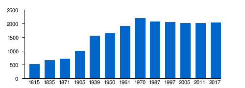
Population development
The development of the population of Waldrach, the values from 1871 to 1987 are based on censuses:
|
|
Graphic of the population development
|
On December 31, 2015 there were 2,098 main and secondary residences in Waldrach and on December 31, 2017 there were 2,130.
politics
Since November 1, 2005, Waldrach has been the seat of the Ruwer community administration with a newly built town hall at Unteren Kirchstrasse 1.
Municipal council
The local council in Waldrach consists of 16 council members, who were elected in the local elections on May 26, 2019 in a personalized proportional representation, and the honorary local mayor as chairman.
The distribution of seats in the local council:
| choice | SPD | CDU | FWG | total |
|---|---|---|---|---|
| 2019 | 4th | 8th | 4th | 16 seats |
| 2014 | 3 | 9 | 4th | 16 seats |
| 2009 | 3 | 9 | 4th | 16 seats |
| 2004 | 3 | 8th | 5 | 16 seats |
- FWG = Free Voter Group Waldrach e. V.
Local mayor
- Johann Bales, 1964 to 1989
- Heinfried Carduck, 1989 to 2019
- Rainer Krämer, from 2019
coat of arms
|
|
Blazon : “The shield is divided and split at the top. At the top right a red bar cross in silver. At the top left, an oblique left silver wavy band in green, accompanied on both sides by a golden fir tree. Below in gold a green vine with three green leaves and two green grapes. " |
| Reasons for the coat of arms: The red cross in silver is the heraldic symbol of the Archdiocese and Electorate of Trier , to which Waldrach belonged from the Middle Ages to the secularization. The silver wavy band marks the Ruwer . The fir trees “ speaking ” refer to the term “forest” in the place name. The vine is a reminder that Waldrach is the largest wine-growing community on the Ruwer. |
Culture and sights
Parts of the Roman Ruwer water pipeline in the area of the former train station as well as a replica of the Ruwer water pipeline above the village on the Roman road are worth seeing .
- Sports
For 10 years (as of 2020) there has been an approximately one kilometer long downhill mountain bike trail in Waldrach above the forest path, the so-called Gotterhüttentrail (also called Gotterhüttentrail ).
- See also
Economy and Infrastructure
Agriculture, forestry, viticulture
The ground area in Waldrach has a size of 12.46 km². This includes:
- Agricultural land 37.9%
- Forest areas 48.1%
- Water surface 0.4%
- Settlement and traffic areas 13.5%
- Other areas 0.1%
The vineyards are Heiligenhäuschen, Hubertusberg, Sonnenberg, Jungfernberg, Krone, Laurentiusberg, Ehrenberg, Doktorberg, Meisenberg, Jesuitengarten and Kurfürstenberg.
Viticulture , which dominated the landscape up until the 1980s, is now in decline, as can be clearly seen from the abandoned cultivation areas. The reason for this is u. a. the decreasing number of part-time winemakers, for whom viticulture no longer offers any financial incentives due to the high personal and material requirements of the management of steep slopes and the low producer prices.
Waldrach is known for its Douglas fir stocks . There are around 15 hectares of Douglas fir forest in the Waldrach forest district.
Companies
Waldrach has some commercial and craft businesses as well as branches of the Sparkasse Trier , Volksbank Trier and Postbank . There is an industrial area between Waldrach and Kasel . In 2011, a Wasgau supermarket moved into a newly built supermarket there; A Norma branch opened in the previous building in October 2015 . The largest employers are the school and the municipal administration. In recent years, tourism has been given increasing importance.
A community wind farm with ten wind turbines is located above Waldrach on Landesstrasse 151 .
media
Local media are the Trierische Volksfreund , the Mosel-Ruwertaler Wochenspiegel and the official gazette of the Verbandsgemeinde Ruwer.
Public facilities
Public facilities in Waldrach are the library , the family center , the fire brigade , the youth center , the kindergarten , the parish church of St. Laurentius , the town hall , the school , the social station with care support point , the central sports facility , the tennis facility , the adult education center and the hunting association . The Dr. Joseph Hammes Park is located at the entrance to Waldrach between Trierer Strasse and Ruwer.
traffic
Landesstraße 151 (formerly Bundesstraße 52 ) runs through the municipality of Waldrach, while Landesstraße 149 runs through Trierer Straße, Bahnhofstraße and Hermeskeiler Straße .
Local public transport : Waldrach is connected to the city of Trier's bus network as well as to the rural line R200 / 202 (( Türkismühle -) Hermeskeil - Trier ).
From 1889 to 1998 the Hochwaldbahn ran through Waldrach. Today the Ruwer-Hochwald-Radweg runs there .
Personalities
- Paul Linz (* 1956), soccer coach and former soccer player
photos
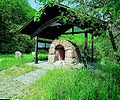
Roman aqueduct - replica -

school-building

Fire station and social station Waldrach

Town hall VG Ruwer

Place of "our" German wine queen

old trainstation
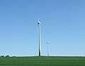
Wind turbines near Waldrach


Literary processing
The landscape of the Ruwertal is described in the Ruwertallied .
Web links
- Website of the local community Waldrach
- Link catalog on Waldrach at curlie.org (formerly DMOZ )
- To search for cultural assets of the local community Waldrach in the database of cultural assets in the Trier region .
Individual evidence
- ↑ State Statistical Office of Rhineland-Palatinate - population status 2019, districts, communities, association communities ( help on this ).
- ↑ a b State Statistical Office Rhineland-Palatinate: Regional data.
- ↑ State Statistical Office Rhineland-Palatinate (ed.): Official directory of the municipalities and parts of the municipality. Status: January 2019 [ Version 2020 is available. ] . S. 120 (PDF; 3 MB).
- ↑ ewois.de
- ^ The Regional Returning Officer Rhineland-Palatinate: Local elections, city and municipal council elections
- ↑ https://www.komoot.de/highlight/88889 Götterhüttentrail near Waldrach
- ↑ Second Invest-Wind Waldrach GmbH & Co. KG

Aach | Ayl | Baldringen | Bekond | Notification | Beuren (high forest) | Bonerath | Damflos | Detzem | Ensch | Farschweiler | Fur | Fish | Pine | Franzenheim | Freudenburg | Geisfeld | Greimerath | Grimburg | Gusenburg | Gusterath | Gutweiler | Heddert | Stalling | Herl | Hermeskeil | Hinzenburg | Hinzert-Pölert | Hockweiler | Holzerath | Hedgehog | Irsch | Kanzem | Chasuble | Kastel-Staadt | Kell am See | Kenn | Kirf | Klüsserath | Conc | Cord | Korlingen | Köwerich | Lampades | Langsur | Leiwen | Lunge | Longuich | Lorscheid | Mandern | Mannebach | Mehring | Mertesdorf | Merzkirchen | Morscheid | Naurath (Eifel) | Naurath (forest) | Neuhütten | Newel | Nittel | Upper cheap | Ockfen | Ollmuth | Onsdorf | Osburg | Palzem | Paschel | Pellingen | Pluwig | Pölich | Ralingen | Swift oath | Reinsfeld | Riol | Riveris | Saarburg | Schillings | Schleich | Schoden | Schömerich | Schondorf | Schweich | Serrig | Sommerau | Taben-Rodt | Tawern | Temmels | Thomm | Thörnich | Trassem | Trierweiler | Trittenheim | Vierherrenborn | Waldrach | Waldweiler | Wasserliesch | Wawern | Waves | Welschbillig | Wiltingen | Wincheringen | Zemmer | Zerf | Züsch