
Gusterath
| coat of arms | Germany map | |
|---|---|---|

|
Coordinates: 49 ° 42 ' N , 6 ° 43' E |
|
| Basic data | ||
| State : | Rhineland-Palatinate | |
| County : | Trier-Saarburg | |
| Association municipality : | Ruwer | |
| Height : | 301 m above sea level NHN | |
| Area : | 4.41 km 2 | |
| Residents: | 2025 (Dec. 31, 2019) | |
| Population density : | 459 inhabitants per km 2 | |
| Postal code : | 54317 | |
| Area code : | 06588 | |
| License plate : | TR, SAB | |
| Community key : | 07 2 35 037 | |
| Association administration address: | Untere Kirchstrasse 1 54320 Waldrach |
|
| Website : | ||
| Local Mayor : | Stefan Metzdorf ( SPD ) | |
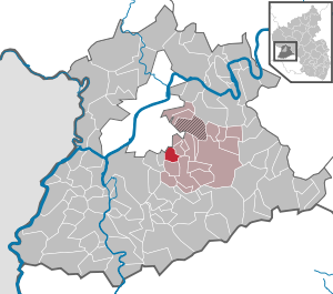
| Location of the local community of Gusterath in the Trier-Saarburg district | ||
  |
||

Gusterath ( Moselle-Franconian : Göstert ) is a municipality in the Trier-Saarburg district in Rhineland-Palatinate . It belongs to the Verbandsgemeinde Ruwer , which has its administrative headquarters in Waldrach .
geography

.jpg)

Gusterath is located in the middle Ruwertal near Trier .
history
Individual farmsteads already existed in Roman times, which is proven by finds of Roman building rubble in the linden cross and Im Schiffelland fields. The place is mentioned for the first time as Gozprethrode in a document from the year 1236 in connection with the donation of the rule and usage rights over the church in Gusterath to the nunnery St. Martin auf dem Berge . In 1246 the current desert on the Ruwer is called Nivenderoth . A church that was dilapidated in 1670 was replaced by a new building in 1797 and restored in 1881/82.
politics
Local mayor
- Günter Scherer, SPD
- until 2019: Alfred Bläser, FWG
- from 2019: Stefan Metzdorf, SPD
coat of arms
|
|
Blazon : "Coat of arms divided, split below, above in gold a growing red lion, below in front a red cross in silver, in the back a golden shoe in blue." |
| Justification for the coat of arms: The red lion in gold and the blue are taken from the coat of arms of Wilhelm von Helphenstein . The von Helphenstein family had the right of patronage over the place. In 1236 Archbishop Theoderich von Trier confirmed the ownership of the patronage right to the monastery of St. Martin on the mountain of Trier. The Helphenstein seal is attached to this certificate. The Kurtrier Cross indicates that the place belonged to the Electorate of Trier for centuries. The shoe symbolizes the economic importance of the shoe industry ( Romika ) for the community over the past 50 years. |
Economy and Infrastructure
The Gusterath-Tal industrial park is located near Gusterath . The Romika shoe production facility used to be located there , which provided a large part of the jobs in the Ruwertal area until the 1980s.
Public institutions are the Gusterath-Pluwig elementary school, a day-care center, a community center, a barbecue hut in the adjacent forest and a sports facility. Gusterath is located on the Romika-Weg premium hiking trail .

media
Local media are the Trierische Volksfreund , the Wochenspiegel and the official gazette of the Verbandsgemeinde Ruwer.
See also
Web links
- Website of the local community Gusterath
- To search for cultural goods of the local community Gusterath in the database of cultural goods in the Trier region .
- Link catalog on the topic of Gusterath at curlie.org (formerly DMOZ )
Individual evidence
- ↑ State Statistical Office of Rhineland-Palatinate - population status 2019, districts, communities, association communities ( help on this ).

Aach | Ayl | Baldringen | Bekond | Notification | Beuren (high forest) | Bonerath | Damflos | Detzem | Ensch | Farschweiler | Fur | Fish | Pine | Franzenheim | Freudenburg | Geisfeld | Greimerath | Grimburg | Gusenburg | Gusterath | Gutweiler | Heddert | Stalling | Herl | Hermeskeil | Hinzenburg | Hinzert-Pölert | Hockweiler | Holzerath | Hedgehog | Irsch | Kanzem | Chasuble | Kastel-Staadt | Kell am See | Kenn | Kirf | Klüsserath | Conc | Cord | Korlingen | Köwerich | Lampades | Langsur | Leiwen | Lunge | Longuich | Lorscheid | Mandern | Mannebach | Mehring | Mertesdorf | Merzkirchen | Morscheid | Naurath (Eifel) | Naurath (forest) | Neuhütten | Newel | Nittel | Upper cheap | Ockfen | Ollmuth | Onsdorf | Osburg | Palzem | Paschel | Pellingen | Pluwig | Pölich | Ralingen | Swift oath | Reinsfeld | Riol | Riveris | Saarburg | Schillings | Schleich | Schoden | Schömerich | Schondorf | Schweich | Serrig | Sommerau | Taben-Rodt | Tawern | Temmels | Thomm | Thörnich | Trassem | Trierweiler | Trittenheim | Vierherrenborn | Waldrach | Waldweiler | Wasserliesch | Wawern | Waves | Welschbillig | Wiltingen | Wincheringen | Zemmer | Zerf | Züsch