
Mannebach (near Saarburg)
| coat of arms | Germany map | |
|---|---|---|

|
Coordinates: 49 ° 38 ' N , 6 ° 31' E |
|
| Basic data | ||
| State : | Rhineland-Palatinate | |
| County : | Trier-Saarburg | |
| Association municipality : | Saarburg-Kell | |
| Height : | 250 m above sea level NHN | |
| Area : | 6.03 km 2 | |
| Residents: | 328 (Dec. 31, 2019) | |
| Population density : | 54 inhabitants per km 2 | |
| Postal code : | 54441 | |
| Area code : | 06581 | |
| License plate : | TR, SAB | |
| Community key : | 07 2 35 082 | |
| Association administration address: | Schloßberg 6 54439 Saarburg |
|
| Website : | ||
| Local Mayor : | Thomas Lellig | |
| Location of the local community Mannebach in the district of Trier-Saarburg | ||
  |
||

Mannebach is a municipality in the Trier-Saarburg district in Rhineland-Palatinate . It belongs to the Saarburg-Kell association.
geography
The local community of Mannebach is a village on the creek of the same name with the district of Kümmern on the upper mountain slope. The place is still largely characterized by agriculture and the landscape of the Saargau .
history
Historically, Stone Age settlement and workplaces are worth mentioning. Due to the immediate location on the Roman road Trier-Metz, traces of Roman settlement can also be proven.
On July 18, 1946, Mannebach, together with 80 other municipalities in the districts of Trier and Saarburg , was incorporated into the Saar area , which was separated from the rest of the French occupation zone in February 1946 and which was no longer under the Allied Control Council at the time . On June 6, 1947, this territorial outsourcing was withdrawn to 21 communities, so Mannebach came to the 1946 newly formed state of Rhineland-Palatinate .
Municipal council
The local council in Mannebach consists of eight council members who were elected by a majority vote in the local elections on May 26, 2019 , and the honorary local mayor as chairman.
Buildings
The restored Catholic parish church of St. Anna, which towers above the town, was built in 1852/53 by the builder Alexius Faure from Saarburg.
Infrastructure
Surrounded by a landscape of forests, meadows and floodplains, the place offers residents and visitors a variety of opportunities for hiking and relaxation. For cyclists, Mannebach can be reached from the direction of Konz / Tawern via a cycle path that has been developed in the Bachtal and on the edge of the forest. Mannebach is located directly on the historic Jakobus pilgrimage route to Santiago de Compostela and is connected to Viezstraße .
In the village there is the Mannebacher brewery with inn, beer garden and hotel.
The municipality of Mannebach has a community center with a youth room, a lawn sports facility, two children's playgrounds and a barbecue hut that can be rented out for events.

Location Mannebach

Location Mannebach, in the background the district Kümmern

Catholic parish church St. Anna, Mannebach

Wayside cross (1838), Schulstr. 2

Crossroads (1777) in the meadow path
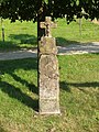
Crossroads on the K112

Crossroads at the corner of Hauptstraße / Wiesenweg
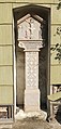
Wayside shrine (1653) in Kümmern


.jpg)


See also
literature
- Ernst Wackenroder : The art monuments of the Saarburg district . (= Paul Clemen (Hrsg.): Die Kunstdenkmäler der Rheinprovinz , Volume 15, III. Department). L. Schwann, Düsseldorf 1939 (reprint published by the Academic Bookshop Interbook, Trier 1982), pp. 134-136.
Web links
- To search for cultural assets of the local community Mannebach (near Saarburg) in the database of cultural assets in the Trier region .
- Link catalog on Mannebach at curlie.org (formerly DMOZ )
Individual evidence
- ↑ State Statistical Office of Rhineland-Palatinate - population status 2019, districts, communities, association communities ( help on this ).
- ^ The Regional Returning Officer Rhineland-Palatinate: Local elections 2019, city and municipal council elections

Aach | Ayl | Baldringen | Bekond | Notification | Beuren (high forest) | Bonerath | Damflos | Detzem | Ensch | Farschweiler | Fur | Fish | Pine | Franzenheim | Freudenburg | Geisfeld | Greimerath | Grimburg | Gusenburg | Gusterath | Gutweiler | Heddert | Stalling | Herl | Hermeskeil | Hinzenburg | Hinzert-Pölert | Hockweiler | Holzerath | Hedgehog | Irsch | Kanzem | Chasuble | Kastel-Staadt | Kell am See | Kenn | Kirf | Klüsserath | Conc | Cord | Korlingen | Köwerich | Lampades | Langsur | Leiwen | Lunge | Longuich | Lorscheid | Mandern | Mannebach | Mehring | Mertesdorf | Merzkirchen | Morscheid | Naurath (Eifel) | Naurath (forest) | Neuhütten | Newel | Nittel | Upper cheap | Ockfen | Ollmuth | Onsdorf | Osburg | Palzem | Paschel | Pellingen | Pluwig | Pölich | Ralingen | Swift oath | Reinsfeld | Riol | Riveris | Saarburg | Schillings | Schleich | Schoden | Schömerich | Schondorf | Schweich | Serrig | Sommerau | Taben-Rodt | Tawern | Temmels | Thomm | Thörnich | Trassem | Trierweiler | Trittenheim | Vierherrenborn | Waldrach | Waldweiler | Wasserliesch | Wawern | Waves | Welschbillig | Wiltingen | Wincheringen | Zemmer | Zerf | Züsch