
Wincheringen
| coat of arms | Germany map | |
|---|---|---|

|
Coordinates: 49 ° 36 ' N , 6 ° 25' E |
|
| Basic data | ||
| State : | Rhineland-Palatinate | |
| County : | Trier-Saarburg | |
| Association municipality : | Saarburg-Kell | |
| Height : | 240 m above sea level NHN | |
| Area : | 18.73 km 2 | |
| Residents: | 2276 (Dec. 31, 2019) | |
| Population density : | 122 inhabitants per km 2 | |
| Postal code : | 54457 | |
| Area code : | 06583 | |
| License plate : | TR, SAB | |
| Community key : | 07 2 35 149 | |
| LOCODE : | DE WN4 | |
| Community structure: | 3 districts | |
| Association administration address: | Schloßberg 6 54439 Saarburg |
|
| Website : | ||
| Local Mayor : | Elmar Schömann | |
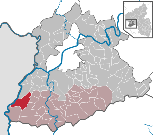
| Location of the local community Wincheringen in the district of Trier-Saarburg | ||
  |
||

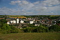
Wincheringen is a municipality in the Trier-Saarburg district in Rhineland-Palatinate . It belongs to the Saarburg-Kell association. Wincheringen is designated as a basic center according to state planning .
Geographical location
Wincheringen is located on the German-French-Luxembourgish Upper Moselle .
Districts are Wincheringen, Bilzingen and Söst.
history
The place was first mentioned under the name Winegringen in 893 in the Prümer Urbar .
The landmark of the village, the Warsberghaus with the former defense tower, originates from the 11th / 12th. Century. It belonged to a moated castle that was destroyed over the centuries except for the manor house and the defense tower. The house takes its name from the Warsberg family , who found their way from Varsberg in Lorraine to the Upper Moselle. From 1473 to 1793 they decisively determined the history of the place and the region. Today the tower and house are owned by the community. A curiosity is that the bells of the nearby parish church “St. Peter ”in the tower of the civil parish. After the former Warsberg tower became the property of the municipality in 1830, it served as the bell tower of the parish church at that time, which was located in the immediate vicinity of today's cemetery. The new church, consecrated in 1884, was built according to the plans of the architect Reinhold Wirtz without a bell tower. A small tower with a bell was used to indicate the change during the mass. The church was destroyed on October 6, 1944, when the entire church roof burned out.
Today's district of Wincheringen was the eponymous capital of the Wincheringen rule, which belonged to the duchy of Luxembourg as a sovereign , until the end of the 18th century . The Wincheringen lordship also included the village of Fisch with Littorf and part of Rehlingen (now part of Nittel ), part of the village of Körrig (now part of Merzkirchen ), the Rohlingen farm near Palzem and the village of Wehr (now part of Palzem). The two districts of Bilzingen and Söst, on the other hand, belonged to the electorate of Trier and were part of the Saarburg office .
As a result of the occupation of the region by French revolutionary troops , the town of Wincheringen belonged to the canton Grevenmacher in the department of forests from 1795 to 1814 . From 1798 to 1814, Bilzingen and Söst belonged to the Saarburg canton in the Saar department .
Based on the agreements made at the Congress of Vienna , the region was assigned to the Kingdom of Prussia . Under the Prussian administration, the communities of Wincheringen, Bilzingen and Söst came to the Saarburg district in the Trier administrative district , which from 1822 belonged to the Rhine province . The municipality of Wincheringen was assigned to the Nittel mayor , Bilzingen to the Meurich mayor and Söst to the Saarburg mayor .
On July 18, 1946, Wincheringen and 80 other municipalities in the districts of Trier and Saarburg were annexed to the Saar area , which was separated from the rest of the French occupation zone in February 1946 and which was no longer subject to the Allied Control Council at the time . On June 6, 1947, this territorial outsourcing was withdrawn to 21 municipalities, so Wincheringen came to the 1946 newly formed state of Rhineland-Palatinate .
On March 17, 1974, the two previously independent communities of Bilzingen (135 inhabitants) and Söst (150 inhabitants) were incorporated.
Bilzingen, located on the fertile plateau of the Saargau, once crossed a Roman road between Trier and Metz. Söst, which is embedded agriculturally between fields and meadows, can boast coin finds from Constantinian times and Franconian grave fields.
- Population development
The development of the population of Wincheringen in relation to today's municipality; the values from 1871 to 1987 are based on censuses:
|
|
politics
Municipal council
The local council in Wincheringen consists of 16 council members, who were elected in a personalized proportional representation in the local elections on May 26, 2019 , and the honorary local mayor as chairman.
The distribution of seats in the local council:
| choice | SPD | CDU | GREEN | W 21 | total |
|---|---|---|---|---|---|
| 2019 | 4th | - | - | 12 | 16 seats |
| 2014 | 4th | - | 2 | 10 | 16 seats |
| 2009 | 5 | - | - | 11 | 16 seats |
| 2004 | 4th | 12 | - | - | 16 seats |
- W 21 = voter group Wincheringen 21 e. V.
coat of arms
|
|
Blazon : “In the split shield in front in silver a continuous red cross. In the back a silver, gold-crowned, red-armored lion in black. " |
| Justification of the coat of arms: Because the place was part of the Electorate of Trier , the coat of arms shows the Electorate of Trier cross , plus the coat of arms of the von Warsberg family , who had the castle as a Trier fiefdom . |
Attractions
The Warsberghaus , the former Warsberg moated castle, Wincheringen Castle .

Wincheringen Castle (fortified tower and manor house)

Castle complex in Wincheringen / Mosel

Catholic parish church St. Peter in Wincheringen
Location Wincheringen

Söst district

Catholic branch church St. Bernhard in the district of Söst

Helenenkreuz near the district of Bilzingen


Viticulture
Wincheringen is part of the "Upper Moselle wine-growing area" in the Moselle region . 38 wine-growing businesses are active in the village, the area under vines is 103 hectares. About 97% of the wine grown are white grape varieties (as of 2007). In 1979, 112 farms were still active and the vineyard area was 114 hectares.
Personalities
- Reinhold Wirtz (1842–1898), architect, local district and diocesan master builder for the Diocese of Trier
literature
- Ernst Wackenroder : The art monuments of the Saarburg district . (= Paul Clemen (Hrsg.): Die Kunstdenkmäler der Rheinprovinz , Volume 15, III. Department). L. Schwann, Düsseldorf 1939 (reprint from the Academic Bookshop Interbook, Trier 1982), pp. 286–292.
Web links
- Short portrait of Wincheringen ( memento from February 12, 2013 in the web archive archive.today ) at Hierzuland , SWR television
- To search for cultural assets of the local community Wincheringen in the database of cultural assets in the Trier region .
- Link catalog on the subject of Wincheringen at curlie.org (formerly DMOZ )
Individual evidence
- ↑ State Statistical Office of Rhineland-Palatinate - population status 2019, districts, communities, association communities ( help on this ).
- ↑ a b c State Statistical Office Rhineland-Palatinate: My village, my city. Retrieved August 1, 2019 .
- ↑ State Statistical Office Rhineland-Palatinate (ed.): Official directory of the municipalities and parts of the municipality. Status: January 2019 [ Version 2020 is available. ] . S. 126 (PDF; 3 MB).
- ^ Georg Bärsch : Description of the government district of Trier , Volume 2, Trier, Lintz, 1846, pp. 91, 93, 96 ( Google Books )
- ↑ Official municipality directory 2006 ( Memento from December 22, 2017 in the Internet Archive ) (= State Statistical Office Rhineland-Palatinate [Hrsg.]: Statistical volumes . Volume 393 ). Bad Ems March 2006, p. 200 (PDF; 2.6 MB). Info: An up-to-date directory ( 2016 ) is available, but in the section "Territorial changes - Territorial administrative reform" it does not give any population figures.
- ^ The Regional Returning Officer Rhineland-Palatinate: Local elections 2019, city and municipal council elections. Retrieved August 1, 2019 .

Aach | Ayl | Baldringen | Bekond | Notification | Beuren (high forest) | Bonerath | Damflos | Detzem | Ensch | Farschweiler | Fur | Fish | Pine | Franzenheim | Freudenburg | Geisfeld | Greimerath | Grimburg | Gusenburg | Gusterath | Gutweiler | Heddert | Stalling | Herl | Hermeskeil | Hinzenburg | Hinzert-Pölert | Hockweiler | Holzerath | Hedgehog | Irsch | Kanzem | Chasuble | Kastel-Staadt | Kell am See | Kenn | Kirf | Klüsserath | Conc | Cord | Korlingen | Köwerich | Lampades | Langsur | Leiwen | Lunge | Longuich | Lorscheid | Mandern | Mannebach | Mehring | Mertesdorf | Merzkirchen | Morscheid | Naurath (Eifel) | Naurath (forest) | Neuhütten | Newel | Nittel | Upper cheap | Ockfen | Ollmuth | Onsdorf | Osburg | Palzem | Paschel | Pellingen | Pluwig | Pölich | Ralingen | Swift oath | Reinsfeld | Riol | Riveris | Saarburg | Schillings | Schleich | Schoden | Schömerich | Schondorf | Schweich | Serrig | Sommerau | Taben-Rodt | Tawern | Temmels | Thomm | Thörnich | Trassem | Trierweiler | Trittenheim | Vierherrenborn | Waldrach | Waldweiler | Wasserliesch | Wawern | Waves | Welschbillig | Wiltingen | Wincheringen | Zemmer | Zerf | Züsch