
Freudenburg
| coat of arms | Germany map | |
|---|---|---|

|
Coordinates: 49 ° 33 ' N , 6 ° 32' E |
|
| Basic data | ||
| State : | Rhineland-Palatinate | |
| County : | Trier-Saarburg | |
| Association municipality : | Saarburg-Kell | |
| Height : | 360 m above sea level NHN | |
| Area : | 11.04 km 2 | |
| Residents: | 1832 (Dec. 31, 2019) | |
| Population density : | 166 inhabitants per km 2 | |
| Postal code : | 54450 | |
| Area code : | 06582 | |
| License plate : | TR, SAB | |
| Community key : | 07 2 35 028 | |
| LOCODE : | DE FED | |
| Community structure: | 2 districts | |
| Association administration address: | Schloßberg 6 54439 Saarburg |
|
| Website : | ||
| Local Mayor : | Alois Zehren ( SPD ) | |
| Location of the local community of Freudenburg in the Trier-Saarburg district | ||
  |
||

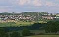
Freudenburg is a municipality in the Trier-Saarburg district in Rhineland-Palatinate . It belongs to the Saarburg-Kell association.
Geographical location
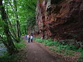
The place lies at the foot of the Eiderberg, a 439 meter high elevation. The state border with Saarland runs south of the main town, and the Kollesleuken district is about 1.5 kilometers to the west. Saarburg , the seat of the municipal administration , is about seven kilometers to the north-northeast, and to the southeast it is about eight kilometers to Mettlach in the Saarland . The area has a large number of hiking trails.
history
In 1337, King John of Bohemia , Count of Luxembourg, built the Freudenburg at the foot of the Eiderberg , known at that time as Freyding . As part of a castle protection system between Trier and Luxembourg , it served to secure the Trier-Metz military road. As early as 1346, Freudenburg was referred to as a “city” within the scope of an Electoral Trier collecting privilege. As a small agricultural town, Freudenburg took on central functions for the surrounding villages. The castle was rebuilt with the purchase of the Burggrafschaft Freyding by the Imperial Abbey of St. Maximin . In the dispute between the abbey and Elector Philipp Christoph von Sötern , the castle was occupied, destroyed and never rebuilt by electoral Trier troops in 1646. In the course of secularization , the United Hospitias were also assigned the ruins, which they sold to the community in 1861, which had security work carried out in 1908 and 1980, along with the former spiritual property .
On July 18, 1946, Freudenburg, together with 80 other communities in the districts of Trier and Saarburg , was annexed to the Saar area , which was separated from the rest of the French occupation zone in February 1946 and which at that time was no longer under the Allied Control Council. On June 6, 1947, this territorial separation was withdrawn to 21 municipalities, so Freudenburg came to the 1946 newly formed state of Rhineland-Palatinate .
On June 7, 1969, part of the community of Kirf with 101 residents was reunited with Freudenburg.
- Population development
The development of the population of Freudenburg in relation to today's municipality, the values from 1871 to 1987 are based on censuses:
|
|
Municipal council
The local council in Freudenburg consists of 16 council members, who were elected in the local elections on May 26, 2019 in a personalized proportional representation, and the honorary local mayor as chairman.
The distribution of seats in the local council:
| choice | SPD | CDU | UWF | WGR | total |
|---|---|---|---|---|---|
| 2019 | 6th | - | 6th | 4th | 16 seats |
| 2014 | 9 | - | 4th | 3 | 16 seats |
| 2009 | 9 | - | 4th | 3 | 16 seats |
| 2004 | 9 | 4th | 3 | - | 16 seats |
- UWF = Independent Voting Group Freudenburg e. V.
Attractions
- Freudenburg castle ruins from the 14th century
- A private mikveh of the former Jewish community exists in a private house .
- In the new building area above the town center (signposted) there is a Jewish cemetery, first documented for 1694 .
- In the district of Kollesleuken on the Leukbach is the Herrenmühle, a successor to the former Maximiner Mühle, which was destroyed in 1944. The mill is privately owned and has not been in operation since the late 1970s.
- Eiderberg nature reserve with numerous orchid species
- Rock formations in the Leuktal (Kollesleuk Switzerland) above the Herrenmühle
See also: List of cultural monuments in Freudenburg
Freudenburg, on the right edge of the picture castle ruins and church
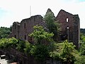
Freudenburg castle ruins

Catholic Parish Church of the Holy Trinity
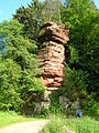
Pilsfelsen in "Kollesleuk Switzerland"
Rock formation in the Leuktal
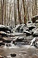
Winter in the Leukbachtal


Public institutions and sports facilities
Freudenburg has a primary school, a youth and community center as well as a kindergarten and children's playgrounds. There are two tennis courts, a gym and a sports field for leisure activities.
economy
Construction companies and small businesses as well as service companies shape the local working life. Freudenburg offers various guest and overnight stays.
literature
- Ernst Wackenroder : The art monuments of the Saarburg district . (= Paul Clemen (Hrsg.): Die Kunstdenkmäler der Rheinprovinz , Volume 15, III. Department). L. Schwann, Düsseldorf 1939 (reprint from the Academic Bookshop Interbook, Trier 1982), pp. 77–87.
Web links
- Internet presence of the municipality of Freudenburg
- Brief portrait of Freudenburg near Hierzuland , SWR television
- To search for cultural goods of the local community Freudenburg in the database of cultural goods in the Trier region .
- Freudenburg castle ruins around 1840 from the panorama of Trier and its surroundings (around 1840) via dilibri
- Link catalog on Freudenburg at curlie.org (formerly DMOZ )
Individual evidence
- ↑ State Statistical Office of Rhineland-Palatinate - population status 2019, districts, communities, association communities ( help on this ).
- ↑ Official municipality directory (= State Statistical Office of Rhineland-Palatinate [Hrsg.]: Statistical volumes . Volume 407 ). Bad Ems February 2016, p. 184 (PDF; 2.8 MB; footnote 26).
- ↑ State Statistical Office Rhineland-Palatinate: My village, my city. Retrieved July 15, 2019 .
- ^ The Regional Returning Officer Rhineland-Palatinate: Local elections 2019, city and municipal council elections

Aach | Ayl | Baldringen | Bekond | Notification | Beuren (high forest) | Bonerath | Damflos | Detzem | Ensch | Farschweiler | Fur | Fish | Pine | Franzenheim | Freudenburg | Geisfeld | Greimerath | Grimburg | Gusenburg | Gusterath | Gutweiler | Heddert | Stalling | Herl | Hermeskeil | Hinzenburg | Hinzert-Pölert | Hockweiler | Holzerath | Hedgehog | Irsch | Kanzem | Chasuble | Kastel-Staadt | Kell am See | Kenn | Kirf | Klüsserath | Conc | Cord | Korlingen | Köwerich | Lampades | Langsur | Leiwen | Lunge | Longuich | Lorscheid | Mandern | Mannebach | Mehring | Mertesdorf | Merzkirchen | Morscheid | Naurath (Eifel) | Naurath (forest) | Neuhütten | Newel | Nittel | Upper cheap | Ockfen | Ollmuth | Onsdorf | Osburg | Palzem | Paschel | Pellingen | Pluwig | Pölich | Ralingen | Swift oath | Reinsfeld | Riol | Riveris | Saarburg | Schillings | Schleich | Schoden | Schömerich | Schondorf | Schweich | Serrig | Sommerau | Taben-Rodt | Tawern | Temmels | Thomm | Thörnich | Trassem | Trierweiler | Trittenheim | Vierherrenborn | Waldrach | Waldweiler | Wasserliesch | Wawern | Waves | Welschbillig | Wiltingen | Wincheringen | Zemmer | Zerf | Züsch