
Shillings
| coat of arms | Germany map | |
|---|---|---|

|
Coordinates: 49 ° 38 ' N , 6 ° 47' E |
|
| Basic data | ||
| State : | Rhineland-Palatinate | |
| County : | Trier-Saarburg | |
| Association municipality : | Saarburg-Kell | |
| Height : | 480 m above sea level NHN | |
| Area : | 19.59 km 2 | |
| Residents: | 1182 (Dec. 31, 2019) | |
| Population density : | 60 inhabitants per km 2 | |
| Postal code : | 54429 | |
| Area code : | 06589 | |
| License plate : | TR, SAB | |
| Community key : | 07 2 35 119 | |
| Association administration address: | Schlossberg 6 54439 Saarburg |
|
| Website : | ||
| Local Mayor : | Markus Franzen ( CDU ) | |
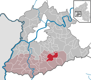
| Location of the local community Schillingen in the district of Trier-Saarburg | ||
  |
||


Schillingen is a municipality in the Trier-Saarburg district in Rhineland-Palatinate . It belongs to the Saarburg-Kell association.
geography
The place is in the Saar-Hunsrück Nature Park .
To shillings includes the residential places Büdelter Hof, Hof Burg Heid , castle Heider mill, Lindenhof, Schillinger mill Tannenhof, Four manor and light Berghof.
history
By the end of the 18th century, Schillingen, together with Waldweiler and half the village of Heddert, formed a separate imperial dominion under the sovereignty of the Trier cathedral chapter . In 1794 the Left Bank of the Rhine was taken by French revolutionary troops. From 1798 to 1814 Schillingen belonged to the canton Hermeskeil in the Saar department . Due to the agreements made at the Congress of Vienna (1815), the region came under the Kingdom of Prussia . The community was assigned to the mayor's office of Kell in the district of Trier , established in 1816, and belonged to the Rhine province from 1822 until the end of World War II . Schillingen has been part of the state of Rhineland-Palatinate since 1946 .
- Population development
The development of the population of Schillingen, the values from 1871 to 1987 are based on censuses:
|
|
religion
Schillingen is the seat of the Catholic parish of St. Albanus . The parish, together with the parishes of Mandern, Waldweiler and Lampaden and the Heddert branch chapel , has been part of the Schillingen parish community for several years , which also includes the parishes of Reinsfeld, Kell am See, Greimerath, Zerf and Hentern. Schillingen belongs to the Diocese of Trier .
politics
Municipal council
The local council in Schillingen consists of 16 council members, who were elected in a personalized proportional representation in the local elections on May 26, 2019 , and the honorary local mayor as chairman.
The distribution of seats in the municipal council:
| choice | SPD | CDU | total |
|---|---|---|---|
| 2019 | 9 | 7th | 16 seats |
| 2014 | 7th | 9 | 16 seats |
| 2009 | 9 | 7th | 16 seats |
| 2004 | 9 | 7th | 16 seats |
| 1999 | 10 | 6th | 16 seats |
coat of arms
|
|
Blazon : "In green a silver label, inside a red goose foot , flanked by two soaring, golden dragon tail horses (horse with dragon tail) ."
The coat of arms was approved on June 14, 1978. |
| Justification of the coat of arms: The coat of arms of the cathedral chapter indicates the centuries-long sovereignty of the Trier canons. The two mythical animals are reminiscent of a settlement of the place as early as Roman times. They are based on an image on a Roman grave monument found in the district of Schillingen. The color green symbolizes the abundance of forests. |
Culture and sights


Buildings
- The parish church of St. Albanus with its early Gothic tower is the most striking building in the town.
- On Schillinger and Hedderter area is located at the former railway station of Lampaden the castle Heid (farm Heid).
- In the summer of 2017 was the four-meter-high observation tower 7 Heads view a viewing platform created, a panoramic view over the hills of the Black Forest and the Osburger forest provides: Heidkopf (530 m), Rösterkopf (708 m), the Erbeskopf (816 m) , Sandkopf (757 m), Teufelskopf (695 m), Schimmelkopf (695 m) and Raukopf (Mandern) (524 m) form the panorama clockwise from the northwest.
See also: List of cultural monuments in Schillingen
Sports facilities
The sports and multi-purpose hall is located next to the primary school on the outskirts. The sports facilities, two soccer fields and three tennis courts are located outside of the village between Schillingen and Heddert.
Flonterbach reservoir
Between Schillingen and Heddert there is a small reservoir on the Flonterbach with the spit roast hall, a forest playground, a tree trunk labyrinth, a forest nature trail, a barefoot trail and the Fátima chapel .
societies
Sports clubs include the Schillingen-Heddert tennis club and the TuS Schillingen (football, gymnastics).
In addition to the sports clubs, there are several music clubs and choirs.
- Church choir "Cäcilia"
- Music Association "Cäcilia"
- Men's choir "Liederkranz" Schillingen
Economy and Infrastructure
In addition to small businesses, the place lives mainly from tourism and agriculture . Jobs can be found in the nearby Bilsteinwerk on the one hand, and in Trier on the other . Between Schillingen and Kell is the Hochwald outdoor swimming pool with a campsite and the basement reservoir .
The Schillingen station of the Ruwertalbahn was located near the Bilsteinwerk in Niederkell .
The Schillinger Panoramaweg is a dream loop on the Saar-Hunsrück-Steig .
Schillingen is the seat of the Schillingen-Kell am See primary school. The Realschule plus (secondary school with tenth grade) is located in Kell am See.
Web links
- Internet presence of the local community Schillingen
- Local community Schillingen on the website of the Saarburg-Kell association
- To search for cultural assets of the local community Schillingen in the database of cultural assets in the Trier region .
- Link catalog on Schillingen at curlie.org (formerly DMOZ )
Individual evidence
- ↑ State Statistical Office of Rhineland-Palatinate - population status 2019, districts, communities, association communities ( help on this ).
- ↑ State Statistical Office Rhineland-Palatinate (ed.): Official directory of the municipalities and parts of the municipality. Status: January 2019 [ Version 2020 is available. ] . S. 125 (PDF; 3 MB).
- ^ Wilhelm Fabricius : Explanations for the Historical Atlas of the Rhine Province, Die Karte von 1789 (2nd volume), Bonn 1898. P. 168, 491
- ↑ State Statistical Office Rhineland-Palatinate: My village, my city. Retrieved July 26, 2019 .
- ^ Parish community Schillingen. Retrieved July 26, 2019 .
- ^ The Regional Returning Officer Rhineland-Palatinate: Local elections 2019, city and municipal council elections

Aach | Ayl | Baldringen | Bekond | Notification | Beuren (high forest) | Bonerath | Damflos | Detzem | Ensch | Farschweiler | Fur | Fish | Pine | Franzenheim | Freudenburg | Geisfeld | Greimerath | Grimburg | Gusenburg | Gusterath | Gutweiler | Heddert | Stalling | Herl | Hermeskeil | Hinzenburg | Hinzert-Pölert | Hockweiler | Holzerath | Hedgehog | Irsch | Kanzem | Chasuble | Kastel-Staadt | Kell am See | Kenn | Kirf | Klüsserath | Conc | Cord | Korlingen | Köwerich | Lampades | Langsur | Leiwen | Lunge | Longuich | Lorscheid | Mandern | Mannebach | Mehring | Mertesdorf | Merzkirchen | Morscheid | Naurath (Eifel) | Naurath (forest) | Neuhütten | Newel | Nittel | Upper cheap | Ockfen | Ollmuth | Onsdorf | Osburg | Palzem | Paschel | Pellingen | Pluwig | Pölich | Ralingen | Swift oath | Reinsfeld | Riol | Riveris | Saarburg | Schillings | Schleich | Schoden | Schömerich | Schondorf | Schweich | Serrig | Sommerau | Taben-Rodt | Tawern | Temmels | Thomm | Thörnich | Trassem | Trierweiler | Trittenheim | Vierherrenborn | Waldrach | Waldweiler | Wasserliesch | Wawern | Waves | Welschbillig | Wiltingen | Wincheringen | Zemmer | Zerf | Züsch