
Sandkopf (Neuhütten)
| Sandhead | ||
|---|---|---|
.JPG) View from the farm road northwards to the Sandkopf with the concrete transmission tower |
||
| height | 757.4 m above sea level NHN | |
| location | District of Trier-Saarburg , Rhineland-Palatinate , Germany | |
| Mountains | Black Forest high forest , Hunsrück | |
| Coordinates | 49 ° 40 '39 " N , 7 ° 1' 40" E | |
|
||
| particularities | Transmission tower | |

The Sandkopf in the Black Forest high forest ( Hunsrück ) is 757.4 m above sea level. NHN the highest mountain in the Trier-Saarburg district , Rhineland-Palatinate . It is located between the places Züsch , Damflos , Malborn- Thiergarten, Börfink and Neuhütten near the Muhl district in the Neuhütten district.
The European long-distance hiking trail E3 , which stretches from the Black Sea to the Iberian Peninsula, runs along the paved agricultural road that passes by . The Pfaffenstraße (historical overland connection) led over the Sandkopf.
The Fuchsbau Jagdhaus auf dem Sandkopf is a single-storey half-timbered building from 1899 and a cultural monument .
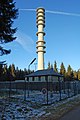
US directional radio station Muhl-Züsch
On the sand head, the former was radio position "Radio Relay Site Muhl-Züsch" the US Air Force with a 80 meter high concrete tower and other buildings, which was abandoned in the year of 2007.
In 2012 all buildings were dismantled except for the tower and the enclosure of a high concrete wall. The telecommunications tower is registered with the Federal Network Agency.
Radio Relay Site Muhl-Züsch after the abandonment in 2007.

former relay site after being abandoned in 2016.


Individual evidence
- ↑ a b Map service of the landscape information system of the Rhineland-Palatinate Nature Conservation Administration (LANIS map) ( notes )
- ↑ Entry on Jagdhaus Fuchsbau (Neuhütten municipality) in the database of cultural assets in the Trier region .
- ↑ Electromagnetic fields - EMF database radio system locations Location certificate no .: 59011379. Federal Network Agency for Electricity, Gas, Telecommunications, Post and Railways, accessed on August 17, 2020 .