
Börfink
| coat of arms | Germany map | |
|---|---|---|

|
Coordinates: 49 ° 41 ' N , 7 ° 5' E |
|
| Basic data | ||
| State : | Rhineland-Palatinate | |
| County : | Birch field | |
| Association municipality : | Birch field | |
| Height : | 515 m above sea level NHN | |
| Area : | 8.22 km 2 | |
| Residents: | 167 (Dec. 31, 2019) | |
| Population density : | 20 inhabitants per km 2 | |
| Postal code : | 54422 | |
| Area code : | 06782 | |
| License plate : | BIR | |
| Community key : | 07 1 34 011 | |
| LOCODE : | DE 68B | |
| Association administration address: | Schneewiesenstrasse 21 55765 Birkenfeld |
|
| Website : | ||
| Local Mayor : | Martin Döscher | |
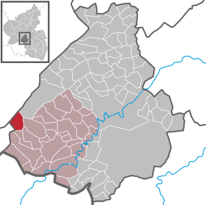
| Location of the local community Börfink in the district of Birkenfeld | ||
  |
||

Börfink is a municipality in the Birkenfeld district in Rhineland-Palatinate . It belongs to the Birkenfeld community .
geography
location
The place is on the Traunbach at the 816 meter high Erbeskopf in the Black Forest high forest in the Hunsrück . 78.8 percent of the district area is forested. To the southeast is Abentheuer and southwest lies the to Neuhütten belonging Muhl .
Börfink also includes the Einiederhof and Forellenhof Trauntal residential areas and the hamlet of Thranenweier.
Börfink is a national park community in the Hunsrück-Hochwald National Park .
climate
The annual precipitation is 1133 mm. The rainfall is very high. They are in the upper tenth of the values recorded in Germany. Lower values are registered at 91% of the measuring stations of the German Weather Service . The driest month is July, with the most rainfall in December. In December there is 1.5 times more rainfall than in July. Precipitation varies greatly. Higher seasonal fluctuations are registered at only 23% of the measuring stations .
history
Börfink belonged to the Hinteren Grafschaft Sponheim until the end of the 18th century and to the district of Trier in Prussian times .
The Börfink command bunker , called Bunker Erwin , was put into operation in 1964 in Erbeskopf. Among other things, it served as a secret NATO bunker for air surveillance in Central Europe during the Cold War .
After the assignment of the district Muhl with 150 inhabitants to the municipality of Neuhütten , which came into effect on November 7, 1970, the municipality, which was called Börfink-Muhl, was renamed Börfink on January 1, 1971 .
Population development
The development of the population of Börfink in relation to today's municipality, the values from 1871 to 1987 are based on censuses:
|
|
politics
Municipal council
The council in Börfink consists of six council members, who in the local elections on May 26, 2019 in a majority vote were elected, and the honorary mayor as chairman.
coat of arms
|
|
Blazon : "In the front, red-silver sheathed shield, which is divided obliquely to the left, behind a golden charcoal fire in black."
It was approved by the Koblenz District Government in 1972 . |
Economy and Infrastructure
The federal highway 41 runs in the east and the federal highway 62 in the south . In Neubrücke there is a train station on the Bingen – Saarbrücken line . The bus route 323 in the Rhein-Nahe-Nahverkehrsverbund connects Börfink with Birkenfeld.
tourism
One stage of the Saar-Hunsrück-Steig long-distance hiking trail ends in Börfink. One of the premium hiking trails in the Saar-Hunsrück region, known as dream loops , runs around Börfink . It is the approximately 9 kilometer long Börfinker Ochsentour , which among other things leads through a particularly protected moor area. The newly created national park island tour of 1.6 kilometers in length, which aims to convey "interesting facts about the origin, preservation and diversity of the species occurring there", runs in the Thranenweier district .
Photo gallery

Central in Börfink, the Dorfstrasse , which leads right through the small town

The bell tower with the Johann Peter pilgrim bell

Voluntary fire brigade and parish hall, built in 1842. The building served as a school until 1969

The listed old mill of Börfink

The national park monument Punkt am Traunbach , erected in 2015

A wooden footbridge leads on the National Park Dream Loop Börfinker Ochsentour through the specially protected moorland Ochsenbruch
-Dorfstrasse.jpg)
-Glockenturm.jpg)
-Freiwillige_Feuerwehr.jpg)
-Alte_M%C3%BChle.jpg)
-Nationalpark-Denkmal.jpg)
-Steg_im_Ochsenbruch.jpg)
See also
Web links
- Internet presence of the local community Börfink
- Literature about Börfink in the Rhineland-Palatinate State Bibliography
- In this country (SWR): Dorfstraße in Börfink from October 30, 2014, accessed on August 27, 2020
Individual evidence
- ↑ State Statistical Office of Rhineland-Palatinate - population status 2019, districts, communities, association communities ( help on this ).
- ↑ State Statistical Office Rhineland-Palatinate (ed.): Official directory of the municipalities and parts of the municipality. Status: January 2019 [ Version 2020 is available. ] . S. 28 (PDF; 3 MB).
- ↑ Official municipality directory (= State Statistical Office of Rhineland-Palatinate [Hrsg.]: Statistical volumes . Volume 407 ). Bad Ems February 2016, p. 190 (PDF; 2.8 MB).
- ↑ State Statistical Office Rhineland-Palatinate - regional data
- ^ The Regional Returning Officer Rhineland-Palatinate: Local elections 2019, city and municipal council elections
- ↑ Website of the Saar-Hunsrück-Steig, accessed on February 1, 2014
- ↑ German Hiking Institute: Börfinker Ochsentour accessed on August 27, 2020
- ↑ Birkenfelder Land: National Park Island Tour Thranenweier accessed on August 27, 2020

Adventure | Achtelsbach | Allenbach | Asbach | Baumholder | Mountains | Berglangenbach | Berschweiler at Baumholder | Berschweiler near Kirn | Birkenfeld | Bollenbach | Börfink | Breitenthal | Bruchweiler | Bridges | Buhlenberg | Bundenbach | Dambach | Dickesbach | Dienstweiler | Eckersweiler | Elkweiler | Ellenberg | Ellweiler | Fischbach | Fohren-Linden | Frauenberg | Gerach | Gimbweiler | Gollenberg | Gösenroth | Griebelschied | Hahnweiler | Hattgenstein | Hausen | Heimbach | Hellertshausen | Herborn | Herrstein | Hettenrodt | Hintertiefenbach | Hoppstädten-Weiersbach | Horbruch | Hottenbach | Idar-Oberstein | Kempfeld | Kirschweiler | Kronweiler | Krummenau | Boring | Leisel | Leitzweiler | Mackenrodt | Meckenbach | Mettweiler | Mittelreidenbach | Mörschied | Niederbrombach | Niederhambach | Niederhosenbach | Niederwörresbach | Nohen | Oberbrombach | Oberhambach | Oberhosenbach | Upper brain | Oberreidenbach | Oberwörresbach | Reichenbach | Rhaunen | Rimsberg | Rinzenberg | Rohrbach | Rötsweiler-Nockenthal | Rückweiler | Ruschberg | Showers | Schmidthachenbach | Schmissberg | Schwerbach | Swelling | Sensweiler | Sien | Sienhachenbach | Siesbach | Sonnenberg-Winnenberg | Sonnschied | Stipshausen | Sulzbach | Veitsrodt | Vollmersbach | Pastures | Weitersbach | Wickenrodt | Wilzenberg-Hussweiler | Wirschweiler