
Niederbrombach
| coat of arms | Germany map | |
|---|---|---|

|
Coordinates: 49 ° 41 ′ N , 7 ° 15 ′ E |
|
| Basic data | ||
| State : | Rhineland-Palatinate | |
| County : | Birch field | |
| Association municipality : | Birch field | |
| Height : | 319 m above sea level NHN | |
| Area : | 7.28 km 2 | |
| Residents: | 482 (Dec. 31, 2019) | |
| Population density : | 66 inhabitants per km 2 | |
| Postal code : | 55767 | |
| Area code : | 06787 | |
| License plate : | BIR | |
| Community key : | 07 1 34 057 | |
| Association administration address: | Schneewiesenstrasse 21 55765 Birkenfeld |
|
| Website : | ||
| Local Mayor : | Bernd Brombacher | |
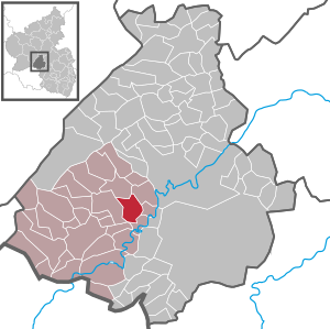
| Location of the local community Niederbrombach in the Birkenfeld district | ||
  |
||


Niederbrombach is a municipality in the Birkenfeld district in Rhineland-Palatinate . It belongs to the Birkenfeld community .
geography
The municipality Niederbrombach is located on a Talbogen that of Birkenfeld by Idar-Oberstein leading Federal Straße 41 .
Four valleys meet from north to south, east and west. In the basin, Hambach, Schwollbach and Rothenbach unite to form a body of water that flows into the Nahe under the name Schwollbach near Kronweiler . Niederbrombach is surrounded in the north by the Hömelskopf and the Heidkopf, in the east by the Pferdshöhe and the Brombacher Höhe, in the south by the Rothenbachberg, the Winnenberg and Hochkastell and finally in the west by the Kleb and the Bauterskopf.
Niederbrombach also includes the Fischerhof , Manzenbach, Lärchenhof and Robinienhof residential areas .
history
In the oldest documents one finds the name form Brambach or Branbach . Only in modern times is Niederbrombach differentiated from Oberbrombach.
Brombach was the suburb of the Trierian , then the Sponheimischen possessions south of the Idarwald , and within the high court and district Brombach had become and remained the suburb of its own large ban , its own care and its own parish. Secular and ecclesiastical property coincided so completely that in the 18th century the term parish was also applied to the administrative district. During the course of the Middle Ages, the great spell was subject to increasing disintegration as the settlement progressed. First of all, a dichotomy took place in the early Middle Ages, which was to be repeated later in the 18th century in the church.
Niederbrombach was the center of the old ban, so the care, the court and the parish . It was not until the middle of the 18th century that Brombach care was shared not only for the church but also for the administration and the court. Under French rule from 1797 to 1814, the parish was replaced by a mairie . From 1815 to 1817 the Brombacher care was Prussian, from 1817 to 1937 Oldenburg , then again for a few years Prussian . Since 1946 this area belongs to the federal state Rhineland-Palatinate .
Population development
The development of the population of Niederbrombach, the values from 1871 to 1987 are based on censuses:
|
|
politics
Municipal council
The council in Niederbrombach consists of eight council members, who in the local elections on May 26, 2019 in a majority vote were elected, and the honorary mayor as chairman.
coat of arms
|
|
Blazon : "Two black arcadesundertwo rows of gold and two rows ofred and silver shield head ."
The coat of arms was approved by decree of the Ministry of the Interior dated August 20, 1965. |
| Reasons for the coat of arms: The red and silver shield head symbolizes the former affiliation of the place to the rear county of Sponheim (red and silver uncounted), Oberamt Birkenfeld. As part of the building, the arcades symbolize the old parish church of Niederbrombach (at that time Brambach or Branbach). |
Economy and Infrastructure
Shops, bank branches, handicraft businesses, innkeepers, elementary and secondary school plus with a sports hall, kindergarten, as well as an outdoor sports facility near the school are available, so that extensive self-sufficiency is ensured.
The federal road 41 , which leads to the federal motorway 62 in the south , runs through the village . In Kronweiler there is a train station on the Bingen – Saarbrücken line .
Personalities
Paul Brenner , born September 11, 1905 in Niederbrombach; † November 17, 1988 in Birkenfeld, German lawyer and politician (CDU)
Johannes Lichtenberger , * around 1426 in Grünbach near Baumholder; † before April 1503 in Niederbrombach, German astrologer. (Catholic) pastor in Brambach , as Niederbrombach was then called.
See also
Web links
- Local community Niederbrombach on the website of the Verbandsgemeinde Birkenfeld
- Local portrait of SWR television from December 4, 2008 (video, 8 minutes)
- Literature about Niederbrombach in the Rhineland-Palatinate state bibliography
Individual evidence
- ↑ a b State Statistical Office of Rhineland-Palatinate - population status 2019, districts, municipalities, association communities ( help on this ).
- ↑ State Statistical Office Rhineland-Palatinate (ed.): Official directory of the municipalities and parts of the municipality. Status: January 2019 [ Version 2020 is available. ] . S. 29 (PDF; 3 MB).
- ↑ a b c Heinrich Baldes: Niederbrombach In: Geschichtliche Heimatkunde der Birkenfelder Landschaft from primeval times to 1817 Reprint of the original edition from 1923, pp. 345–357.
- ↑ State Statistical Office Rhineland-Palatinate - regional data
- ^ The Regional Returning Officer Rhineland-Palatinate: Local elections 2019, city and municipal council elections

Adventure | Achtelsbach | Allenbach | Asbach | Baumholder | Mountains | Berglangenbach | Berschweiler at Baumholder | Berschweiler near Kirn | Birkenfeld | Bollenbach | Börfink | Breitenthal | Bruchweiler | Bridges | Buhlenberg | Bundenbach | Dambach | Dickesbach | Dienstweiler | Eckersweiler | Elkweiler | Ellenberg | Ellweiler | Fischbach | Fohren-Linden | Frauenberg | Gerach | Gimbweiler | Gollenberg | Gösenroth | Griebelschied | Hahnweiler | Hattgenstein | Hausen | Heimbach | Hellertshausen | Herborn | Herrstein | Hettenrodt | Hintertiefenbach | Hoppstädten-Weiersbach | Horbruch | Hottenbach | Idar-Oberstein | Kempfeld | Kirschweiler | Kronweiler | Krummenau | Boring | Leisel | Leitzweiler | Mackenrodt | Meckenbach | Mettweiler | Mittelreidenbach | Mörschied | Niederbrombach | Niederhambach | Niederhosenbach | Niederwörresbach | Nohen | Oberbrombach | Oberhambach | Oberhosenbach | Upper brain | Oberreidenbach | Oberwörresbach | Reichenbach | Rhaunen | Rimsberg | Rinzenberg | Rohrbach | Rötsweiler-Nockenthal | Rückweiler | Ruschberg | Showers | Schmidthachenbach | Schmissberg | Schwerbach | Swelling | Sensweiler | Sien | Sienhachenbach | Siesbach | Sonnenberg-Winnenberg | Sonnschied | Stipshausen | Sulzbach | Veitsrodt | Vollmersbach | Pastures | Weitersbach | Wickenrodt | Wilzenberg-Hussweiler | Wirschweiler