
Sonnenberg-Winnenberg
| coat of arms | Germany map | |
|---|---|---|

|
Coordinates: 49 ° 40 ′ N , 7 ° 17 ′ E |
|
| Basic data | ||
| State : | Rhineland-Palatinate | |
| County : | Birch field | |
| Association municipality : | Birch field | |
| Height : | 400 m above sea level NHN | |
| Area : | 2.87 km 2 | |
| Residents: | 437 (Dec 31, 2019) | |
| Population density : | 152 inhabitants per km 2 | |
| Postal code : | 55767 | |
| Area code : | 06787 | |
| License plate : | BIR | |
| Community key : | 07 1 34 085 | |
| Community structure: | 2 districts | |
| Association administration address: | Schneewiesenstrasse 21 55765 Birkenfeld |
|
| Website : | ||
| Local Mayor : | Ottmar Ding | |
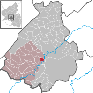
| Location of the local community Sonnenberg-Winnenberg in the Birkenfeld district | ||
  |
||

Sonnenberg-Winnenberg is a municipality in the Birkenfeld district in Rhineland-Palatinate . It belongs to the Birkenfeld community .
geography
The "double community", consisting of the two districts Sonnenberg and Winnenberg, is located on the Nahe . In the east on the opposite bank of the Nahe is Frauenberg , in the south Kronweiler , in the west Niederbrombach and in the north is Idar-Oberstein .
The residential areas Birkensiedlung, Hohensteiner Hof and Schlesierhof also belong to Sonnenberg-Winnenberg .
Population development
The development of the population of Sonnenberg-Winnenberg, the values from 1871 to 1987 are based on censuses:
|
|
politics
Municipal council
The council in Sonnenberg-Winnenberg consists of eight council members, who in the local elections on May 26, 2019 in a majority vote were elected, and the honorary mayor as chairman. In 2009–2014 the municipality council had twelve council members.
coat of arms
|
|
Blazon : "Under a red-silver shield head in blue a rising black tip, covered with a golden 'W', in the field a golden sun limited by the tip." |
| Justification for the coat of arms: The checkerboard pattern is reminiscent of the former affiliation to the Hinteren Grafschaft Sponheim . The name of the place is shown below. The coat of arms was approved by the Rhineland-Palatinate Ministry of the Interior in 1963 . |
Economy and Infrastructure
In the northwest runs the federal highway 41 , which leads to the federal highway 62 in the south . The station in Sonnenberg was shut down in 1963. The nearest stop on the Bingen – Saarbrücken railway line is in Kronweiler .
See also
- List of cultural monuments in Sonnenberg-Winnenberg
- List of natural monuments in Sonnenberg-Winnenberg
Web links
- Local community Sonnenberg-Winnenberg on the website of the Verbandsgemeinde Birkenfeld
- Literature about Sonnenberg-Winnenberg in the Rhineland-Palatinate state bibliography
Individual evidence
- ↑ a b State Statistical Office of Rhineland-Palatinate - population status 2019, districts, municipalities, association communities ( help on this ).
- ↑ State Statistical Office Rhineland-Palatinate (ed.): Official directory of the municipalities and parts of the municipality. Status: January 1, 2017 [ Version 2020 is available. ] . S. 19 (PDF; 1.9 MB).
- ↑ State Statistical Office Rhineland-Palatinate - regional data
- ^ The Regional Returning Officer Rhineland-Palatinate: Local elections 2019, city and municipal council elections

Adventure | Achtelsbach | Allenbach | Asbach | Baumholder | Mountains | Berglangenbach | Berschweiler at Baumholder | Berschweiler near Kirn | Birkenfeld | Bollenbach | Börfink | Breitenthal | Bruchweiler | Bridges | Buhlenberg | Bundenbach | Dambach | Dickesbach | Dienstweiler | Eckersweiler | Elkweiler | Ellenberg | Ellweiler | Fischbach | Fohren-Linden | Frauenberg | Gerach | Gimbweiler | Gollenberg | Gösenroth | Griebelschied | Hahnweiler | Hattgenstein | Hausen | Heimbach | Hellertshausen | Herborn | Herrstein | Hettenrodt | Hintertiefenbach | Hoppstädten-Weiersbach | Horbruch | Hottenbach | Idar-Oberstein | Kempfeld | Kirschweiler | Kronweiler | Krummenau | Boring | Leisel | Leitzweiler | Mackenrodt | Meckenbach | Mettweiler | Mittelreidenbach | Mörschied | Niederbrombach | Niederhambach | Niederhosenbach | Niederwörresbach | Nohen | Oberbrombach | Oberhambach | Oberhosenbach | Upper brain | Oberreidenbach | Oberwörresbach | Reichenbach | Rhaunen | Rimsberg | Rinzenberg | Rohrbach | Rötsweiler-Nockenthal | Rückweiler | Ruschberg | Showers | Schmidthachenbach | Schmissberg | Schwerbach | Swelling | Sensweiler | Sien | Sienhachenbach | Siesbach | Sonnenberg-Winnenberg | Sonnschied | Stipshausen | Sulzbach | Veitsrodt | Vollmersbach | Pastures | Weitersbach | Wickenrodt | Wilzenberg-Hussweiler | Wirschweiler