Nohen
| coat of arms | Germany map | |
|---|---|---|

|
Coordinates: 49 ° 38 ' N , 7 ° 15' E |
|
| Basic data | ||
| State : | Rhineland-Palatinate | |
| County : | Birch field | |
| Association municipality : | Birch field | |
| Height : | 320 m above sea level NHN | |
| Area : | 7.5 km 2 | |
| Residents: | 329 (Dec. 31, 2019) | |
| Population density : | 44 inhabitants per km 2 | |
| Postal code : | 55767 | |
| Area code : | 06789 | |
| License plate : | BIR | |
| Community key : | 07 1 34 061 | |
| Association administration address: |
Schneewiesenstrasse 21 55765 Birkenfeld |
|
| Website : | ||
| Local Mayor : | Sascha Loch | |
| Location of the local community of Nohen in the Birkenfeld district | ||
Nohen is a municipality in the Birkenfeld district in Rhineland-Palatinate . It belongs to the Birkenfeld community .
geography
The place is at the confluence of the Röhmbach in the Nahe . To the west is Rimsberg , in the north Kronweiler , east Reichenbach and south is Heimbach .
history
The settlement of the place can be traced back to the formerly convenient location on one of the few fords in the narrow upper valley of the Nahe.
As an indication of its geographical importance, the fact that the place is the only one along the entire river to be named after the river name can be assessed. Here one of the oldest north-south traffic and trade routes in the region crossed the Nahe. This "bronze road" from Glan via Nohen to Moselle was developed in Roman times as a cross-connection between the roads from Mainz to Trier and from Mainz to Metz .
The military-strategic importance of the road connection with the ford and the bridge was also high. On the night of September 23rd to 24th and on the morning of September 24th, 1635, after the defeat at the Battle of Nördlingen, a Swedish-French army under the leadership of Duke Bernhard of Saxe-Weimar won that of the far superior victorious Imperial army under Count Gallas was pursued, the transition across the river and the subsequent retreat via Birkenfeld to Wallerfangen .
Nohen belonged to the late 18th century to the Rear County of Sponheim and the was Oberamt Birkenfeld belonging Care Rimsberg assigned. In 1607 16 families were counted in Nohen, in 1699 there were only eight, the number of which rose to 51 by 1772. In 1790 the place had 202 inhabitants, the district of Nohen covered about 761 hectares .
In 1794 the Left Bank of the Rhine was taken by French revolutionary troops. From 1798 to 1814 Nohen belonged to the canton Baumholder in the Saardepartement . As a result of the agreements made at the Congress of Vienna (1815), the region became part of the Oldenburg Principality of Birkenfeld in 1817 . The municipality of Nohen was assigned to the Birkenfeld mayor in the Birkenfeld office. From 1918 on, Nohen belonged to the Oldenburg "Landesteil Birkenfeld" and in 1937 came to the Prussian district of Birkenfeld . Nohen has been part of the state of Rhineland-Palatinate since 1946 .
Population development
The development of the population of Nohen, the values from 1871 to 1987 are based on censuses:
|
|
religion
Since the Reformation was introduced in 1557, Nohen has been predominantly evangelical . The Protestant community Nohen (which includes the local church Rimsberg part) of the Evangelical Church of Birkenfeld is since 1823 with the second parish parish officially connected .
politics
Municipal council
The municipal council in Nohen consists of eight council members, who were elected by a majority vote in the local elections on May 26, 2019 , and the honorary local mayor as chairman.
coat of arms
|
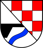
Blazon : "In a diagonally divided shield in front in silver, a black bridge cut in the division over an oblique left blue wavy band, behind red-silver sheathed."
It was approved by the Rhineland-Palatinate Ministry of the Interior in 1963 . |
|
Economy and Infrastructure
The federal highway 41 runs in the west and the federal highway 62 in the south . There is a train station on the Bingen – Saarbrücken railway line in town .
See also
Web links
- Local community Nohen on the website of the Verbandsgemeinde Birkenfeld
- Local portrait with film contributions in the broadcast For this country of SWR television on 10 February 2010 (video, 8 minutes)
- Literature about Nohen in the Rhineland-Palatinate State Bibliography
Individual evidence
- ↑ a b State Statistical Office of Rhineland-Palatinate - population status 2019, districts, municipalities, association communities ( help on this ).
- ^ Wilhelm Fabricius : Explanations of the Historical Atlas of the Rhine Province, Die Karte von 1789 (2nd volume), Bonn 1898. P. 443, 456
- ↑ State Statistical Office Rhineland-Palatinate: My village, my city. Retrieved May 18, 2020 .
- ^ The Regional Returning Officer Rhineland-Palatinate: Local elections 2019, city and municipal council elections.


