
Rückweiler
| coat of arms | Germany map | |
|---|---|---|

|
Coordinates: 49 ° 35 ' N , 7 ° 14' E |
|
| Basic data | ||
| State : | Rhineland-Palatinate | |
| County : | Birch field | |
| Association municipality : | Baumholder | |
| Height : | 500 m above sea level NHN | |
| Area : | 2.75 km 2 | |
| Residents: | 388 (Dec. 31, 2019) | |
| Population density : | 141 inhabitants per km 2 | |
| Postal code : | 55776 | |
| Area code : | 06789 | |
| License plate : | BIR | |
| Community key : | 07 1 34 074 | |
| Association administration address: | Am Weiherdamm 1 55774 Baumholder |
|
| Website : | ||
| Local Mayor : | Lutz Altekrüger | |
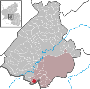
| Location of the local community of Rückweiler in the Birkenfeld district | ||
  |
||

Rückweiler is a municipality in the Birkenfeld district in Rhineland-Palatinate . It belongs to the Baumholder community .
history
The place was first mentioned in a document on March 5, 1332 as Rickwilre . After changing rulers and various disputes, Rückweiler was assigned to the county of Veldenz in an arbitration award in 1440 . With this it fell four years later to Pfalz-Zweibrücken .
In 1794 the Left Bank of the Rhine was taken by French revolutionary troops. From 1798 to 1814, Rückweiler belonged to the canton Baumholder in the Saar department . Due to the agreements reached at the Congress of Vienna (1815), the region came to the Saxon-Coburg principality of Lichtenberg in 1816 , to which it belonged until 1834. The community of Rückweiler initially belonged to the mayor's office of Berschweiler , from 1823 to the mayor's office of Burglichtenberg (see also the list of municipalities in the Principality of Lichtenberg ). After the sale to Prussia and the dissolution of the Principality of Lichtenberg, Rückweiler came to the newly established St. Wendel district in the Rhine province . Rückweiler has been part of the Birkenfeld district since 1937 and part of the state of Rhineland-Palatinate since 1946 .
- Population development
The development of the population of Rückweiler, the values from 1871 to 1987 are based on censuses:
|
|
politics
Municipal council
The council in Rückweiler consists of eight council members, who in the local elections on May 26, 2019 in a majority vote were elected, and the honorary mayor as chairman.
coat of arms
|
|
Blazon : "In a divided shield above in silver a red-armored and tongued growing blue lion, below in green a golden harvest wreath wrapped with a red ribbon, covered with a golden cross." |
|
Reasons for the coat of arms: The blue lion refers to the former belonging to the County of Veldenz . The harvest cross commemorates the annual harvest festival.
The coat of arms was approved by the Rhineland-Palatinate Ministry of the Interior in 1965. |
Culture and sights
The Herz-Jesu-Kirche, also known as Heidedom, was built in 1908 in the Gothic style.
See also: List of cultural monuments in Rückweiler
Economy and Infrastructure
Rückweiler has a kindergarten and a village community center. The federal motorway 62 runs to the south . In Heimbach there is a train station on the Bingen – Saarbrücken line .
Web links
- Local community Rückweiler on the website of the association community Baumholder
- Literature about Rückweiler in the Rhineland-Palatinate state bibliography
Individual evidence
- ↑ a b State Statistical Office of Rhineland-Palatinate - population status 2019, districts, municipalities, association communities ( help on this ).
- ↑ State Statistical Office Rhineland-Palatinate - regional data
- ^ The Regional Returning Officer Rhineland-Palatinate: Local elections 2019, city and municipal council elections

Adventure | Achtelsbach | Allenbach | Asbach | Baumholder | Mountains | Berglangenbach | Berschweiler at Baumholder | Berschweiler near Kirn | Birkenfeld | Bollenbach | Börfink | Breitenthal | Bruchweiler | Bridges | Buhlenberg | Bundenbach | Dambach | Dickesbach | Dienstweiler | Eckersweiler | Elkweiler | Ellenberg | Ellweiler | Fischbach | Fohren-Linden | Frauenberg | Gerach | Gimbweiler | Gollenberg | Gösenroth | Griebelschied | Hahnweiler | Hattgenstein | Hausen | Heimbach | Hellertshausen | Herborn | Herrstein | Hettenrodt | Hintertiefenbach | Hoppstädten-Weiersbach | Horbruch | Hottenbach | Idar-Oberstein | Kempfeld | Kirschweiler | Kronweiler | Krummenau | Boring | Leisel | Leitzweiler | Mackenrodt | Meckenbach | Mettweiler | Mittelreidenbach | Mörschied | Niederbrombach | Niederhambach | Niederhosenbach | Niederwörresbach | Nohen | Oberbrombach | Oberhambach | Oberhosenbach | Upper brain | Oberreidenbach | Oberwörresbach | Reichenbach | Rhaunen | Rimsberg | Rinzenberg | Rohrbach | Rötsweiler-Nockenthal | Rückweiler | Ruschberg | Showers | Schmidthachenbach | Schmissberg | Schwerbach | Swelling | Sensweiler | Sien | Sienhachenbach | Siesbach | Sonnenberg-Winnenberg | Sonnschied | Stipshausen | Sulzbach | Veitsrodt | Vollmersbach | Pastures | Weitersbach | Wickenrodt | Wilzenberg-Hussweiler | Wirschweiler