
District of St. Wendel
| coat of arms | Germany map |
|---|---|

|

Coordinates: 49 ° 31 ' N , 7 ° 6' E |
| Basic data | |
| State : | Saarland |
| Administrative headquarters : | St. Wendel |
| Area : | 476.22 km 2 |
| Residents: | 87,007 (Dec. 31, 2019) |
| Population density : | 183 inhabitants per km 2 |
| License plate : | WND |
| Circle key : | 10 0 46 |
| NUTS : | DEC06 |
| Circle structure: | 8 municipalities |
| Address of the district administration: |
Mommstrasse 21-31 66606 St. Wendel |
| Website : | |
| District Administrator : | Udo Recktenwald ( CDU ) |
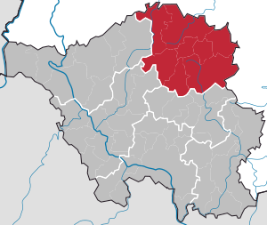
| Location of the district of St. Wendel in Saarland | |
  |
|
The district of St. Wendel is a district in Saarland .
geography
location
The largest part of the district belongs to the nearby England , the north still has a share in the foothills of the Hunsrück .
Neighboring areas
The district borders in a clockwise direction in the northwest on the districts of Trier-Saarburg , Birkenfeld and Kusel (all in Rhineland-Palatinate ) and on the districts of Neunkirchen , Saarlouis and Merzig-Wadern (all in Saarland).
history
Until the end of the 18th century, the area of the district of Sankt Wendel belonged to different dominions ( Kurtrier , Nassau-Saarbrücken , Pfalz-Zweibrücken , Lorraine ). From 1798 to 1814 the region was part of the French department de la Sarre . As a result of the Congress of Vienna (1815), Duke Ernst I of Saxe-Coburg-Saalfeld established the Principality of Lichtenberg in 1816 , which he sold to Prussia in 1834 . This then formed the Sankt Wendel district within the Trier government district in the Rhine Province .
A change in the territorial situation occurred in 1920 when, as a result of the entry into force of the Versailles Treaty (1919), the Saar area was placed under a special administration of the League of Nations . The south-western part of the then St. Wendel district (St. Wendel, Oberthal, Tholey, Marpingen, Namborn, Ostertal without black earth) came to the Saar area.
The town of Baumholder, now outside the Saar area, and 67 rural communities in the area between Glan and Nahe formed the remaining district of Sankt Wendel-Baumholder with its administrative headquarters in Baumholder, which remained in the Trier administrative district of the Rhine province. As a result, the Sankt Wendel district lost around two thirds of its territory. After the League of Nations administration ended on March 1, 1935, the old territorial conditions were not restored. The "Saarland", that was the official name of the area, came under direct Reich administration. The remainder of the district remained in the Rhine Province and was incorporated into the Birkenfeld district in the Koblenz district on April 1, 1937 .
After the seizure of power of the Nazis in 1933 in the German Reich citizens of (today's) county area survived, although only a few kilometers apart, in two completely different political realities: During the German Empire was associated the northeast in the power field of Nazis who the remained Saar associated Southwest under international League of Nations administration. The latter, like the entire Saar area, therefore played a key role as a refuge for Germans persecuted by National Socialism and as a hub for smuggling anti-racist propaganda into the German Reich. This is particularly clear when looking at the municipality of Namborn , which was directly on the border on the Saar region. Here the premium hiking trail “Smuggler Path” tells this part of the history of the district. After the clear vote in the Saar vote on January 13, 1935 in favor of an annexation to the German Reich , this was carried out on March 1 of the same year. As a result, as in the whole of Germany, there was massive persecution of opposition members and citizens of the Jewish faith in the south-western area of today's St. Wendel district, but also resistance to National Socialist crimes.
From April 1, 1943 to August 1, 1945, the St. Wendel district temporarily lost its independence, as the then Gauleitung Westmark ordered the merger with the Ottweiler district .
The Saar state , formed in 1946, was spatially larger than the area of the League of Nations administration (1920–1935); the district of St. Wendel was also enlarged. First, on July 18, 1946, the French military government took over the municipalities of Bosen , Eckelhausen , Eisen , Eiweiler , Gehweiler , Gonnesweiler , Grügelborn , Hirstein , Leitersweiler , Mosberg-Richweiler , Neunkirchen , Reitscheid , Schwarzenbach , Selbach , Sötern , Steinberg -ckenhardt , Türkismühle and Walhausen reclassified from the Birkenfeld district to the St. Wendel district.
On 1 October 1946, the communities were Bierfeld , Braunshausen , Buweiler-Rathen , Kastel , costs Bach , Nonnweiler , Otzenhausen , Primstal and Sitzerath from the dissolved district Wadern and the municipalities Weiler , hasborn-dautweiler , Lindscheid , Neipel , chafing , Sotzweiler , Theley , Tholey and Überroth-Niederhofen reclassified from the district of Ottweiler to the district of St. Wendel. In return, the communities of Steinbach and Wetschhausen moved from the St. Wendel district to the Ottweiler district.
On June 7, 1947, the communities of Bubach , Hoof , Niederkirchen , Marth , Osterbrücken and Saal from the Palatinate district of Kusel and the communities of Asweiler-Eitzweiler , Freisen , Haupersweiler , Nohfelden , Oberkirchen , Schwarzerden and Wolfersweiler from the Birkenfeld district in the district of St. Wendel reclassified.
As part of the regional and administrative reform in Saarland , which came into force on January 1, 1974, the municipalities of Buweiler-Rathen and Kostenbach left the district and became part of the town of Wadern in the Merzig-Wadern district. The municipality of Mainzweiler also left the district and became part of the city of Ottweiler in the Neunkirchen district. In return, the community of Berschweiler , until then part of the district of Ottweiler, became part of Marpingen in the district of St. Wendel.
Most recently, the district was changed in 2003 through a state treaty between Saarland and Rhineland-Palatinate . A street belonging to the Saarland Haupersweiler (municipality of Freisen ), which was about one kilometer from the village and geographically directly bordered the area of the local municipality of Herchweiler (district of Kusel), was assigned to the state of Rhineland-Palatinate.
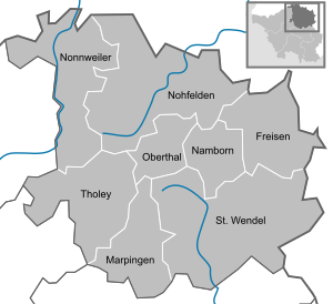
Since the completion of the municipal reform in 1974, the district of Sankt Wendel has comprised eight communities, including the district town of Sankt Wendel, which is also the only town in the district. The smallest municipality is Oberthal .
Population development
| year | Residents | source |
|---|---|---|
| 1847 | 37.503 | |
| 1871 | 42,876 | |
| 1885 | 47.202 | |
| 1900 | 49.186 | |
| 1910 | 55.025 | |
| 1939 | 55.025 | |
| 1960 | 85,600 | |
| 1970 | 93,200 | |
| 1980 | 93,200 | |
| 1990 | 93,500 | |
| 2000 | 95,400 | |
| 2010 | 90,596 | |
| 2018 | 87,397 |
religion
The Catholic parishes in the district belong to the dioceses of Trier and Speyer . Attempts in the years of the autonomous Saar state (1947–1956) to also form an independent Saar bishopric (as the seat of which St. Wendel would definitely have been considered) failed.
The Protestant population of the district had belonged to the Rhine Province since 1826 with the consistory in Koblenz in the Evangelical Church in Prussia (EKiP). After the state of Prussia was dissolved, this church province became independent on November 12, 1948 and has since formed the Evangelical Church in the Rhineland ; Most of the Protestant parishes in the district belong to the Rhenish Church. The parishes of Hoof and Niederkirchen belong to the Deanery Kusel in the Evangelical Church of the Palatinate .
politics
District council
The district council is the municipal representative body in the St. Wendel district. The citizens decide on its composition every five years.
The district election on May 26, 2019 led to the result shown on the right and the resulting distribution of seats:
- Overview of the results of past district council elections
| Parties and constituencies | % 2019 |
Seats 2019 |
% 2014 |
Seats 2014 |
% 2009 |
Seats 2009 |
% 2004 |
Seats 2004 |
% 1999 |
% 1994 |
% 1989 |
% 1984 |
|
|---|---|---|---|---|---|---|---|---|---|---|---|---|---|
| CDU | Christian Democratic Union of Germany | 48.3 | 14th | 51.4 | 15th | 51.6 | 14th | 61.0 | 18th | 55.7 | 48.5 | 46.2 | 48.9 |
| SPD | Social Democratic Party of Germany | 26.6 | 8th | 33.4 | 9 | 31.6 | 9 | 32.2 | 9 | 40.1 | 42.0 | 44.2 | 43.6 |
| GREEN | Alliance 90 / The Greens | 7.8 | 2 | 3.3 | 1 | 4.1 | 1 | 3.9 | 0 | 2.7 | 4.6 | 4.7 | 4.4 |
| AfD | Alternative for Germany | 6.0 | 1 | 4.3 | 1 | - | - | - | - | - | - | - | - |
| THE LEFT | THE LEFT | 4.6 | 1 | 4.5 | 1 | 8.9 | 2 | - | - | - | - | - | - |
| FREE VOTERS | FREE VOTERS | 4.3 | 1 | - | - | - | - | - | - | - | - | - | - |
| FDP | Free Democratic Party | 2.4 | 0 | 1.3 | 0 | 3.9 | 1 | 2.9 | 0 | 1.4 | 1.3 | 2.6 | 2.8 |
| PIRATES | Pirate Party Germany | - | - | 1.9 | 0 | - | - | - | - | - | - | - | - |
| REP | The Republicans | - | - | - | - | - | - | - | - | - | 2.3 | - | - |
| NPD | National Democratic Party of Germany | - | - | - | - | - | - | - | - | - | - | 2.3 | - |
| total | 100.0 | 27 | 100.0 | 27 | 100.0 | 27 | 100.0 | 27 | 100.0 | 100.0 | 100.0 | 100.0 | |
| voter turnout | 73.6% | 65.1% | 69.5% | 67.3% | 73.7% | 82.6% | 87.3% | 84.7% | |||||
District administrators
These goods:
- 1835–1848 Theodor Erasmus Engelmann
- 1848 Eduard Otto Spangenberg (acting)
- 1848–1885 Karl Hermann Rumschöttel
- 1885–1900 Alwin von Hagen
- 1900–1906 Wilhelm Momm
- 1906–1917 Otto von Aschoff
- 1917–1919 Hermann Sommer
- 1919–1929 Karl Alfred Friedrich
- 1929–1935 Franz Schmitt
- 1935–1942 Leonhard Lorscheider
- 1942–1945 Rech
- 1945–1946 Franz Heinrich Strauss
- 1946–1961 Paul Schütz
- 1961–1973 Werner Zeyer , CDU , later Prime Minister of Saarland
- 1973–1974 Gerhard Breit, CDU, later permanent representative of the Minister of the Interior until 1985
- 1974–1992 Waldemar Marner, CDU
- 1992–2007 Franz Josef Schumann , CDU
- 2008– Udo Recktenwald , CDU
The direct election of the district administrator in 2007 had the following result:
| candidate | Political party | Election result |
|---|---|---|
| Udo Recktenwald | CDU | 52.4% |
| Magnus Jung | SPD | 38.6% |
| Kristin Günther | Alliance 90 / The Greens | 9.0% |
coat of arms
The shield is divided into silver and blue. Inside there is a red-tongued and red-armored lion with changed colors, covered with a golden heart shield. In this there is in turn a red heraldic lily.
City and municipalities
(Population figures on December 31, 2019)

|
- Former parishes
Many former municipalities in the district lost their independence on January 1, 1974:
- Asweiler , Eitzweiler , Grügelborn , Haupersweiler , Oberkirchen , Reitscheid and Schwarzerden became part of the municipality of Freisen.
- Alsweiler and Urexweiler became part of the Marpingen community.
- Baltersweiler , Eisweiler , Furschweiler , Gehweiler , Heisterberg , Hirstein , Hofeld-Mauschbach , Pinsweiler and Roschberg became part of the municipality of Namborn.
- Bosen , Eckelhausen , Eisen , Eiweiler , Gonnesweiler , Mosberg-Richweiler , Neunkirchen , Selbach , Sötern , Türkismühle , Walhausen and Wolfersweiler became part of the municipality of Nohfelden.
- Bierfeld , Braunshausen , Kastel , Otzenhausen , Primstal , Schwarzenbach and Sitzerath became part of the Nonnweiler community.
- Gronig , Güdesweiler and Steinberg -ckenhardt became part of the Oberthal community.
- Bliesen , Bubach , Dörrenbach , Hoof , Leitersweiler , Marth , Niederkirchen , Niederlinxweiler , Oberlinxweiler , Osterbrücken , Remmesweiler , Saal , Urweiler , Werschweiler and Winterbach became part of the town of St. Wendel.
- Weiler , hasborn-dautweiler , Lindscheid , Neipel , chafing , Sotzweiler , Theley and About Roth-Niederhofen were part of the community of Tholey.
- Buweiler-Rathen and Kostenbach became part of the town of Wadern in the Merzig-Wadern district.
- Mainzweiler became part of the city of Ottweiler in the Neunkirchen district.
The town of Baumholder and the following communities belonged to the Sankt Wendel district until 1920 and were not reclassified into the district after the Second World War: Aulenbach , Ausweiler , Berglangenbach , Berschweiler bei Baumholder , Breungenborn , Buborn , Deimberg , Dickesbach , Eckersweiler , Ehlenbach , Erzweiler , Fohren-Linden , Frauenberg , Frohnhausen , Grumbach , Grünbach , Hahnweiler , Hammerstein , Hausweiler , Heimbach , Herren-Sulzbach , Homberg , Ilgesheim , Kappeln , Kefersheim , Kirchenbollenbach , Kirrweiler , Langweiler , Leitzweiler , Mambächel , Merzweiler , Mettweiler , Mittelbollenbach , Mittelreidenbach , Nahbollenbach , Niederalben , low Eisenbach , upper Jeckenbach , Oberreidenbach , Offenbach am Glan , Pfeffelbach , Reichenbach , Reichweiler , Rohrbach , Ronnenberg , Rückweiler , Ruschberg , Ruthweiler , Schmidthachenbach , Sien , Sienerhöfe , Sienhachenbach , Thallichtenberg , Unterjeckenbach , Weiersbach , Wickenhof , Wiesel Bach , Wiesweiler and Zaubach
Other former municipalities in the district were Asweiler-Eitzweiler , which was split up into the municipalities of Asweiler and Eitzweiler on March 1, 1949, Burglichtenberg , which was incorporated into Thallichtenberg on April 1, 1910 , and the municipalities of Steinbach and Wetschhausen , which on October 1, 1946 moved to the district of Ottweiler.
Economy and Infrastructure
In the study published by the German Association for Housing, Urban Development and Spatial Planning in Berlin on January 26, 2005, and which relates to the attractiveness of purchasing power , the St. Wendel district came in fifth among all 439 German districts and cities. Only the large cities of Munich , Hamburg and Berlin as well as the Starnberg district are placed in front of the St. Wendel district.
The study is based on the information provided by the state statistical offices. It is noticeable that the St. Wendel district achieved top positions nationwide in terms of disposable income, i.e. purchasing power. Here, the district is in 15th place, and in terms of purchasing power growth it is in first place nationwide. Together with other indicators, this results in fifth place.
labour market
Since January 1, 2005, the St. Wendel district has been the only district in Saarland to take responsibility for looking after the long-term unemployed as part of the so-called option model . Organizationally, this task is part of the municipal employment promotion. The district has had by far the lowest unemployment rate in Saarland for years , not least thanks to the long-term activities of the economic development agency (www.wifoe-gmbh.de). The unemployment rate is currently 3.4% (November 2011). The district has a particular focus on combating youth unemployment . With the preventive system of youth professional assistance, attempts are made to stabilize young people with school and / or personal problems at an early stage and to enable them to graduate from school as well as a training position. The project was highlighted in 2007 by the Bertelsmann Foundation as one of five model projects that were particularly successful at the federal level. In November 2011, the unemployment rate of under 25-year-olds in the area of responsibility of the district was 0.1%, which puts St. Wendel in second place of all 421 district and independent cities nationwide.
Protected areas
There are 22 designated nature reserves in the district (as of February 2017).
tourism
The development of a tourist infrastructure was already started in the 1960s. One of the basic measures was the creation of an artificial reservoir (120 hectares of water) that could be used by tourists, the Bostalsee , which was designed under the then District Administrator Werner Zeyer (later: Minister President of Saarland) and commissioned in 1979. The lake is surrounded by a 7 km long hiking and cycling path, it can be used for swimming, sailing, surfing and pedal boating. A lido and a campsite complete the offer.
Other tourist offers: summer toboggan run in the lake near Braunshausen, the Celtic ring wall of Otzenhausen ( La Tène period ), popularly known as the " Hunnenring ", Celtic-Roman excavations in the Varus Forest near Tholey , nostalgia trips with old railroad trains and motor coaches the disused Ostertal route, golf on the 27-hole course near the district town of St. Wendel and in the golf park Bostalsee near Nohfelden -Eisen, a dense network of well-developed hiking and cycling trails, road of sculptures (St. Wendel) ( " Sculpture Symposium "), ethnological museum of the Steyler missionaries in St. Wendel, historical pilgrimage site at the grave of St. Wendelin in the Wendalinus basilica ( basilica minor ) (St. Wendel).
traffic
The district area is touched by the Federal Motorway 1 Saarbrücken - Trier and the A 62 Pirmasens - Nonnweiler , which meet in the Nonnweiler motorway triangle . Furthermore, the district is opened up by federal and state roads. The most important federal highways are the B 41 Neunkirchen - Birkenfeld and the B 269 Sankt Wendel - Saarlouis .
The railway opens up the district via the Nahe Valley Railway (KBS 680).
The most important train stations in the district are St. Wendel and Türkismühle, where regional express trains also stop.
There are also two museum railway lines, the Ostertalbahn (KBS 12683) from Ottweiler to Schwarzerden and the Hochwaldbahn (from Türkismühle to Hermeskeil). The Türkismühle – Kusel railway line still partially exists, but there are no scheduled trains on it.
License Plate
On January 1, 1957, when the Saarland joined the Federal Republic of Germany, the district was assigned the distinctive symbol WND . It is still issued today.
literature
- Klaus Brill, Bernhard W. Planz, Inge Plettenberg, Klaus Zimmer (eds.): "The Nazis up close. In the microcosm of the Hitler dictatorship - searching for traces in the St. Wendel region." Edition Schaumberg, Marpingen 2014, ISBN 978-3-941095-15-1 .
- Johann Engel, Hans Klaus Schmitt: The district of St. Wendel. Past and present. Edited by the St. Wendel district. St. Wendel 1968.
- Günter Scholl: Administrative divisions in the St. Wendel district 1835–1974, ed. from Heimat- und Verkehrsverein Namborn eV, Saarbrücken 2017.
- Eberhard Wagner: Marpingen and the St. Wendel district under the swastika. An alternative homeland book. Röhrig University Press, St. Ingbert / Saar 2008, ISBN 978-3-86110-446-9 .
Web links
- Official website of the district of Sankt Wendel
- Tourist info
- Literature on the district of St. Wendel in the Saarland bibliography
Individual evidence
- ↑ Saarland.de - Official population figures as of December 31, 2019 (PDF; 20 kB) ( help ).
- ↑ Friedrich August Lottner: Collection of the ducal Saxon-Coburg-Gothaic ordinances issued for the Principality of Lichtenberg from 1816 to 1834 , Sander, 1836, p. 1 ( online edition at Google Books )
- ↑ Saar-Nostalgie- Geographie und Landeskunde , accessed May 2015.
- ↑ Municipal directory of the remaining district of Sankt Wendel-Baumholder 1930
- ↑ a b Against Forgetting - Places of Nazi Terror and Resistance in the St. Wendel District (PDF; 3.4 MB), Action 3. World Saar and Against Forgetting and Against Racism e. V. Marpingen , February 2015.
- ↑ Smugglers' Path homepage of the Namborn community , accessed May 2015.
- ↑ Official Gazette of the Saar Regional Council , year 1946, No. 32, p. 131: "Connection of municipalities to the Délégation Supérieure de la Sarre" of July 18, 1946 ( Saarland University )
- ↑ Official Journal of the Saar Regional Council , year 1946, No. 47, p. 198: "Order on the administrative organization of the Saar area" from October 1, 1946 ( Saarland University )
- ^ Official Journal of the French High Command in Germany , year 1947, edition 77, p. 768. Order No. 215 of June 7, 1947: “Connection of communities to the Merzig-Wadern and St. Wendel districts” ( German National Library ( Memento des Originals from February 15, 2015 in the Internet Archive ) Info: The archive link was automatically inserted and not yet checked. Please check the original and archive link according to the instructions and then remove this note. )
- ^ Federal Statistical Office (ed.): Historical municipality directory for the Federal Republic of Germany. Name, border and key number changes in municipalities, counties and administrative districts from May 27, 1970 to December 31, 1982 . W. Kohlhammer, Stuttgart / Mainz 1983, ISBN 3-17-003263-1 , p. 809 f .
- ^ Description of the administrative district of Trier. 1849, p. 328 , accessed November 11, 2017 .
- ↑ a b Community encyclopedia for the Kingdom of Prussia 1885
- ↑ a b c d Michael Rademacher: German administrative history from the unification of the empire in 1871 to the reunification in 1990. wendel.html. (Online material for the dissertation, Osnabrück 2006).
- ↑ Statistical Yearbook for the Federal Republic of Germany 1972
- ↑ Statistical Yearbook for the Federal Republic of Germany 1981
- ↑ Statistical Yearbook for the Federal Republic of Germany 1992
- ↑ Statistical Yearbook for the Federal Republic of Germany 2002
- ↑ Independent cities and districts by area, population and population density on December 31, 2018. Federal Statistical Office, October 31, 2019, accessed on May 31, 2020 .
- ↑ District elections 1984 to 2009 in Saarland
- ^ Result of the district elections 2014
- ^ Result of the district elections 2019
- ↑ official page of the "Saarländischen Biografien" ( page no longer available , search in web archives ) Info: The link was automatically marked as defective. Please check the link according to the instructions and then remove this notice.
- ↑ Saarland.de - Official population figures as of December 31, 2019 (PDF; 20 kB) ( help ).