
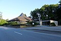
Turquoise mill
|
Turquoise mill
Nohfelden municipality
|
||
|---|---|---|
 |
||
| Height : | 372 m above sea level NHN | |
| Area : | 3.52 km² | |
| Residents : | 732 (Jan 2012) | |
| Population density : | 208 inhabitants / km² | |
| Incorporation : | 1st January 1974 | |
| Postal code : | 66625 | |
| Area code : | 06852 | |
Location of Türkismühle in Saarland |
||

Türkismühle is a district of the municipality of Nohfelden in Saarland with around 730 inhabitants. With the station Türkismühle the Nahe Valley Railway and the junction 3 Nohfelden-Türkismühle the A62 the site is connected to the national transport network. Due to its border location in the north of the Saarland , the place experienced a checkered history of territorial affiliations and as a border town.
history
In 1747 the miller Johann Jacob Dürck built a grinding and oil mill below the confluence of the Söterbach in the Nahe , which was popularly known as the "turquoise mill ". The area was part of the historic Duchy of Pfalz-Zweibrücken . From 1792 this came under French rule ( Département de la Sarre ) along with the entire left bank of the Rhine . After decisions at the Congress of Vienna , the area belonged to the Oldenburg Principality of Birkenfeld from 1817 .
After the construction of the Türkismühle station on the Nahe Valley Railway in 1860, Türkismühle developed into a place. With the commissioning of the Hochwaldbahn from Trier via Hermeskeil to Türkismühle in 1889, the Türkismühle station became a traffic junction. From 1919 the Deutsche Reichsbahn built a railway settlement . These buildings still shape the townscape today.
After the First World War , a border and customs post between the German Reich and the Saar area , which was separated from it from 1920 to 1935 , was set up in Türkismühle . In 1934 the first section of the Türkismühle – Kusel railway from Türkismühle to Wolfersweiler was opened. In 1937 the district of Birkenfeld was dissolved by the Greater Hamburg Law , the region went to Prussia and became part of the Birkenfeld district in the Rhine Province .
After the Second World War , Türkismühle belonged to the French occupation zone . The Saarland was spun off from this in February 1946 ( Saarland 1947 to 1956 ). In July of that year, by order of the French military government, Türkismühle was annexed to Saarland together with other municipalities and part of the Saarland district of St. Wendel . By ordinance of August 21, 1946, the place was spun off from the municipality of Nohfelden and became an independent municipality with effect from September 1, 1946. During this time, Türkismühle was again a border station until the Saarland joined the Federal Republic of Germany in 1957 .
On January 1, 1974, Türkismühle became part of the municipality of Nohfelden as part of the regional and administrative reform .
Economy and Transport
Türkismühle is by the motorway exit Nohfelden-Türkismühle the A62 and the railway station Türkismühle the Nahe Valley Railway incorporated into the national transport infrastructure.
One of the largest companies in the municipality of Nohfelden, Schmidt Küchen GmbH & Co KG and Schmidt-Küchenstudio Türkismühle GmbH is located here.
In an open pit near Türkismühle, the company Gihl Grubenbetriebe (formerly DAM Deutschland GmbH or formerly Villeroy & Boch ) mines a low- mica rhyolite that was previously traded as "clay rock porphyry". It serves as a raw material for tile and earthenware production and as an additive for glass and porcelain production.
The central location within the community of Nohfelden played a role in the establishment of the Türkismühle school center, today's comprehensive and community school.

Protestant church
St. Ignatius
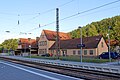
railway station
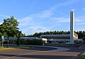
comprehensive school


Museum train
The Hochwaldbahn , which was shut down in 1998 and 2012, was operated as a museum railway between Türkismühle and Hermeskeil until 2012 . In favor of a cycle path, the route was completely dismantled in 2019 (in the Rhineland-Palatinate area) and 2020 (in the Saarland area).
literature
- Literature on turquoise mill in the Saarland bibliography
- Xavier Delamarre, Dictionnaire de la langue gauloise, éditions errance, Paris 2003
Web links
Individual evidence
- ^ Local history of the turquoise mill. Retrieved October 26, 2019 .
- ↑ Official Gazette of the Saar Regional Council No. 42/1946, page 177
- ^ Federal Statistical Office (ed.): Historical municipality directory for the Federal Republic of Germany. Name, border and key number changes in municipalities, counties and administrative districts from May 27, 1970 to December 31, 1982 . W. Kohlhammer, Stuttgart / Mainz 1983, ISBN 3-17-003263-1 , p. 810 . ( Official Journal )
- ↑ Toni König: On the upper Nahe - geological considerations . In the St. Wendeler Land, XIII. Edition 1973, An Nahe, Freis- and Söterbach