
Wolfersweiler
|
Wolfersweiler
Nohfelden municipality
|
||
|---|---|---|
 |
||
| Height : | 375 m above sea level NN | |
| Residents : | 1017 (Jan 2012) | |
| Incorporation : | 1st January 1974 | |
| Postal code : | 66625 | |
| Area code : | 06852 | |
Location of Wolfersweiler in Saarland |
||
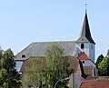
 View of Wolfersweiler
|
||


Wolfersweiler is a district of the municipality of Nohfelden ( St. Wendel district ) in the northeastern Saarland . The place has about 1100 inhabitants and is located in the Saar-Hunsrück Nature Park . The B 41 leads through the village.
history
Prehistory and early history
A picture of Wolfersweiler before it was first mentioned in a document, i.e. the picture of prehistory and early history, as well as that of the early Middle Ages, has to be obtained through archeology. Archaeological finds from these epochs have been documented in the vicinity of Wolfersweiler, as evidence of a settlement of the Wolfersweiler Bann before it was first mentioned in a document. Most of the archaeological finds come from prehistory and early history, from the tumuli (barrows), in which numerous pieces of jewelery from the Iron Age (more precisely Hallstatt and Latène times) have been found. In the immediate vicinity of the tumuli, a fountain has been preserved, the so-called knife fountain, the area of which is referred to on the map as “Am Messerborn”, which is interpreted as follows in the field names: “Former name Messeborn, fair = church or market; fundamental interpretation still open ”, in another part of the book it is translated from Latin, namely from Latin messis = the harvest or Roman mansus = hooves, also Latin mansio = yard, house from the fact that the“ knife born ”is a Hofborn, Hofbrunnen was. This fountain was already used for ritual purposes in the times of the Celts, this is assumed because statues of Roman and Celtic gods, a statue of the Roman god Apollo and a statue of the Celtic Sirona were found in the immediate vicinity of the fountain.
A large part of life took place around this well, which the Romans expanded into a spring sanctuary. According to the history of the village , craftsmen, farriers and innkeepers are said to have settled at a fork in the immediate vicinity . Today we know that there were no houses in the fields at the fork in the road. This came out from a geomagnetic survey on February 23, 2009. At the same time, an elevation was found in the forest to the left of the well, which could have come from a house from bygone eras, as larger hewn stones were also found there. On the Wolfersweiler Bann there was a ring wall on the Homerich. A large part of the ramparts, some of which were used for protection, as refuges, were built in the period from 500–300 BC (Latène period), and the Wolfersweiler ring wall may have been built during this time. It is possible that it was not a refuge, but a high tower that monitored the Roman road Birkenfeld - Sankt Wendel and the Novallis Castle.
Some of the field names of the Wolfersweiler Bann are reminiscent of a prehistoric and early historical settlement of the Wolfersweiler district, for example hall 29, which bears the field name "Auf Dem Allhopp", which means something like "old farm". A Roman villa is said to have stood there. Sandstone blocks with fragments of indistinguishable Latin inscriptions were walled into a farmhouse from her. The street name Zum Allhopp is reminiscent of this Roman villa.
middle Ages
Novallis Castle (probably from the 10th / 11th century), of which only a few remains of building blocks, a cistern and a driveway in the form of an avenue, have been preserved, was mainly used to monitor and secure the pre-Roman road Birkenfeld - Sankt Wendel (such as the Ringwall on the Homerich). The castle was the bridgehead of the great Verdun manor district Wolfersweiler - Baumholder. The first mention of Novallis Castle is firmly dated, the then Archbishop of Verdun, feudal lord and owner of Novallis Castle, stopped at the castle on June 24, 1066 when he followed the new Archbishop of Trier, who had been murdered by the Trier lords Verdun convicted. The location of Novallis Castle also has a field name, the hill on which the castle stood is called Schlossberg. This is said to have been a mansion, in this case that of the diocese of Verdun. The reason why Novallis Castle fell in ruins is unknown. There are some legends about Novallis Castle. One of them says that after the death of the Franconian builders, the so-called "beet knights" were up to mischief in the castle and expelled the daughters of the Franks from the castle. The "beet knights" occupied the castle and from there they went about their "robber and thief trade". So one can assume that the "Lords of Oberstein, Eberhard von Stein and Wirich von Daun" were the robber barons, because they wanted to expand their territorial estates at the expense of the Verdun estates in Wolfersweiler and Baumholder. This can only be assumed, however, because there are some indications that speak against it, Eberhard Ritter von Stein is said to have returned the yards and bans of Wolfersweiler and Baumholder to the archbishop of Verdun's complaints. The fact is that one cannot say that Novallis Castle belonged to Wolfersweiler, but rather that it had its own spell, because as a rule a village belongs to a castle and not a castle to a village. On the other hand, there are again indications that speak for it, because in 1251 Everhard vom Stein and his son are supposed to reimburse the Archbishop of Verdun for their damage worth 200 Trier pounds. Because of this high sum, one can assume that the Lords of Stein were the reasons why the castle fell into desolation. They destroyed the castle and used the fogged stones to build Navelden Castle. The castle was completed on December 30, 1285. This newly built Navelden Castle was the castle of knight Wilhelm Bossel vom Steine.
Origin of the village
The village of Wolfersweiler probably emerged from a Franconian settlement, because village names ending in -ingen, -heim, -dorf and -weiler originated between the 5th and 8th centuries. Proof that Wolfersweiler was created during this time is a church bell that was melted down during the National Socialist era. This church bell is said to have been donated by Charlemagne, between 768 and 814. The bell was to be used to call Christians together for worship. This means that the diocese of Verdun had ecclesiastical supervision in Wolfersweiler at the latest in the 7th century, which was confirmed in the Verdun fiefdom in the 12th century, in which it is stated that Wolfersweiler and the surrounding villages were in the hands of the Count of Veldenz were. The Archbishop of Verdun was the owner and feudal lord until 1327, the church in the Wolfersweiler parish was in the hands of the Counts of Homburg as a fief of the Diocese of Verdun, and the manor was in the hands of the Counts of Veldenz. In 1327, in return for payment of an annual fee, all inclines with all jurisdiction and accessories were transferred to the Count of Veldenz, the Archbishop of Verdun was only the formal owner of Wolfersweiler. Wolfersweiler remained in the hands of Count von Veldenz until 1444 when Count Friedrich III died, his son-in-law Stephan was given the county, and he also acquired "areas around Zweibrücken, on the Hunsrück, in the Front Palatinate and in Alsace" through inheritance. This is how the Duchy of Zweibrücken came into being, which existed until the French Revolution, and the Wolfersweiler area also belonged to this duchy.
Jurisdiction and Guilds
The district court, as the highest instance, was always held by the Counts of Veldenz, and later by the Count Palatine. The lower jurisdiction was largely divided between the territorial rulers, the lower jurisdiction differed from the high jurisdiction, the count was responsible for the height of the mayor for the lower jurisdiction. The lower court had seven, the high court had 14 lay judges. Based on the records of Wolfersweiler's jurisdiction, in which it is written that they had 14 lay judges, one can conclude that a high court had its seat in Wolfersweiler. The jurisdiction of Wolfersweiler was confirmed for the first time in a feudal deed from the Bishop of Verdun to the Count of Veldenz on August 23, 1235. The mayor's shop was subordinate to the Oberamt Lichtenberg and belonged to the Amt Nohfelden founded in 1480. Wolfersweiler was the center of a large parish and a mayor's shop with the seat of five different craft guilds, the building and hammer guild, the baker, butcher and cooper guild, the miller's guild, the shoemaker and red tanner guild and the tailor, linen and wool weaver guild. In 1731 the imperial law required that all wandering craftsmen had to have travel documents or work references; this law also caused the small guilds in rural areas to have a seal made for themselves.
The parish
The development of the aforementioned “large parish” was already completed in the 9th century, with the demarcation between the dioceses of Mainz and Trier. It can be assumed that the Wolfersweiler parish was established in the 8th century at the latest, due to the church bell donated by Charlemagne (768–814). Wolfersweiler was one of the three large parishes that arose in the Tholeyer baptismal district. The Wolfersweiler parish was responsible for the north of the area. The Wolfersweiler parish alone contained sixteen villages in 1580 that had to pay their taxes / tithes to the Wörschweiler monastery . For some residents of Wolfersweiler, this regulation of the tithe law certainly caused problems in their own provision, especially since the residents had to pay additional taxes to their liege lords due to the feudal system, which in some cases led to famine and impoverishment in Europe.
reformation
Under Duke Ludwig II, the age of the Reformation came to Wolfersweiler when he accepted the preacher Johannes Schwebel to his court. Long before it was decided in the Speyer Reichstag in 1526 to allow the Protestant form of worship, this form of worship was already held in Wolfersweiler. Changes were, "... that at the Lord's Supper both bread and wine were distributed to the communicates, the mass was held in German and ... the pastors married".
At the behest of Count Palatine Ruprecht, who took over the guardianship and government until 1543, until the son of the late Duke Ludwig II was of legal age, the aforementioned preacher Schwebel drafted a first church ordinance in which church life was regulated with 12 articles. These rules had to be established, for this reason visitations were carried out regularly. In 1555, the religious peace took place in Augsburg, that is, the various counties, duchies, ... were free to decide which denomination they wanted to belong to, so the area Palatinate - Zweibrücken, under Duke Wolfgang, who in 1557 a new church order issued, Lutheran, this form of worship became mandatory in the parishes and was also checked by visitations.
The Thirty-Year War
The Duchy of Pfalz-Zweibrücken declared itself in 1608 to the "political union of Protestant imperial estates", the Catholics had an opposing union, the League. The “Thirty Years War” can be divided into two parts, the religious war between the Catholic League and the Evangelical Union and the European war on German soil. The war broke out in 1618 due to the “Prague lintel” and ended in 1648 when the Westphalian peace was concluded in Münster and Osnabrück. When France entered the war in 1635 to prevent the Habsburgs from encircling its territories, this had serious consequences for our surroundings. The French advanced as far as Mainz, but could not hold their position and had to withdraw
“... via Kreuznach, Sobernheim, Birkenfeld and Wallerfangen to the Saar. These campaigns then brought the whole misery of the Thirty Years War with the marauding and plundering mercenary gangs over our area ”.
After the war, 33 of 154 households remained. In the area of the Wolfersweiler parish, as in numerous other cities in the country, settlements were wiped out at the expense of the “Thirty Years War” and turned into so-called devastation. Wolfersweiler was unable to recover after the Thirty Years' War due to subsequent wars. Protection troops were formed that were supposed to protect the population from looters, but in many cases joined forces with them. These times had devastating consequences for the Wolfersweiler parish, which was once a large parish and became one of the poorest parishes. When the Palatinate - Zweibrücker Duchy came into the hands of the Swedish kings in 1681 and these were Lutheran, they encouraged the settlement of Lutheran residents. However, our country could not recover for long, because between the 17th and 18th centuries there were further wars, led by King Louis XIV, the so-called Sun King, who wanted to secure his supremacy in Europe and thus affected our region. When the Sun King had to surrender the German lands again in the Peace of Rijswijk in 1697, our area still did not find peace, only after the War of the Spanish Succession and the Peace of Utrecht in 1715, new settlers could be recruited, who were promised great financial relief and freedom of religion .
The French revolution
With the French Revolution in 1789, armies came back to our homeland with their war loads, looting and desecration. Only the peace of Campo Formio of October 1797 brought peace to our homeland. Since the French Empire had spread to the left bank of the Rhine ,
“... four new departments were created. Our area came to the Département de la Sarre . These departments were in turn divided into arrondisments, these were divided into cantons and the smaller towns were merged into a mairie. "
Wolfersweiler belonged to the canton Baumholder . Through this division, the different places of the parish Wolfersweiler and the high court were torn apart politically. This conflict lasted until the Congress of Vienna , when Europe was reorganized after the fall of Napoleon. At the Congress of Vienna Wolfersweiler came into the hands of the Grand Duke of Oldenburg, since Prussia was obliged to
"... to leave an area with 20,000 souls to the Grand Duke of Oldenburg as compensation for war burdens."
This area, which the Grand Duke received, which stretched from Bundenbach in the north to Hirstein in the south, he called the Principality of Birkenfeld .
At the end of the 1820s and between 1840 and 1860 there were crop failures and famine, which prompted many people to emigrate and seek their fortune in America. Around 120 families emigrated from Wolfersweiler alone between 1733 and 1890.
First and Second World War
After the First World War, in which 27 men from Wolfersweiler died, the Oldenburg Grand Duke Friedrich August renounced the throne. The Principality of Birkenfeld was now part of the Birkenfeld state of the Free State of Oldenburg.
In July 1938, a bunker system for the air defense was built in Wolfersweiler as part of the West Air Defense Zone. The construction plans were top secret, the residents of Wolfersweiler were not allowed to stay near the construction sites if they did not have a residence permit. When the bunkers were completed in the summer of 1939, the Wehrmacht moved in in November of the same year. The Wehrmacht used the bunkers for maneuvering purposes in order to prepare for the French campaign.
Latest time
On January 1, 1974, Wolfersweiler was incorporated into the community of Nohfelden.
In 2006 Wolfersweiler celebrated its 850th anniversary. This was celebrated with a large three-day festival - the climax of which was a parade of 80 groups.
The annual Laurentius fair is one of the highlights. This folk festival in honor of the patron saint is celebrated every year on the second weekend in August. The large tent and the festival area on Römerstrasse attract several thousand visitors every year. The Laurentiuskirmes is one of the largest folk festivals in northern Saarland and the neighboring Rhineland-Palatinate.
politics
The current mayor is Eckhard Heylmann ( SPD ).
Attractions
Protestant church
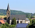
Catholic Church


- Evangelical church , built from 1786 to 1788 according to the plan by Friedrich Gerhard Wahl , late Gothic tower (dated in the entablature 1586), with a historical Stumm organ from 1834, cast bell in 1826, according to the inscription supposedly a foundation of Charlemagne
- Catholic Church of St. Laurentius , built in 1867/68 in neo-Romanesque style.
traffic
The station Wolfersweiler was on the railway line Türkismühle-Kusel . The passenger Türkismühle - Freisen was discontinued on June 1, 1969th
literature
- Achim Fries et al .: 850 years of Wolfersweiler. 1156-2006 . A little village story . Wolfersweiler 2005.
- Literature about Wolfersweiler in the Saarland Bibliography
Web links
Individual evidence
- ↑ Homepage of the municipality of Nohfelden
- ^ Federal Statistical Office (ed.): Historical municipality directory for the Federal Republic of Germany. Name, border and key number changes in municipalities, counties and administrative districts from May 27, 1970 to December 31, 1982 . W. Kohlhammer, Stuttgart / Mainz 1983, ISBN 3-17-003263-1 , p. 810 .
- ↑ DB Netz - Transfer of Railway Infrastructure | Route no.3201 from Türkismühle to Wolfersweiler ( memento from March 22, 2017 in the Internet Archive ), accessed on March 21, 2017