
Mettweiler
| coat of arms | Germany map | |
|---|---|---|

|
Coordinates: 49 ° 35 ' N , 7 ° 19' E |
|
| Basic data | ||
| State : | Rhineland-Palatinate | |
| County : | Birch field | |
| Association municipality : | Baumholder | |
| Height : | 445 m above sea level NHN | |
| Area : | 5.49 km 2 | |
| Residents: | 236 (Dec. 31, 2019) | |
| Population density : | 43 inhabitants per km 2 | |
| Postal code : | 55777 | |
| Area code : | 06783 | |
| License plate : | BIR | |
| Community key : | 07 1 34 054 | |
| Association administration address: | Am Weiherdamm 1 55774 Baumholder |
|
| Website : | ||
| Mayoress : | Ute Theiss | |
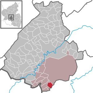
| Location of the local community of Mettweiler in the Birkenfeld district | ||
  |
||

Mettweiler is a municipality in the Birkenfeld district in Rhineland-Palatinate . It belongs to the Baumholder community .
geography
The local community Mettweiler belongs to the Westrich . In the north is the town of Baumholder , in the southeast the local community Thallichtenberg and to the west are the local community Berschweiler bei Baumholder and the local community Fohren-Linden . In Mettweiler, 47 percent of the municipal area is forested.
history
Until the end of the 18th century, the place belonged to the part of the Duchy of Palatinate-Zweibrücken, which came from the County of Veldenz , and was assigned to the Berschweiler mayor in the Oberamt Lichtenberg . In 1790 there were 42 families in the village. The district of Mettweiler covered 550 hectares .
In 1794 the Left Bank of the Rhine was taken by French revolutionary troops. From 1798 to 1814 Mettweiler belonged to the canton Baumholder in the Saardepartement . Due to the agreements reached at the Congress of Vienna (1815), the region came to the Saxon-Coburg principality of Lichtenberg in 1816 , to which it belonged until 1834. The community of Mettweiler initially belonged to the mayor's office of Berschweiler , from 1823 to the mayor's office of Burglichtenberg (see also the list of municipalities in the Principality of Lichtenberg ). After the sale to Prussia and the dissolution of the Principality of Lichtenberg, Mettweiler came to the newly established St. Wendel district in the Rhine province . Mettweiler has been part of the Birkenfeld district since 1937 and part of the state of Rhineland-Palatinate since 1946 .
- Population development
The development of the population of Mettweiler, the values from 1871 to 1987 are based on censuses:
|
|
politics
Municipal council
The council in Mettweiler consists of six council members, who in the local elections on May 26, 2019 in a majority vote were elected, and the honorary mayor as chairman.
coat of arms
The blue lion refers to the former belonging to the county of Veldenz .
Culture and sights
The fountain festival and the fair are held annually. The sports club also organizes a carnival event.
Economy and Infrastructure
The federal motorway 62 runs to the south .
In the local community Heimbach (Birkenfeld district) is a train station on the Bingen – Saarbrücken line .
Web links
- Local community Mettweiler on the website of the Baumholder community
- Literature about Mettweiler in the Rhineland-Palatinate state bibliography
Individual evidence
- ↑ a b State Statistical Office of Rhineland-Palatinate - population status 2019, districts, municipalities, association communities ( help on this ).
- ↑ a b State Statistical Office Rhineland-Palatinate - regional data
- ^ Wilhelm Fabricius : Explanations of the Historical Atlas of the Rhine Province, Die Karte von 1789 (2nd volume), Bonn 1898. S. 400
- ^ The Regional Returning Officer Rhineland-Palatinate: Local elections 2019, city and municipal council elections

Adventure | Achtelsbach | Allenbach | Asbach | Baumholder | Mountains | Berglangenbach | Berschweiler at Baumholder | Berschweiler near Kirn | Birkenfeld | Bollenbach | Börfink | Breitenthal | Bruchweiler | Bridges | Buhlenberg | Bundenbach | Dambach | Dickesbach | Dienstweiler | Eckersweiler | Elkweiler | Ellenberg | Ellweiler | Fischbach | Fohren-Linden | Frauenberg | Gerach | Gimbweiler | Gollenberg | Gösenroth | Griebelschied | Hahnweiler | Hattgenstein | Hausen | Heimbach | Hellertshausen | Herborn | Herrstein | Hettenrodt | Hintertiefenbach | Hoppstädten-Weiersbach | Horbruch | Hottenbach | Idar-Oberstein | Kempfeld | Kirschweiler | Kronweiler | Krummenau | Boring | Leisel | Leitzweiler | Mackenrodt | Meckenbach | Mettweiler | Mittelreidenbach | Mörschied | Niederbrombach | Niederhambach | Niederhosenbach | Niederwörresbach | Nohen | Oberbrombach | Oberhambach | Oberhosenbach | Upper brain | Oberreidenbach | Oberwörresbach | Reichenbach | Rhaunen | Rimsberg | Rinzenberg | Rohrbach | Rötsweiler-Nockenthal | Rückweiler | Ruschberg | Showers | Schmidthachenbach | Schmissberg | Schwerbach | Swelling | Sensweiler | Sien | Sienhachenbach | Siesbach | Sonnenberg-Winnenberg | Sonnschied | Stipshausen | Sulzbach | Veitsrodt | Vollmersbach | Pastures | Weitersbach | Wickenrodt | Wilzenberg-Hussweiler | Wirschweiler