
Achtelsbach
| coat of arms | Germany map | |
|---|---|---|

|
Coordinates: 49 ° 38 ' N , 7 ° 5' E |
|
| Basic data | ||
| State : | Rhineland-Palatinate | |
| County : | Birch field | |
| Association municipality : | Birch field | |
| Height : | 403 m above sea level NHN | |
| Area : | 9.7 km 2 | |
| Residents: | 399 (Dec. 31, 2019) | |
| Population density : | 41 inhabitants per km 2 | |
| Postal code : | 55767 | |
| Area code : | 06782 | |
| License plate : | BIR | |
| Community key : | 07 1 34 002 | |
| LOCODE : | DE ACA | |
| Association administration address: | Schneewiesenstrasse 21 55765 Birkenfeld |
|
| Website : | ||
| Local Mayor : | Kai Sohns | |
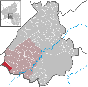
| Location of the community of Achtelsbach in the Birkenfeld district | ||
  |
||

Achtelsbach is a municipality in the Birkenfeld district in Rhineland-Palatinate . It belongs to the Birkenfeld community and is located about 6 km west of the district town of the same name . Idar-Oberstein is 22 km northeast, St. Wendel around 25 km south of Achtelsbach.
geography
The place is on the Traunbach , at the foot of the Black Forest high forest . To the south and north of the village are wooded mountains of 525 and 500 m above sea level. The state border with Saarland runs immediately to the west of the town . Achtelsbach's neighboring towns are Brücken , Traunen, Meckenbach and the Saarland town of Eisen (municipality of Nohfelden , district of St. Wendel ).
The Forsthaus Neuhof residential area also belongs to Achtelsbach .
Achtelsbach is a national park community in the Hunsrück-Hochwald National Park .
history
Achtelsbach was first mentioned in 1256 as Achtelsbach . Already in the following decades it acquired a center function for the surrounding towns and in 1315 it became the seat of a nursing home that, in addition to Achtelsbach, also administered the neighboring villages of Dambach , Meckenbach and Trauen . This care was initially under the rule of the bailiffs of Hunolstein as an after-fief of Trier . This rule was ended in 1480 when the Duke of Zweibrücken sent his own mayor to Achtelsbach. The territory of the care Achtelsbach was extended to include the place Ellweiler and from the end of the 18th century to the places Eisen and Eckelhausen . In the course of the takeover of the Left Bank of the Rhine by French troops after the local revolution , Achtelsbach became the capital of a Mairie in the canton of Birkenfeld , which existed as Oldenburg mayor until 1876 after 1817 .
The parish of Achtelsbach was originally congruent with the maintenance until the villages of Brücken and Abentheuer were added. It lost its influence after the Reformation and was ceded to Birkenfeld and Sötern . There is evidence of a pastor in the church, which was consecrated to St. Ulrich in Achtelsbach, since 1334, but its origins are older. This church, evangelical since the 16th century, with the steeple that characterizes the townscape, is the most striking building in the town today. In 1922 a bell from Achtelsbach, dated 1466, was acquired for the church there in Wickenrodt . On January 9, 2010, the bell tower and the entire church were badly damaged in a fire.
Population development
The development of the population of Achtelsbach, the values from 1871 to 1987 are based on censuses:
|
|

politics
Municipal council
The council in Achtelsbach consists of eight council members, who in the local elections on May 26, 2019 in a majority vote were elected, and the honorary mayor as chairman.
coat of arms
|
|
Blazon : "In a divided shield above in silver a red, six-petalled rose with golden clusters, below a growing, red-crowned, armored and tongued golden lion in black."
It was approved by the Rhineland-Palatinate Ministry of the Interior in 1965. |
Economy and Infrastructure
traffic
Achtelsbach has no rail connection. The next train station is seven kilometers southeast in Neubrücke on the Nahe Valley Railway . There are road connections to Birkenfeld, to Nonnweiler in the Saarland and to Hermeskeil beyond the high forest. The A 62 ( Kaiserslautern - Trier ) runs around five kilometers south of Achtelsbach, junction points are in Neubrücke and Nohfelden-Türkismühle. The federal highways 41 and 269 run from Birkenfeld to Neubrücke a few kilometers east of Achtelsbach.
Landheim Achtelsbach
The former Boy Scout Country Home of the Association of Boy Scouts from Idar-Oberstein was taken over by the municipality of Achtelsbach in May 2011. The country home in Achtelsbach will continue to be offered as a youth and leisure center and rented out to self-caterers.
Born in Achtelsbach
- Heinz Lueg (1914–1984), German electrical engineer and university professor
See also
literature
- Alfred Eiler: Achtelsbach history of a home ; Achtelsbach: Community of Achtelsbach, 2000
- Manfred Haas: family book Achtelsbach from 1799 ; Evangelical parish in Achtelsbach / Brücken 2011
- Literature about Achtelsbach in the Rhineland-Palatinate State Bibliography
Web links
- Homepage of the community of Achtelsbach
- Local community Achtelsbach on the website of the Verbandsgemeinde Birkenfeld
- Brief portrait of Achtelsbach near Hierzuland , SWR television .
Individual evidence
- ↑ State Statistical Office of Rhineland-Palatinate - population status 2019, districts, communities, association communities ( help on this ).
- ↑ State Statistical Office Rhineland-Palatinate (ed.): Official directory of the municipalities and parts of the municipality. Status: January 2019 [ Version 2020 is available. ] . S. 28 (PDF; 3 MB).
- ^ Wilhelm Fabricius : Explanations of the Historical Atlas of the Rhine Province, The map of 1789 (2nd volume), Bonn 1898. P. 404
- ↑ www.allgemeine-zeitung.de ( Memento from July 23, 2011 in the Internet Archive ). Retrieved January 9, 2010.
- ↑ State Statistical Office Rhineland-Palatinate - regional data

Adventure | Achtelsbach | Allenbach | Asbach | Baumholder | Mountains | Berglangenbach | Berschweiler at Baumholder | Berschweiler near Kirn | Birkenfeld | Bollenbach | Börfink | Breitenthal | Bruchweiler | Bridges | Buhlenberg | Bundenbach | Dambach | Dickesbach | Dienstweiler | Eckersweiler | Elkweiler | Ellenberg | Ellweiler | Fischbach | Fohren-Linden | Frauenberg | Gerach | Gimbweiler | Gollenberg | Gösenroth | Griebelschied | Hahnweiler | Hattgenstein | Hausen | Heimbach | Hellertshausen | Herborn | Herrstein | Hettenrodt | Hintertiefenbach | Hoppstädten-Weiersbach | Horbruch | Hottenbach | Idar-Oberstein | Kempfeld | Kirschweiler | Kronweiler | Krummenau | Boring | Leisel | Leitzweiler | Mackenrodt | Meckenbach | Mettweiler | Mittelreidenbach | Mörschied | Niederbrombach | Niederhambach | Niederhosenbach | Niederwörresbach | Nohen | Oberbrombach | Oberhambach | Oberhosenbach | Upper brain | Oberreidenbach | Oberwörresbach | Reichenbach | Rhaunen | Rimsberg | Rinzenberg | Rohrbach | Rötsweiler-Nockenthal | Rückweiler | Ruschberg | Showers | Schmidthachenbach | Schmissberg | Schwerbach | Swelling | Sensweiler | Sien | Sienhachenbach | Siesbach | Sonnenberg-Winnenberg | Sonnschied | Stipshausen | Sulzbach | Veitsrodt | Vollmersbach | Pastures | Weitersbach | Wickenrodt | Wilzenberg-Hussweiler | Wirschweiler