
Reichenbach (near Baumholder)
| coat of arms | Germany map | |
|---|---|---|
_COA.svg)
|
Coordinates: 49 ° 38 ' N , 7 ° 17' E |
|
| Basic data | ||
| State : | Rhineland-Palatinate | |
| County : | Birch field | |
| Association municipality : | Baumholder | |
| Height : | 413 m above sea level NHN | |
| Area : | 11.12 km 2 | |
| Residents: | 550 (Dec. 31, 2019) | |
| Population density : | 49 inhabitants per km 2 | |
| Postal code : | 55776 | |
| Area code : | 06783 | |
| License plate : | BIR | |
| Community key : | 07 1 34 068 | |
| Association administration address: | Am Weiherdamm 1 55774 Baumholder |
|
| Website : | ||
| Local Mayor : | Olaf Schmidt | |
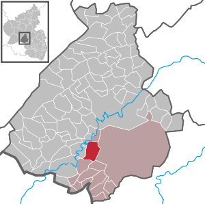
| Location of the local community Reichenbach in the Birkenfeld district | ||
  |
||

Reichenbach is a municipality in the Birkenfeld district in Rhineland-Palatinate . It belongs to the Baumholder community .
geography
The place is located on the Reichenbach stream of the same name, west of the 563 meter high Feldberg. 37.5 percent of the district area is forested.
The town and the Baumholder military training area are to the east, Ruschberg to the south, Nohen and Kronweiler to the west and Frauenberg to the north .
The Richtmannsmühle, Reichenbacherhöfe and Sonnenhof residential areas also belong to Reichenbach.
history
Reichenbach belonged to the late 18th century to the Rear County of Sponheim and the was Oberamt Birkenfeld belonging Care Rimsberg assigned. In 1607 32 families were counted in Reichenbach, in 1699 there were only 14, the number of which rose to 66 by 1772. In 1790 the place had 233 inhabitants, the district of Reichenbach comprised 1084 hectares .
In 1794 the Left Bank of the Rhine was taken by French revolutionary troops. From 1798 to 1814 Reichenbach belonged to the canton Baumholder in the Saardepartement . Due to the agreements reached at the Congress of Vienna (1815), the region came to the Saxon-Coburg principality of Lichtenberg in 1816 , to which it belonged until 1834. The municipality of Reichenbach became the seat of a mayor's office in 1817, which also included the municipalities of Aulenbach , Ausweiler , Frauenberg , Hammerstein and Ruschberg (see also the list of municipalities in the Principality of Lichtenberg ). This administrative district was dissolved in 1823 and integrated into the Baumholder mayor . After the sale to Prussia and the dissolution of the Principality of Lichtenberg, Reichenbach came to the newly established St. Wendel district in the Rhine province . Reichenbach has been part of the Birkenfeld district since 1937 and part of the state of Rhineland-Palatinate since 1946 .
- Population development
The development of the population of Reichenbach, the values from 1871 to 1987 are based on censuses:
|
|
politics
Municipal council
The council in Reichenbach consists of twelve council members, who in the local elections on May 26, 2019 in a majority vote were elected, and the honorary mayor as chairman.
coat of arms
The checkerboard pattern refers to the former belonging to the county of Sponheim .
Economy and Infrastructure
The federal motorway 62 runs to the south .
In Nohen there is a train station on the Bingen – Saarbrücken line .
See also
Web links
- Reichenbach municipality
- Reichenbach community on the website of the Baumholder community
- Literature about Reichenbach in the Rhineland-Palatinate State Bibliography
Individual evidence
- ↑ a b State Statistical Office of Rhineland-Palatinate - population status 2019, districts, municipalities, association communities ( help on this ).
- ↑ State Statistical Office Rhineland-Palatinate (ed.): Official directory of the municipalities and parts of the municipality. Status: January 1, 2017 [ Version 2020 is available. ] . S. 18 (PDF; 1.9 MB).
- ^ Wilhelm Fabricius : Explanations of the Historical Atlas of the Rhine Province, Die Karte von 1789 (2nd volume), Bonn 1898. P. 443, 456
- ↑ State Statistical Office Rhineland-Palatinate - regional data
- ^ The Regional Returning Officer Rhineland-Palatinate: Local elections 2019, city and municipal council elections

Adventure | Achtelsbach | Allenbach | Asbach | Baumholder | Mountains | Berglangenbach | Berschweiler at Baumholder | Berschweiler near Kirn | Birkenfeld | Bollenbach | Börfink | Breitenthal | Bruchweiler | Bridges | Buhlenberg | Bundenbach | Dambach | Dickesbach | Dienstweiler | Eckersweiler | Elkweiler | Ellenberg | Ellweiler | Fischbach | Fohren-Linden | Frauenberg | Gerach | Gimbweiler | Gollenberg | Gösenroth | Griebelschied | Hahnweiler | Hattgenstein | Hausen | Heimbach | Hellertshausen | Herborn | Herrstein | Hettenrodt | Hintertiefenbach | Hoppstädten-Weiersbach | Horbruch | Hottenbach | Idar-Oberstein | Kempfeld | Kirschweiler | Kronweiler | Krummenau | Boring | Leisel | Leitzweiler | Mackenrodt | Meckenbach | Mettweiler | Mittelreidenbach | Mörschied | Niederbrombach | Niederhambach | Niederhosenbach | Niederwörresbach | Nohen | Oberbrombach | Oberhambach | Oberhosenbach | Upper brain | Oberreidenbach | Oberwörresbach | Reichenbach | Rhaunen | Rimsberg | Rinzenberg | Rohrbach | Rötsweiler-Nockenthal | Rückweiler | Ruschberg | Showers | Schmidthachenbach | Schmissberg | Schwerbach | Swelling | Sensweiler | Sien | Sienhachenbach | Siesbach | Sonnenberg-Winnenberg | Sonnschied | Stipshausen | Sulzbach | Veitsrodt | Vollmersbach | Pastures | Weitersbach | Wickenrodt | Wilzenberg-Hussweiler | Wirschweiler