
Gosenroth
| coat of arms | Germany map | |
|---|---|---|

|
Coordinates: 49 ° 53 ' N , 7 ° 20' E |
|
| Basic data | ||
| State : | Rhineland-Palatinate | |
| County : | Birch field | |
| Association municipality : | Herrstein-Rhaunen | |
| Height : | 430 m above sea level NHN | |
| Area : | 4.49 km 2 | |
| Residents: | 237 (Dec. 31, 2019) | |
| Population density : | 53 inhabitants per km 2 | |
| Postal code : | 55624 | |
| Area code : | 06544 | |
| License plate : | BIR | |
| Community key : | 07 1 34 030 | |
| Association administration address: | Brühlstrasse 16 55756 Herrstein |
|
| Website : | ||
| Local Mayor : | Albert Echternacht | |
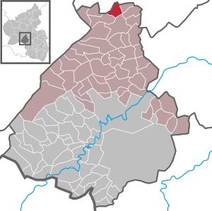
| Location of the local community of Gösenroth in the Birkenfeld district | ||
  |
||


Gösenroth is a municipality in the Birkenfeld district in Rhineland-Palatinate . It belongs to the Herrstein-Rhaunen community .
geography
Gösenroth is a street village in the Hunsrück east of the Idarwald . In the east is the Kyrbachtal . Neighboring towns are Laufersweiler , Schwerbach , Rhaunen and Weitersbach .
history
The oldest finds, which indicate a settlement on today's Gösenrother district, date from the first and the beginning of the second century after the birth of Christ. This is indicated by the finds made by the Trier State Museum in 1936 on the road between Gösenroth and Schwerbach (bordering the Laufersweiler district). When clearing the forest, seven barrows were discovered, and when they were opened, an iron ax, several amphora, pots, urns, a spinning mirtle, a pair of fibulae, two coins (one with the image of Nero from 64 to 68) and a bronze bracelet came to light. In the youngest grave (2nd century AD) an iron writing pen was discovered. Remains of a dwelling were also suspected.
Popularly known as "Gesad", the place name developed from Gitzad , Gossenroth , Goesenrat , Goisenrait and Gossenrait to Gösenroth. The meaning of the name is unclear. The ending -roth is of Franconian origin and indicates the emergence around the turn of the millennium through clearing .
On May 5, 1367, the lords of Senheim were mentioned as lords of the place. On June 14, 1464, Wilhelm Vogt von Senheim and his sister Eva von Senheim, who was married to Werner von Löwenstein, ceded the town of Goisenrait to the Wild and Rhine Counts .
On the old route between Rhaunen and Hochscheid (field name Gonsenbach), remnants of a desert could still be seen until 1938 . In 1429 this is called the Batzerter Hof owned by Bechtolff von Sötern.
The oldest surviving building is the Hof (Giehl) built by Rheingraf Ludwig Wilhelm in 1654. The so-called foot mill, which has been restored in recent years and is fully functional, used to belong to Dill Castle . The Protestant church was built in 1844/45 in place of a smaller chapel and consecrated in 1848.
Population development
The development of the population of Gösenroth, the values from 1871 to 1987 are based on censuses:
|
|
religion
Around 176 Gösenroths make up the Evangelical Church Community of Gösenroth, which is connected to Büchenbeuren through the parish. It belongs to the Simmern-Trarbach parish .
politics
Municipal council
The council in Gösenroth consists of six council members, who in the local elections on May 26, 2019 in a majority vote were elected, and the honorary mayor as chairman.
mayor
Albert Echternacht became the mayor of Gösenroth in 2009. In the direct election on May 26, 2019, he was confirmed in his office for another five years with a share of the vote of 82.43%.
Economy and Infrastructure
There is a village community center in the village. In Kirn there is a train station on the Bingen – Saarbrücken line . In the north are the federal highway 50 and the Frankfurt-Hahn airport .
See also
Web links
- Local community Gösenroth on the website of the Herrstein-Rhaunen community community
- Literature about Gösenroth in the Rhineland-Palatinate state bibliography
Individual evidence
- ↑ State Statistical Office of Rhineland-Palatinate - population status 2019, districts, communities, association communities ( help on this ).
- ↑ State Statistical Office Rhineland-Palatinate - regional data
- ^ The Regional Returning Officer Rhineland-Palatinate: Local elections 2019, city and municipal council elections
- ^ Runoff elections in the Rhaunen community. In: Trierischer Volksfreund. Volksfreund-Druckerei Nikolaus Koch GmbH, Trier, June 22, 2009, accessed on August 20, 2020 .
- ^ The Regional Returning Officer Rhineland-Palatinate: direct elections 2019. see Herrstein-Rhaunen, Verbandsgemeinde, 13th line of results. Retrieved August 20, 2020 .

Adventure | Achtelsbach | Allenbach | Asbach | Baumholder | Mountains | Berglangenbach | Berschweiler at Baumholder | Berschweiler near Kirn | Birkenfeld | Bollenbach | Börfink | Breitenthal | Bruchweiler | Bridges | Buhlenberg | Bundenbach | Dambach | Dickesbach | Dienstweiler | Eckersweiler | Elkweiler | Ellenberg | Ellweiler | Fischbach | Fohren-Linden | Frauenberg | Gerach | Gimbweiler | Gollenberg | Gösenroth | Griebelschied | Hahnweiler | Hattgenstein | Hausen | Heimbach | Hellertshausen | Herborn | Herrstein | Hettenrodt | Hintertiefenbach | Hoppstädten-Weiersbach | Horbruch | Hottenbach | Idar-Oberstein | Kempfeld | Kirschweiler | Kronweiler | Krummenau | Boring | Leisel | Leitzweiler | Mackenrodt | Meckenbach | Mettweiler | Mittelreidenbach | Mörschied | Niederbrombach | Niederhambach | Niederhosenbach | Niederwörresbach | Nohen | Oberbrombach | Oberhambach | Oberhosenbach | Upper brain | Oberreidenbach | Oberwörresbach | Reichenbach | Rhaunen | Rimsberg | Rinzenberg | Rohrbach | Rötsweiler-Nockenthal | Rückweiler | Ruschberg | Showers | Schmidthachenbach | Schmissberg | Schwerbach | Swelling | Sensweiler | Sien | Sienhachenbach | Siesbach | Sonnenberg-Winnenberg | Sonnschied | Stipshausen | Sulzbach | Veitsrodt | Vollmersbach | Pastures | Weitersbach | Wickenrodt | Wilzenberg-Hussweiler | Wirschweiler