
Verbandsgemeinde Herrstein-Rhaunen
| coat of arms | Germany map | |
|---|---|---|

|
Coordinates: 49 ° 47 ' N , 7 ° 20' E |
|
| Basic data | ||
| State : | Rhineland-Palatinate | |
| County : | Birch field | |
| Area : | 334.53 km 2 | |
| Residents: | 22,367 (Dec. 31, 2019) | |
| Population density : | 67 inhabitants per km 2 | |
| License plate : | BIR | |
| Association key : | 071345005 nA | |
| Association structure: | 50 parishes | |
| Association administration address : |
Brühlstrasse 16 55756 Herrstein |
|
| Website : | ||
| Mayor : | Uwe Weber ( SPD ) | |
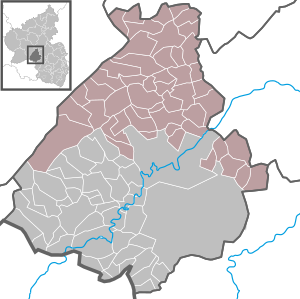
| Location of the Herrstein-Rhaunen community in the Birkenfeld district | ||
  |
||


The municipality Mr. Stone Rhaunen was 1 January 2020 from the voluntary association of Rhineland-Palatinate Verbandsgemeinden Herrnstein and Rhaunen in Birkenfeld . It bears the name of the Herrstein-Rhaunen National Park Association and, in addition to its headquarters in Herrstein, has an administrative office in Rhaunen . The new community community includes 50 local communities .
geography
The area around Herrstein is part of the Hunsrück-Hochwald National Park and the area around Rhaunen is between Idarwald and Soonwald .
Association members communities
| Local parish | Area (km²) | Residents |
|---|---|---|
| Allenbach | 27.54 | 620 |
| Asbach | 3.47 | 143 |
| Mountains | 10.42 | 446 |
| Berschweiler near Kirn | 7.53 | 266 |
| Bollenbach | 3.77 | 131 |
| Breitenthal | 3.68 | 315 |
| Bruchweiler | 8.13 | 492 |
| Bundenbach | 7.70 | 842 |
| Dickesbach | 4.91 | 416 |
| Fischbach | 4.00 | 858 |
| Rumor | 2.29 | 220 |
| Gosenroth | 4.49 | 237 |
| Griebelschied | 4.19 | 177 |
| Hausen | 4.99 | 198 |
| Hellertshausen | 7.46 | 175 |
| Herborn | 2.46 | 502 |
| Mr. Stein | 4.79 | 823 |
| Hettenrodt | 5.32 | 627 |
| Hintertiefenbach | 4.68 | 314 |
| Horbruch | 5.18 | 333 |
| Hottenbach | 11.21 | 575 |
| Kempfeld | 9.66 | 772 |
| Kirschweiler | 4.89 | 1,057 |
| Krummenau | 4.32 | 165 |
| Boring | 5.20 | 238 |
| Mackenrodt | 4.90 | 384 |
| Mittelreidenbach | 5.07 | 736 |
| Mörschied | 10.70 | 789 |
| Niederhosenbach | 7.43 | 281 |
| Niederwörresbach | 9.35 | 864 |
| Oberhosenbach | 4.14 | 134 |
| Upper brain | 5.45 | 319 |
| Oberreidenbach | 10.93 | 609 |
| Oberwörresbach | 1.40 | 116 |
| Rhaunen | 10.75 | 2.154 |
| Showers | 7.12 | 491 |
| Schmidthachenbach | 10.05 | 375 |
| Schwerbach | 2.55 | 48 |
| Sensweiler | 8.43 | 422 |
| Sien | 8.47 | 531 |
| Sienhachenbach | 7.60 | 191 |
| Sonnschied | 3.85 | 96 |
| Stipshausen | 11.11 | 813 |
| Sulzbach | 6.68 | 285 |
| Veitsrodt | 7.94 | 695 |
| Vollmersbach | 2.44 | 453 |
| Pastures | 2.60 | 87 |
| Weitersbach | 7.75 | 94 |
| Wickenrodt | 5.27 | 163 |
| Wirschweiler | 10.26 | 295 |
| Association community as a whole | 334.52 | 22,367 |
(Residents on December 31, 2019)
badges and flags
The Verbandsgemeinde will have a coat of arms and a flag .
politics
Association municipal council
The local council Mr. Stone Rhaunen consists of 36 elected honorary council members, who in the local elections on May 26, 2019 in a personalized proportional representation were elected, and the full-time mayor as chairman.
The distribution of seats in the municipal council:
| choice | SPD | CDU | FDP | GREEN | LUB | FWPH | WGPR | total |
|---|---|---|---|---|---|---|---|---|
| 2019 | 11 | 11 | 4th | 3 | 2 | 3 | 2 | 36 seats |
- LUB = List of Independent Citizens e. V.
- FWPH = Free Voters Pro Hunsrück
- WGPR = voter community PRO Region e. V.
mayor
Uwe Weber (SPD) became the first mayor of the new community of Herrstein-Rhaunen on January 1, 2020. In the direct election on May 26, 2019, he was elected to the new office with 73.0% of the votes.
Web links
Individual evidence
- ↑ a b State Statistical Office of Rhineland-Palatinate - population status 2019, districts, municipalities, association communities ( help on this ).
- ^ The regional returning officer RLP: Association municipal council elections 2019 Herrstein-Rhaunen. Retrieved August 12, 2019 .
- ↑ Nahe-Zeitung: Preliminary final result for VG Herrstein-Rhaunen: Uwe Weber becomes mayor with 73.0 percent. May 26, 2019, accessed December 14, 2019 .
