
Hintertiefenbach
| coat of arms | Germany map | |
|---|---|---|

|
Coordinates: 49 ° 44 ' N , 7 ° 21' E |
|
| Basic data | ||
| State : | Rhineland-Palatinate | |
| County : | Birch field | |
| Association municipality : | Herrstein-Rhaunen | |
| Height : | 338 m above sea level NHN | |
| Area : | 4.68 km 2 | |
| Residents: | 314 (Dec. 31, 2019) | |
| Population density : | 67 inhabitants per km 2 | |
| Postal code : | 55743 | |
| Area code : | 06784 | |
| License plate : | BIR | |
| Community key : | 07 1 34 041 | |
| Association administration address: | Brühlstrasse 16 55756 Herrstein |
|
| Website : | ||
| Local Mayor : | Gerd Conzelmann | |
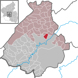
| Location of the local community Hintertiefenbach in the district of Birkenfeld | ||
  |
||

Hintertiefenbach is a municipality in the Birkenfeld district in Rhineland-Palatinate . It belongs to the Herrstein-Rhaunen community .
geography
The village is north of the Nahe in a valley basin. It is traversed by the "Hintertiefenbach" (tributaries: Gilzbach, Bach an der Bismarckeiche, Waldbach, Edemisbach).
The Wassergall settlement also belongs to Hintertiefenbach.
history
- 1338 First documentary mention of the place under the name Inredyfinenbach. The place belonged with the other abbey communities Göttschied, Gerach, Regulshausen, (Höhweiler and Ritzenberg) to the Mettlach monastery .
- On October 14, 1560 the monastery sold the four villages to the rear county of Sponheim. The name of the village changes in the course of its history to Heredifenbach, Niederdiffenbach, Unterdefenbach and Underdiffenbach.
- In 1776 the village belongs to the margraviate of Baden.
- In 1783 serfdom is revoked.
- 1792 affiliation of the village to Mairie Fischbach in the canton of Herrstein.
- In 1817, through the resolutions of the Congress of Vienna, the place was added to the Principality of Birkenfeld in the Grand Duchy of Oldenburg.
- 1824 Introduction of the school system in the 4 abbey communities.
- In 1879, after the mayor's office in Fischbach was dissolved, the village again belonged to the Herrstein district.
- 1880 New school building
- 1908 Construction of water pipes.
- 1913 Hintertiefenbach receives electricity supply
- 1937 According to the Reich Law of January 26, 1937, Hintertiefenbach is transferred to Prussia from April 1, 1937 within the Oldenburg region of Birkenfeld.
- March 18, 1945, the site was occupied by the US Army, which handed over management to France in July of the same year.
- In 1946 Hintertiefenbach became a local community in the then newly formed state of Rhineland-Palatinate, district of Birkenfeld.
politics
Municipal council
The council in Hintertiefenbach consists of eight council members, who in the local elections on May 26, 2019 in a majority vote were elected, and the honorary mayor as chairman.
Local mayor
Gerd Conzelmann became mayor of Hintertiefenbach on July 10, 2019. In the direct election on May 26, 2019, he was elected for five years with 79.53% of the vote.
Its predecessors were:
- 1949–1952 Albert Brust
- 1952–1964 Paul Mayer
- 1964–1965 Otto Bernhard
- 1966–1969 Albert Brust
- 1969–1979 Jakob Franzmann
- 1979–1999 Ewald Brust
- 1999–2019 Alexander Ebels
traffic
- Hintertiefenbach is crossed by Kreisstraße 37. Bundesstraße 41 runs in the southeast .
- In Weierbach there is a train station on the Bingen – Saarbrücken line .
Sons and daughters of the church
- Hugo Mayer (1899–1968), CDU politician and Member of the Bundestag
- Kurt Bohr (* 1947), politician in Saarland, sports official
Powder hole
In earlier times, three copper tunnels were built in the immediate vicinity, but they were abandoned due to insufficient yield. This is where the name of the corridor could be traced back to, as it was usually the name given to deposits of gunpowder used to blast tunnels into the rock.
See also
Web links
- Local community Hintertiefenbach on the website of the Herrstein-Rhaunen community
- Literature about Hintertiefenbach in the Rhineland-Palatinate state bibliography
Individual evidence
- ↑ State Statistical Office of Rhineland-Palatinate - population status 2019, districts, communities, association communities ( help on this ).
- ↑ State Statistical Office Rhineland-Palatinate (ed.): Official directory of the municipalities and parts of the municipality. Status: January 2020. S. 29 (PDF; 1 MB).
- ↑ Archive - State Main Archive Koblenz / Inventory 393 - Government Birkenfeld / Case File 2775 - Hintertiefenbach
- ↑ Archive - State Main Archive Koblenz / Stock 393 - Government Birkenfeld / Case File 4139 - Hintertiefenbach
- ^ The Regional Returning Officer Rhineland-Palatinate: Local elections 2019, city and municipal council elections.
- ↑ Constituent meeting in Hintertiefenbach. In: Our home. Linus Wittich Medien GmbH, edition 31/2019, accessed on August 22, 2020 .
- ^ The State Returning Officer Rhineland-Palatinate: Local elections 2019, individual results. Retrieved August 19, 2020 .
- ↑ Chronicle. Community personalities. Hintertiefenbach parish, accessed on August 22, 2020 .

Adventure | Achtelsbach | Allenbach | Asbach | Baumholder | Mountains | Berglangenbach | Berschweiler at Baumholder | Berschweiler near Kirn | Birkenfeld | Bollenbach | Börfink | Breitenthal | Bruchweiler | Bridges | Buhlenberg | Bundenbach | Dambach | Dickesbach | Dienstweiler | Eckersweiler | Elkweiler | Ellenberg | Ellweiler | Fischbach | Fohren-Linden | Frauenberg | Gerach | Gimbweiler | Gollenberg | Gösenroth | Griebelschied | Hahnweiler | Hattgenstein | Hausen | Heimbach | Hellertshausen | Herborn | Herrstein | Hettenrodt | Hintertiefenbach | Hoppstädten-Weiersbach | Horbruch | Hottenbach | Idar-Oberstein | Kempfeld | Kirschweiler | Kronweiler | Krummenau | Boring | Leisel | Leitzweiler | Mackenrodt | Meckenbach | Mettweiler | Mittelreidenbach | Mörschied | Niederbrombach | Niederhambach | Niederhosenbach | Niederwörresbach | Nohen | Oberbrombach | Oberhambach | Oberhosenbach | Upper brain | Oberreidenbach | Oberwörresbach | Reichenbach | Rhaunen | Rimsberg | Rinzenberg | Rohrbach | Rötsweiler-Nockenthal | Rückweiler | Ruschberg | Showers | Schmidthachenbach | Schmissberg | Schwerbach | Swelling | Sensweiler | Sien | Sienhachenbach | Siesbach | Sonnenberg-Winnenberg | Sonnschied | Stipshausen | Sulzbach | Veitsrodt | Vollmersbach | Pastures | Weitersbach | Wickenrodt | Wilzenberg-Hussweiler | Wirschweiler