
Horbruch
| coat of arms | Germany map | |
|---|---|---|

|
Coordinates: 49 ° 53 ' N , 7 ° 14' E |
|
| Basic data | ||
| State : | Rhineland-Palatinate | |
| County : | Birch field | |
| Association municipality : | Herrstein-Rhaunen | |
| Height : | 455 m above sea level NHN | |
| Area : | 5.18 km 2 | |
| Residents: | 333 (Dec. 31, 2019) | |
| Population density : | 64 inhabitants per km 2 | |
| Postal code : | 55483 | |
| Area code : | 06543 | |
| License plate : | BIR | |
| Community key : | 07 1 34 043 | |
| Association administration address: | Brühlstrasse 16 55756 Herrstein |
|
| Website : | ||
| Local Mayor : | Klaus-Peter Hepp | |
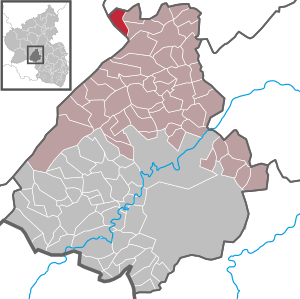
| Location of the local community Horbruch in the Birkenfeld district | ||
  |
||


Horbruch is a municipality in the Birkenfeld district in Rhineland-Palatinate . It belongs to the Herrstein-Rhaunen community .
geography
Horbruch is located in the Hunsrück northwest of the Idarkopf ( 746 m above sea level ). 44.3 percent of the district area is forested. To the west is Hochscheid , in the north Hirschfeld (Hunsrück) and to the east is Krummenau .
The residential areas Bergmühle, Emmerichsmühle, Forsthaus Horbruch, Hockenmühle and Neumühle also belong to Horbruch.
Population development
The development of the population of Horbruch, the values from 1871 to 1987 are based on censuses:
|
|
politics
Municipal council
The local council in Horbruch consists of eight council members, who were elected by a majority vote in the local elections on May 26, 2019 , and the honorary local mayor as chairman.
mayor
Klaus-Peter Hepp became mayor of Horbruch in 1999. In the direct election on May 26, 2019, he was confirmed in his office for another five years with a share of 61.71% of the votes.
coat of arms
|
|
Blazon : "In the obliquely left divided shield in front a golden horn in black, behind red-silver chess." |
| Justification of the coat of arms: The horn was taken from the earlier court seal of Horbruch. The horn may mean a " talking symbol " for the place name. The rear part of the shield refers to the former belonging to the Hinteren Grafschaft Sponheim . |
Economy and Infrastructure
There is a kindergarten and a village community center in Horbruch. In Traben-Trarbach there is a train station on the Pünderich – Traben-Trarbach line . In the north are the federal highway 50 and the Frankfurt-Hahn airport . The so-called Hunsrückquerbahn runs through the district, which can no longer be operated until further notice due to high investment requirements.
See also
Web links
- Local community Horbruch on the website of the Herrstein-Rhaunen community
- Literature about Horbruch in the Rhineland-Palatinate State Bibliography
Individual evidence
- ↑ a b State Statistical Office of Rhineland-Palatinate - population status 2019, districts, municipalities, association communities ( help on this ).
- ↑ State Statistical Office Rhineland-Palatinate (ed.): Official directory of the municipalities and parts of the municipality. Status: January 2020. S. 29 (PDF; 1 MB).
- ↑ State Statistical Office Rhineland-Palatinate: My village, my city. Retrieved February 9, 2020 .
- ^ The Regional Returning Officer Rhineland-Palatinate: Local elections 2019, city and municipal council elections.
- ↑ Long faces in Steitz and Brzoska. Horbruch: Klaus-Peter Hepp. In: Nahe newspaper. Mittelrhein-Verlag GmbH, Koblenz, May 26, 2014, accessed on August 22, 2020 .
- ^ The Regional Returning Officer Rhineland-Palatinate: direct elections 2019. see Herrstein-Rhaunen, Verbandsgemeinde, 21st line of results. Retrieved August 22, 2020 .

Adventure | Achtelsbach | Allenbach | Asbach | Baumholder | Mountains | Berglangenbach | Berschweiler at Baumholder | Berschweiler near Kirn | Birkenfeld | Bollenbach | Börfink | Breitenthal | Bruchweiler | Bridges | Buhlenberg | Bundenbach | Dambach | Dickesbach | Dienstweiler | Eckersweiler | Elkweiler | Ellenberg | Ellweiler | Fischbach | Fohren-Linden | Frauenberg | Gerach | Gimbweiler | Gollenberg | Gösenroth | Griebelschied | Hahnweiler | Hattgenstein | Hausen | Heimbach | Hellertshausen | Herborn | Herrstein | Hettenrodt | Hintertiefenbach | Hoppstädten-Weiersbach | Horbruch | Hottenbach | Idar-Oberstein | Kempfeld | Kirschweiler | Kronweiler | Krummenau | Boring | Leisel | Leitzweiler | Mackenrodt | Meckenbach | Mettweiler | Mittelreidenbach | Mörschied | Niederbrombach | Niederhambach | Niederhosenbach | Niederwörresbach | Nohen | Oberbrombach | Oberhambach | Oberhosenbach | Upper brain | Oberreidenbach | Oberwörresbach | Reichenbach | Rhaunen | Rimsberg | Rinzenberg | Rohrbach | Rötsweiler-Nockenthal | Rückweiler | Ruschberg | Showers | Schmidthachenbach | Schmissberg | Schwerbach | Swelling | Sensweiler | Sien | Sienhachenbach | Siesbach | Sonnenberg-Winnenberg | Sonnschied | Stipshausen | Sulzbach | Veitsrodt | Vollmersbach | Pastures | Weitersbach | Wickenrodt | Wilzenberg-Hussweiler | Wirschweiler