
Kaiserslautern
| coat of arms | Germany map | |
|---|---|---|

|
Coordinates: 49 ° 27 ' N , 7 ° 46' E |
|
| Basic data | ||
| State : | Rhineland-Palatinate | |
| Height : | 251 m above sea level NHN | |
| Area : | 139.74 km 2 | |
| Residents: | 100,030 (Dec. 31, 2019) | |
| Population density : | 716 inhabitants per km 2 | |
| Postcodes : | 67655-67663 | |
| Primaries : | 0631, 06301 | |
| License plate : | KL | |
| Community key : | 07 3 12 000 | |
| LOCODE : | DE KLT | |
| NUTS : | DEB32 | |
| City structure: | Core city (9 areas) and 9 local districts / districts | |
City administration address : |
Willy-Brandt-Platz 1 67657 Kaiserslautern |
|
| Website : | ||
| Lord Mayor : | Klaus Weichel ( SPD ) | |
| Location of the city of Kaiserslautern in Rhineland-Palatinate | ||
 .svg) |
||

.png)
Kaiserslautern ( , Palatinate : Lautre ) is an independent industrial and university city on the northwestern edge of the Palatinate Forest in the south of Rhineland-Palatinate . It is the seat of the district administration of the district Kaiserslautern .
Kaiserslautern was already a royal court in Carolingian times. The settlement's heyday began in the middle of the 12th century, when Frederick I Barbarossa had the castle built around 1100 expanded into a palace . During the Thirty Years War , the city was conquered successively by Spaniards , Swedes and Imperialists. During the Palatinate and Spanish War of Succession , the French occupied the city and destroyed Barbarossa's castle and the castle built next to it by Johann Casimir in the 16th century. In the middle of the 19th century, the city, now part of the Kingdom of Bavaria , became the center of the Palatinate uprising ; At the same time, thanks to the establishment of numerous companies in the textile , metal and mechanical engineering sectors, alongside Ludwigshafen am Rhein, it developed into the most important industrial location in the Palatinate .
On December 31, 2019, the city had 100,030 inhabitants; it is the fifth largest city in Rhineland-Palatinate.
In terms of area, Kaiserslautern is the largest city in Rhineland-Palatinate.
The Kaiserslautern Military Community with around 50,000 military personnel and civilians is the world's largest US military base outside the United States . People belonging to the military community who live in Kaiserslautern are not taken into account in the population.
geography

location
Kaiserslautern is 251 meters above sea level on the north-western edge of the Palatinate Forest in the Kaiserslautern Basin , which in turn is part of the St. Ingbert-Kaiserslauter Senke . The urban area expands in the west into the Landstuhler Bruch , which is bordered in the south by the Sickinger Höhe . The north-west of the urban area is part of the Reichswald and already extends as far as the North Palatinate Uplands. The next larger cities are Ludwigshafen am Rhein , about 50 km to the east, Mainz about 80 km to the northeast, Saarbrücken about 60 km to the west and Karlsruhe about 50 km to the south-east. Kaiserslautern is located on a red sandstone mountain , which was originally covered by limestone sediments. However, these sediments were later washed out and deposited in the Westrich .
The following cities and municipalities border the city of Kaiserslautern, they are named starting in clockwise direction in the north and are all - except for the municipality of Elmstein , which belongs to the Bad Dürkheim district - in the Kaiserslautern district :
Otterbach , Otterberg , Mehlingen , Enkenbach-Alsenborn , Fischbach , Hochspeyer , Waldleiningen , Elmstein, Trippstadt , Stelzenberg , Schopp , Krickenbach , Queidersbach , Bann , Kindsbach , Landstuhl , Ramstein-Miesenbach , Rodenbach , Weilerbach and Katzweiler .
Surveys

The city is framed in the south and east by wooded heights such as the 285 m high Betzenberg or the approximately 280 m high Lämmchesberg , both of which are located immediately south of the city center and the Little Woodpecker and the Great Steinberg . Further south extends the 427.9 m Humberg as well as the Große , the Middle and the Kleine Krebser and to the southeast the Dammberg , the 450 m high Harte Kopf as well as the Brotpfadkopf and the Felsenbrunnenkopf .
In the east on the boundary to Hochspeyer is the 393.7 m high Heiligenberg , northwest of this the Totenkopf and the Beilsteiner Kopf and in the northeast of the urban area the 394 m high Queitersberg . The 459.8 m high owl head rises within Mölschbach and the Schlossberg at the level of the Hohenecken district .
In the north of the urban area is the Rotenberg, which is already part of the North Palatinate Bergland. The 290 m high Kaiserberg is located in the middle of the northwest of the city center . The 275 m high Stöffelsberg also extends in the middle of the settlement area of the Erfenbach district .
Waters

The city is traversed by the Lauter, which, however, is underground in the city center. Within the urban area, the Hammerbach flows into this from the left , which previously flows through the Vogelwoog and the Hammerwoog . Other tributaries of the Lauter within the urban area are the Eselsbach , Frauenwiesbach , Kohbach and Eimerbach , with the latter forming the boundary with Katzweiler. The catchment area of the Lauter also includes the sources Dammbrunnen and Hungerbrunnen in the Palatinate Forest .
The Palatinate main watershed runs through the south of the urban area . The Aschbach - called Rambach in this area - rises within the forest area of the Mölschbach district, flows through it and takes on the Eulenmühlbach from the left . Further to the west, it forms for the most part almost the southern city limit and flows through the hunting lodge pond there . On the south-western outskirts there is also the Gelterswoog , which draws its water from several tributaries of the Aschbach, including the Hoheneckermühlbach . The catchment area of the Aschbach also includes the Felsenbrunnen located on the border with Waldleiningen and the Moosbrunnen northwest of Mölschbach .
climate
Kaiserslautern lies within the temperate climate zone with precipitation in all seasons. Compared to other regions in Germany , Kaiserslautern has a very warm and very sunny climate. Due to the location in the lee of the Hunsrück and Eifel , precipitation is usually withheld in north-west weather conditions.
The annual precipitation is 782 mm. Precipitation is in the lower third of the values recorded in Germany ; lower values are recorded at 31 percent of the measuring stations of the German Weather Service . The driest month is April, with the most rainfall in December, about 1.5 times more rainfall than April. Precipitation varies only minimally and is extremely evenly distributed over the year. Lower seasonal fluctuations are recorded at just two percent of the measuring stations .
|
Monthly averages for Kaiserslautern
Source: DWD; Wetterkontor.de; Urlaubplanen.org
|
||||||||||||||||||||||||||||||||||||||||||||||||||||||||||||||||||||||||||||||||||||||||||||||||||||||||||||||||||||||||||||||||||||||||||||||||||||||||||||||||||||||||||||||||||||
City structure
The area of the Kaiserslautern core city is traditionally divided into fifths , which are characterized by the colors blue (south-west), white (west), yellow (north-west), red (north-east) and green (south-east). This division is still reflected, for example, in the traditional enamel signs with the house number, which by color also indicate that they belong to the fifth ; The color of the old street signs attached to house walls or names such as Red Pharmacy and Green Pharmacy also refer to the fifth . The structure was introduced by the French occupation administration at the turn of the 19th century. The fifths no longer have any administrative significance.
With the incorporation of the surrounding localities on June 7, 1969, the new districts received a local advisory board and a local councilor ; the local councils were to be heard on important matters affecting the local district. After the state of Rhineland-Palatinate had opened up the possibility of setting up local councils in cities in its municipal law, the entire city was divided into 18 local districts in order to increase proximity to the citizens. The final decision on a measure was then left to the city council of the entire city of Kaiserslautern. The local councils were only able to decide on individual measures under their own authority.


| Official Num. | Core city | Residents |
|---|---|---|
| 01 | Downtown east | 11,444 |
| 02 | Downtown southwest | 8,883 |
| 03 | Downtown West / Kotten | 10,935 |
| 04 | Downtown north / Kaiserberg | 9,017 |
| 05 | Dimple valleys / Volkspark | 9,889 |
| 06 | Betzenberg | 4,758 |
| 07 | Lämmchesberg / Uniwohnstadt | 11,048 |
| 08 | Bännjerrück / Karl-Pfaff-Siedlung | 5,360 |
| 09 | Kaiserslautern-West | 8,517 |
| 10 | Erzhütten-Wiesenthalerhof | 2,653 |
| Core city as a whole | 79,851 | |
| Official Num. | Districts | Residents |
| 11 | Einsiedlerhof | 1,322 |
| 12 | Morlautern | 3,145 |
| 13 | Erlenbach | 2.223 |
| 14th | Mölschbach | 1,179 |
| 15th | Dansenberg | 2,644 |
| 16 | Hohenecken | 3,654 |
| 17th | Siegelbach | 2,690 |
| 18th | Erfenbach | 2,875 |
| Total districts | 22,385 | |
| City overall | 102.236 | |
(Population: June 30, 2018)
At the end of 2002 the main statutes of the city were changed and the districts for the core city were dissolved again. Since then, local districts have only existed for Einsiedlerhof, Morlautern, Erlenbach, Mölschbach, Dansenberg, Hohenecken, Siegelbach and Erfenbach. In 2008 the Erzhütten / Wiesenthalerhof district was reintroduced.
history
Early history
The area around Kaiserslautern has been populated since the Neolithic in the form of the ceramic band culture - corresponding to the sixth and fifth millennia BC - and Roman settlement can also be proven.
Since the Hallstatt period - the eighth century BC - the Kaiserslautern area was probably inhabited throughout. Several Celtic burial mounds in the urban area date from this time, for example near the lime kiln, in the ditch where excavations took place in the 1930s and north of today's federal motorway 6, as evidenced by excavations carried out in 2003 and 2004.
Remains have also been preserved from Roman times , for example under the collegiate church and the associated monastery; however, they do not allow the character of a settlement to be clarified. The location on a lowland allows for a villa rustica as well as a street station.
Roman road embankments have been found south of Kaiserslautern between the grounds of the Technical University and the northeast slope of the Dansenberg, and remnants of the " via regalis " have been preserved, the military road from Metz to Mainz, which runs roughly parallel to today's Bundesstraße 40 and has been closed since prehistoric times is occupied. There is no evidence of the period after the Roman withdrawal at the beginning of the fifth century.
In the Carolingian era in the seventh century, the increase in the population led to the expansion of the settlement area from the Rhine plain into the forest areas and to develop them with new traffic routes, economic and administrative centers. These newly developed areas included the Kaiserslautern area.
830 which was Villa Luthra of - Old High German luttar , clear, bright and aha , water - in Lorsch Empire reclaimed first mentioned. After 1152, Barbarossa had a palace built here, which is why Kaiserslautern is still considered a Barbarossa city today.
City foundation and name
In 1276 Rudolf von Habsburg granted Lautern city rights .
The status of a Free Imperial City and the rights associated with it cannot be maintained for long. As early as 1313 or 1314, the city was pledged to Count Georg von Veldenz and Gottfried von Leiningen , and in 1322 by the later Emperor Ludwig the Bavarian to King John of Bohemia . The name " Keyserslutern " appears for the first time in this deed of attachment . After further pledging, the city was ceded to Elector Ruprecht I of the Palatinate as an imperial pledge in 1357 and then passed to the Electoral Palatinate. Since 1375, the city, now called Kaiserslautern , was pledged to the Electoral Palatinate and thus the seat of an Electoral Palatinate Office or Upper Office.
Historically, Kaiserslautern was also called by its Latin name: Caesarea lutra . Lutra because of the river that flowed through Kaiserslautern. Today the Lauter runs underground through the city. In 1322 the name Kayserslûtern was first attested in a document . The addition of the word Kaiser probably refers to the work of Emperor Frederick I Barbarossa, who had the imperial palace built here from 1152 and stayed there five times up to 1186 to prepare for crusades.
History until 1900

After 1571 Johann Casimir had a castle built next to the Barbarossaburg as ruler of the Palatinate-Lautern . During the Thirty Years War the city was fought over and occupied several times. In 1688 the city was reoccupied by the French in the War of the Palatinate Succession and then in the War of Spanish Succession in 1703, the palace and castle were then blown up. In 1768 the "Physikalisch-Ökonomische Gesellschaft" (Physical-Economic Society) was founded, from which the Hohe Kameral School emerged in 1774 and which was relocated to Heidelberg in 1784 . After the Napoleonic Wars , Kaiserslautern came under French rule in 1801 and became the seat of a sub-prefecture.
After the Wars of Liberation, the Palatinate, and with it Kaiserslautern, became Bavarian in 1816 . During the revolution of 1849 a provisional government resided in the Fruchthalle , which proclaimed the independence of the Palatinate from Bavaria. After 1850, Kaiserslautern developed into an industrial city. With the establishment of facilities such as the worsted spinning mill and the Pfaff sewing machine factory , the city developed into the most important industrial location in the Palatinate.
20th century
After the First World War , the city was under French administration (until 1930), while separatist riots rose in 1923 and 1924.
On March 1, 1920, the city was spun off from the Kaiserslautern District Office and thus became a district.
During the Second World War there were repeated massive air raids from 1940 onwards , and the city was evacuated several times . The city was largely destroyed in several major air raids in 1944/45. On March 20, 1945, the city was captured by the Americans (see Operation Undertone ), which ended the war for Kaiserslautern.
The city became part of the French occupation zone after World War II . The establishment of the state of Rhineland-Palatinate was ordered on August 30, 1946 as the last state in the western occupation zones by ordinance number 57 of the French military government under General Marie-Pierre Kœnig . It was initially referred to as the "Rhineland-Palatinate Land" or "Land Rheinpfalz"; the name Rhineland-Palatinate was only established with the constitution of May 18, 1947. The post-war period was characterized, among other things, by a “traffic-friendly” reconstruction of the city (see also car- friendly city ) and the influx of thousands of displaced persons. At the same time, the Kaiserslautern area became the largest US garrison outside the USA in the form of the Kaiserslautern Military Community
On November 14, 1956, a US Air Force F-86 fighter jet crashed into the district office in the area of Burgstrasse and Maxstrasse. In addition to the pilot, two other people died. Numerous people were injured.
With the incorporation of the previously independent communities of Dansenberg, Erfenbach, Erlenbach, Hohenecken, Mölschbach, Morlautern and Siegelbach on June 7, 1969, Kaiserslautern became a major city . The University of Kaiserslautern was founded in 1970 .
The industry, which flourished again until about the first oil crisis (1973), which was shown by the establishment of Opel in 1966 , was hampered in some places by the military use of large areas. In the 1970s, many industrial companies got into a crisis. In 1981 the worsted spinning mill went bankrupt; Pfaff and Opel fired employees. The downsizing of the American garrison and the withdrawal of the French garrison cost additional jobs.
In the meantime, Kaiserslautern is developing into a science and IT city , supported by the state's conversion projects . Successful projects in this context are the establishment of the PRE Park , two Fraunhofer Institutes ( Fraunhofer Institute for Industrial Mathematics and Fraunhofer Institute for Experimental Software Engineering ) and the Max Planck Institute for Software Systems near the Technical University as well of the German Research Center for Artificial Intelligence (DFKI). The city of Kaiserslautern is also a “corporate sponsoring member” of the Max Planck Society . At the beginning of the 2010s, construction began on the inner-city shopping center K in Lautern . This was opened as scheduled on March 25, 2015.
In 2015, the Kalkofen social hotspot achieved national recognition through a documentary lasting several hours on the TV station VOX .
Kaiserslautern legends
There are many legends about the history of Kaiserslautern. Some of these are of great importance to the city. The fish in the Kaiserslautern coat of arms can be traced back to the legend of the pike in the Kaiserwoog . Another legend, the so-called legend of Lutrina , tells of the pious woman Lutrina, who came from Trier , who fled into the wilderness at the time of the great persecution of Christians and built an apartment there, which she called Lutrea. This is said to have given Lautern its name. Lutrina is still the name of a street in Kaiserslautern, at the end of which is the Lutrina Clinic. Another legend is the cock's fold .
population
Population development

At the end of 2014, Kaiserslautern had 97,382 inhabitants and is therefore, along with Trier , Mainz , Ludwigshafen am Rhein and Koblenz, a regional center of the state of Rhineland-Palatinate . In addition, there are almost 48,000 Americans; These are either current or soldiers, civil employees and their family members who are on duty in Kaiserslautern and at the Ramstein Air Force Base and who live in the city and the district . The core city, without incorporated villages, has about 85,000 inhabitants.
The population was always between 1000 and 3000 from the middle of the 16th century to around 1800. In 1815 the city had 3757 inhabitants. Between 1802 and 1834 the population doubled to around 7,000. With the onset of industrialization in the mid-19th century, the population grew rapidly ; In 1900 there were already 48,000 people living in the city and in 1937 70,260. At the beginning of the Second World War there were around 70,000 inhabitants, after the end of the war it was still around 56,000.
In 1957 the population had already increased to 86,000 and continued to rise in the following decade as a result of immigration. As a result of the incorporation of several surrounding places, the city exceeded the limit of 100,000 inhabitants in 1969; In 1977 100,100 people lived in Kaiserslautern and in 1997 101,549. In 2000, the city's population fell back below 100,000. A second residence tax of ten percent of the basic rent has been in effect since May 1, 2009 ; the city wanted to bring about more registrations of primary residences in order to raise the population back to over 100,000. On December 31, 2017, the city had 100,747 inhabitants, according to the city administration. The State Statistical Office reported 99,684 inhabitants for the same reference date. Depending on the source, Kaiserslautern would be a big city or not. As of December 31, 2019, the State Statistical Office reported 100,030 inhabitants, making Kaiserslautern a big city again.
religion
Denomination statistics
As of December 31, 2019, 32.3 percent of the 101,063 inhabitants are Protestant, 25.2 percent Catholic, and 42.4 percent belong to other or no religious communities. Two years earlier - 2017 - of the 102,237 inhabitants, 35,320 - corresponding to 35.3 percent - were Protestant and 27,103 - corresponding to 27.1 percent - were Catholic.
Christianity

At Catholic churches there is the Maria Schutz church in the city center , the branch church of St. Blasius in the Mölschbach district and the Rochuskirche and Rochuskapelle in Hohenecken .
The Protestant churches include the Christ Church , the Small Church and one in Siegelbach .
There is also a so-called willow church on the grounds of the garden show . In the Stockborn settlement belonging to the Erfenbach district, many residents are of the Mennonite faith.
Judaism
Kaiserslautern was the seat of a district rabbinate . From March 1933, the Nazi era also had an impact in Kaiserslautern. At that time the city had 648 Jewish residents, in 1932 there were still 765. Because of the harassment and economic boycott measures that began in 1933, many Jews left Kaiserslautern.

From 1894 to 1896 the synagogue in what was then Frühlingsstraße - currently known as Luisenstraße - was built in the Moorish-Byzantine style according to plans by the architect Ludwig Levy . It shaped the cityscape of Kaiserslautern at that time and was considered a sight. In 1938 the Jewish community was forced to leave the synagogue to the city, which had the building blown up. In August of the same year, its remains were demolished because the National Socialists did not fit it into the cityscape.
During the November pogroms in 1938 , numerous shops and apartments belonging to Jewish citizens were ransacked and looted in front of the police, Jewish citizens were mistreated, and their property was confiscated ( "Aryanized" ).
Most of the Germans of Jewish faith still living in Kaiserslautern were deported to Camp de Gurs in southern France on October 22, 1940 in the Wagner-Bürckel campaign . Only a few managed to escape from there; many died of hunger and disease. In August 1942, transports of the survivors to the gas chambers of Auschwitz and Lublin-Majdanek were arranged. Of the 90 Jews who still lived in Kaiserslautern in 1939, at least 78 were murdered after their deportation. In the east of the city is the Jewish cemetery .
In 1980 the site of the former synagogue was officially renamed Synagogenplatz . In 2001 it was virtually reconstructed in a project by the Technical University of Darmstadt . In 2002 a memorial was erected on the foundation of the blown synagogue in memory of the Jewish victims of National Socialism in Kaiserslautern.
Cityscape


Due to its strategically important location on one of the few passes between the Rhine and Moselle ( via regalis ), the city has been repeatedly destroyed in the course of its history. The rapid industrialization of the city in the 19th century, the bombing during the Second World War, the traffic-friendly reconstruction after the war and the redevelopment of the old town (area redevelopment) in the late 1960s and early 1970s led to significant losses of historical building fabric.
Nevertheless, a number of remarkable individual buildings, ensembles and historical floor plans have been preserved, even if they no longer fit into a historical urban ensemble.
Middle Ages and early modern times
Notable buildings from the Middle Ages and early modern times are the Protestant collegiate church and the Catholic Martinskirche as well as the remains of the Barbarossaburg with Casimirsaal . Some remains of the city wall and a side wing of a Gothic patrician house, hidden in the backyard of Marktstrasse 8, have been preserved.
Baroque buildings are located around Martinsplatz , in Klosterstrasse (diocese house), on Rittersberg (Gasthaus Ritters) and in Schillerstrasse (Gasthaus Zum Spinnrädl ). Classicist buildings can be found in Friedenstrasse (former cemetery chapel), Marktstrasse ( Adler pharmacy ), Scheidstrasse / corner of Matzengasse and Steinstrasse 49 ( Villa Karcher ).
The time up to the First World War
The majority of the preserved cultural monuments date from the second half of the 19th century to the end of the German Empire. Typical of the Wilhelminian style is the block development with eaves-facing houses. Noteworthy are the fruit hall, which is now used as a concert hall , the commercial museum (now the Museum Pfalzgalerie Kaiserslautern ), the Marienkirche and the Apostlekirche , as well as the monument zone around the city park and the villa district in Petroloring / Villenstrasse. Representative administrative buildings of the Wilhelminian era are the former main post office in Karl-Marx-Straße (today Deutsche Telekom), the former district command (today police headquarters ) in Logenstraße, the royal main customs office (today tax office) in Eisenbahnstraße, the administrative headquarters of the Palatinate Railways in the Eisenbahnstrasse 73 (now privately used) and the neo-baroque barracks of the 23rd Royal Bavarian Infantry Regiment in the east of the city.
The buildings of the former worsted spinning mill are listed as an industrial monument. The extensive area is now part of the garden show; The Kammgarn cultural center is located in the former boiler house , while parts of the administrative buildings are used by the university of applied sciences.
Art Nouveau monuments are rare in Kaiserslautern. Mention should be made of the former Hotel Brenner across from the train station, the Goetheschule, the residential building at Schumannstrasse 10 and the commercial building at Steinstrasse 15.Notable are two rare examples of cinemas built at a very early stage ( Union from 1911, Kerststrasse; Central from 1913, Osterstrasse) that were still used today as a cinema.
The expansion plans by Eugen Bindewald from 1887 are interesting in terms of urban planning. These go back to: the ring roads in the east of the city area (Barbarossaring, Hilgardring, Petrol ring), the area around today's Kolpingplatz - a roundabout with radial roads - and the city park and in the west of the city the Marienplatz with the Marienkirche. This forms the center of the star-shaped streets converging on it. In 1912 the forest cemetery was laid out according to plans by Hermann Hussong .
Interwar period
Hermann Hussong was one of the personalities who have shaped the cityscape to this day. He created the new version of the Bindewald city expansion plan (1913) and the drafts for the development of the Pfaffenberg and Lämmchesberg.
Starting in 1919, Hussong built the castle-like residential complex on Fischerstrasse , which was paid for as reparations by the German Reich and was originally intended as an officer housing for the French occupation army. After the French renounced the facility, it fell to the non-profit construction company (Bau AG) founded in 1921. On behalf of Bau AG, Hussong built numerous residential buildings to combat the housing shortage. The expressionist colorful block in Königstrasse / Marienplatz, the so-called rotunda (Königstrasse) over a D-shaped, the green block (Altenwoogstrasse / Mannheimer Strasse) over an A-shaped floor plan and the Pfaffsiedlung are of monumental rank. The exhibition hall on the grounds of today's Volkspark also comes from Hussong; The complex was destroyed by bombs in 1945, only the monumental group of figures of the horse tamer has survived.
The idea of the garden city was implemented in Kaiserslautern in the Bahnheim , a settlement in the vicinity of the Reichsbahn repair shop . In 1928, the first steel-framed building was erected on Schillerplatz (the Fleischbein-Haus with the Schillerplatz pharmacy on the ground floor), and the main post office at the train station according to plans by Heinrich Müller was created in 1930, an outstanding example of the Bavarian Post Building School , the most important form of New Building in Bavaria. An interesting interpretation of Gothic style elements in an expressionist spirit is shown by the Catholic Minorite Church of Maria Schutz ( Gelöbniskirche ) from 1928/29 on Messeplatz in the east of the city.
The architecture of the time of National Socialism included large estates in the east and west of the city, and various barracks were built. Structures of monumental rank are extensions to the worsted spinning mill and the motorway bridge over the Waschmühltal. Because of the elevation to the Gau capital in 1939, parade and parade grounds were planned; in anticipation of this, the synagogue was demolished in the summer of 1938. The redesign came to a standstill during the war, when Saarbrücken became the new capital of the Saar Palatinate district .
post war period
Nearly two thirds of the city center of Kaiserslautern was destroyed by bombing attacks towards the end of the war. The reconstruction of the city after 1945 followed the traffic regulations of the American occupation army. Much of the existing building fabric was demolished in order to create breakthroughs and widen the streets. When the buildings were rebuilt, they were mostly restored in simplified forms. The new buildings are a result of the sober reconstruction time and the limited financial resources; they seem banal today. Structurally significant buildings from this period are the Evangelical Christ Church (1957/58) and the Evangelical Paulus Church (1958–60), the vocational school on Martin-Luther-Straße (1954–56), the former French officers' mess on Altenhof (1955/56 ), the office building of the Bayerische Hypotheken- und Wechselbank in Fackelstrasse (1956/57), the district administration (1959–60) and the 84 m high town hall (1963–1968), at the time the highest town hall in the Federal Republic.
In order to create accommodation for the American soldiers and civilians, a residential area with multi-family houses was created with the Vogelweh in the west of the city. The residential area Bännjerrück was built in the neighborhood in the 1960s . Furthermore, the Betzenberg in the south and the Fischerrück in the northwest of the city were built with high-rise housing estates. When the university was founded, the university residential area was designated as a mixture of multi-family and single-family houses.
Americans in and around Kaiserslautern
In addition to the official figures from the registration offices, there are almost 48,000 Americans ( soldiers , former soldiers, American civil servants and their family members) living in the city and district of Kaiserslautern , who are organized in the Kaiserslautern Military Community (KMC ). The strong presence of the Americans (the space Kaiserslautern is the largest American settlement outside the US) is related to the air base Ramstein Air Base in Ramstein-Miesenbach , about 10 km west of Kaiserslautern, as well as other facilities of US Army and US Air Force in space Kaiserslautern together.
New residential areas were created especially for the American soldiers, such as Vogelweh in the west of the city, in which the street names are American and have names such as Third Avenue or Florida Loop .
Active military bases of the Americans in Kaiserslautern (as of 2018) are the 21st Sustainment Command (Exp) , the Community Facility , the Daenner Kaserne (with General Support Center - Europe , Movement Control Team and Support Center ), the Einsiedlerhof Training Anx 49 ° 26 ′ 24 ″ N , 7 ° 39 ′ 54 ″ E , the flight simulation Einsiedlerhof Air Station , Hill 365 Radio Relay Fac , Army Depot , Equip Spt Center , Family Housing Anx No 3 , Kapaun Administration Anx , the Kleber Kaserne (with transportation and Kaiserslautern Legal Center ), the Panzer Kaserne (GE642) , the Pulaski Barracks (with Base Support Battalion ), the Rhine Ordnance Barracks and the Vogelweh Family Housing Annex .
The Americans are an important economic factor for the city and the district of Kaiserslautern, and the local German economy and administration have adjusted to the Americans as customers, consumers and tenants. Menus in restaurants are very often bilingual, the US dollar is often accepted as a means of payment alongside the euro and bills in restaurants are e.g. Sometimes issued in both currencies. The city administration has also adapted to the situation and is sending traffic fines to American traffic offenders in English with a demand for payment . However, the city does not accept US dollars. In shops, the employees are often bilingual. The name K-Town ('kā' tau̇n) for Kaiserslautern has established itself among American soldiers and their relatives . Some US Army street signs are labeled with it. The name also appears in songs by the songwriters Reinhard Mey ( All soldiers want to go home , album: colors , 1990) and Franz Josef Degenhardt .
Other cultural monuments
In the middle of the Palatinate Forest in the southern urban area is the Humbergturm , which functions as a lookout tower.
The two most famous castles in the urban area are the Hohenecken castles , also located in the Palatinate Forest , which overlooks the southwestern district of the same name, Hohenecken, and Beilstein Castle , which lies to the east of the city and is hidden in the forest .
In the city center there is the Kammgarn cultural center, which is housed in the buildings of the former worsted spinning mill at the current garden show grounds, and the Kaiserbrunnen at Mainzer Tor , which was created by Gernot Rumpf in 1987 .
The Museum Pfalzgalerie Kaiserslautern was originally intended as a commercial museum and today houses works by Palatinate artists. The focus of the collection is on graphics, paintings and sculptures from the 19th and 20th centuries, especially German impressionism and expressionism. There is also a handicraft collection from the 16th to 19th centuries.
Nature, leisure and parks

There are numerous natural monuments in the urban area . The south of Kaiserslautern in particular is located in the Palatinate Forest Nature Park , which is part of the cross-border Palatinate Forest-Northern Vosges biosphere reserve .
In the middle of the Palatinate Forest are the wildlife park on the Betzenberg and the Fritz Walter Stadium on the Betzenberg , which is used as a venue for home games for 1. FC Kaiserslautern .
In the city center is the garden show , which emerged from the first state horticultural show in Rhineland-Palatinate and houses the largest dinosaur exhibition in Europe.
In the north of the city in the Siegelbach district are the Kaiserslautern Zoo and a few kilometers east of the Waschmühle outdoor pool with the second largest pool in Europe after the Brentano pool in Frankfurt .
The Japanese Garden in Kaiserslautern is a special attraction . It is one of the largest Japanese gardens in Europe.
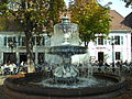
Fountain
Around 50 fountains are open to the public in the city. The best known are shown in the picture gallery below.

Kaiserbrunnen at the Mainzer Tor
Legend of the Kaiserbrunnen
Schwanenbrunnen on Martinsplatz

Spittelmüller fountain on Stiftsplatz
Fountain at Schillerplatz

Fountain at the collegiate church

Giant fountain in the pedestrian zone


politics
City leaders


For centuries, the head of the city of Kaiserslautern was the mayor as the city's highest judge and administrative officer, who was appointed by the elector or the count palatine. The city council and the citizenship elected a councilor and a community mayor as their respective representatives .
In 1906 Hans Küfner became the first legally qualified and full-time mayor. As head of the city, he has held the title of mayor since 1913 . Since 1999 the mayor is no longer elected by the city council, but directly by the population.
|
|
Mayor election
The Mayor election of March 11, 2007 was decided in the first ballot. Klaus Weichel took up his post on September 1, 2007. On December 7, 2014, he was confirmed in office again in the first ballot.
City council
The city council of Kaiserslautern consists of 56 honorary council members, who were elected in a personalized proportional representation in the local elections on May 26, 2019 , and the full-time mayor as chairman.
Because of the special features of the Rhineland-Palatinate electoral system in local elections (personalized proportional representation), the percentages given are shown as weighted results that only represent the voting behavior in arithmetic.
The parties and voter groups achieved the following results:
| Parties and groups of voters | % 2019 |
Seats 2019 |
% 2014 |
Seats 2014 |
|---|---|---|---|---|
| SPD | 25.9 | 15th | 35.4 | 19th |
| CDU | 22.3 | 13 | 29.4 | 15th |
| GREEN | 19.4 | 11 | 11.6 | 6th |
| AfD | 10.7 | 6th | - | - |
| FWG | 7.0 | 4th | 6.4 | 3 |
| FDP | 6.2 | 3 | 6.6 | 3 |
| THE LEFT | 5.5 | 3 | 7.4 | 4th |
| The party | 2.2 | 1 | - | - |
| FBU | 0.7 | 0 | 1.1 | 1 |
| NPD | - | - | 2.1 | 1 |
| total | 100.0 | 56 | 100.0 | 52 |
| Voter turnout in% | 50.8 | 41.7 | ||
Due to the increased population, the number of seats in the city council was increased from 52 to 56.
City coat of arms
|
|
Blazon : "In red a silver pole, topped with a vertical blue fish."
The city colors are red and white. |
| Justification of the coat of arms: The coat of arms of the city of Kaiserslautern shows a silver pole in red, topped with a soaring blue fish, which optionally represents a pike or carp. The stake has been in use since 1266 and represents the Lauter brook. The coat of arms was originally that of the Lauter Reichsschultheißen of Lautern (also written de lutra in documents ), which was probably built in the 13th century after the construction of Hohenecken Castle (today in the same name District of Kaiserslautern) renamed in von Hohenecken (also written de honecken in documents ). From 1373 the fish is documented as a coat of arms figure. The shape of both symbols and the colors of the coat of arms changed several times in the course of history. But the city colors red and white can be traced back to 1545. In its current form, the coat of arms was approved by King Ludwig I of Bavaria on August 3, 1842. In earlier centuries the seal also contained other symbols, for example a battlement wall with buildings interpreted as church towers. |
The coat of arms is often mentioned in connection with the local legend of the pike in the Kaiserwoog .
Finances
On December 31, 2016, Kaiserslautern had the second highest per capita debt of all cities and municipalities in Rhineland-Palatinate at € 11,384. Of the 103 independent cities in Germany, Kaiserslautern has the third highest per capita debt.
Town twinning

Kaiserslautern maintains a large number of city partnerships and friendships. The first partnership was established in 1960.
|
City partnerships:
City friendships: |
Economy and Infrastructure
Economic trends
In 2016, Kaiserslautern achieved a gross domestic product (GDP) of € 4.702 billion within the city limits, making it 66th in the ranking of German cities by economic output . In the same year, GDP per capita was € 47,540 (Rhineland-Palatinate: € 34,118, Germany € 38,180). The GDP per labor force is 66,317. In 2016, the city's GDP grew nominally by 5%, compared to 1.7% in the previous year. In 2017, around 70,900 people were employed in the city. The unemployment rate in December 2018 was 10.8%, twice as high as the average for Rhineland-Palatinate of 4.1% (in the neighboring district of Kaiserslautern it was 3.5%).
In the Future Atlas 2016 , the independent city of Kaiserslautern was ranked 247 out of 402 districts, municipal associations and independent cities in Germany and is therefore one of the regions with a “balanced risk-opportunity mix” for the future.
Companies

Kaiserslautern is still an important industrial city with over 11,000 jobs in industry. The most important employer in the region is the US military community of Kaiserslautern with around 28,000 jobs, of which 6,700 are German civilians.
With the Technical University as a power center, Kaiserslautern is increasingly developing into a science location with a focus on information technology (IT for short), as numerous company foundations and settlements in recent years show. With the name Silicon Woods , Kaiserslautern tries to follow the famous Silicon Valley in California, which is considered the birthplace of important IT companies. Kaiserslautern is located on the northern edge of the Palatinate Forest , hence Silicon "Woods" ( Silicon: English silicon , wood: forest ).
The nationally well-known industrial companies based in Kaiserslautern include the Pfaff sewing machine factory , Eisenwerke Kaiserslautern (today under the name General Dynamics European Land Systems-Germany GmbH), which produces, among other things, military floating vehicles and pontoon bridges, Gebr. Pfeiffer SE (machines for Cement and building materials industry) as well as the ACO Group (until 1997 Guss- und Armaturenwerk Kaiserslautern ), which manufactures industrial and construction castings, such as manhole covers. All of these companies were founded in the second half of the 19th century. The former railway repair plant is now part of the Swedish Euromaint Group.
From the formerly flourishing textile industry, only the Spinnerei Lampertsmühle AG (manufacture of fancy and special yarns ) is preserved, other companies such as the worsted yarn spinning company Kaiserslautern GmbH have gone bankrupt. The most important industrial relocation of recent times is the engine and component factory of Adam Opel AG , on whose premises the GKN joint shaft factory Kaiserslautern GmbH and the logistics company Stute Verkehrs GmbH are located; The automotive industry also includes Corning GmbH (production of ceramic catalyst carriers) and Euromaster GmbH (tire service company operating across Europe, which had its headquarters in Kaiserslautern until 2016). In Kaiserslautern there is also a development center of Johnson Controls (formerly Keiper Recaro Group ) for automobile and aircraft seats .
Other large industrial employers are Freudenberg (nonwovens), CP Schmidt GmbH & Co. KG (cardboard packaging), Wessamat Eismaschinenfabrik GmbH and Wipotec GmbH (weighing systems for industrial applications). The distribution and logistics center for Europe for Fruit of the Loom is also located in Kaiserslautern . The food industry includes the large-scale bakery Barbarossa Bäckerei GmbH , Fleischwerke Beck GmbH and a dairy factory belonging to Hochwald Nahrungsmittel-Werke .
Fuchs Lubritech GmbH , which is part of the Fuchs Petrolub Group and the world's largest independent lubricant manufacturer, has also relocated its headquarters from neighboring Weilerbach to Kaiserslautern after expanding the plant in the northern industrial area . The security company WR-Security & Bewachungs GmbH is one of the largest employers with over 800 employees . The oldest company in the security industry in the city is the Wach- und lock company founded in 1954 .
In 2017, Kaiserslautern took part in the “Digital City” competition organized by the Bitkom digital association in cooperation with the German Association of Towns and Municipalities (DStGB). However, the city of Darmstadt received the award as a “digital city”. Following the competition, a municipal subsidiary, KL.digital GmbH, was founded in Kaiserslautern. It is intended to advance digitization projects in Kaiserslautern.
media
The city has a studio of the private broadcaster RPR1 and the Südwestrundfunk (SWR) and is the seat of the private broadcaster Antenne Kaiserslautern and its umbrella organization The Radio Group . Some citizens of the city put together a television program in the Open Channel Kaiserslautern (OK Kaiserslautern).
As a daily newspaper, the Palatinate People's Newspaper appears as a regional or local edition of the Rheinpfalz based in Ludwigshafen , and the weekly newspaper Kaiserslautern as a free weekly newspaper . There are also free, monthly program and scene magazines (e.g. pavilion , line 1 ).
The infrastructure for the distribution of the media is relatively good: In addition to two providers of public WLAN (to supply private households), there is a Wimax test network. Since the 2006 World Cup , DVB-T reception has been possible for public broadcasters from the Dansenberg and Rotenberg locations (towards Gersweilerhof).
Broadcast facilities
A medium-wave transmitter from the AFN is located near Kaiserslautern near Sambach , which uses a 136-meter-high self-radiating transmitter mast that is isolated from the ground as a transmitting antenna . Since 1951 there has been a 120 meter high SWR transmitter mast on the front Rotenberg, north of the federal autobahn 6 . This Rotenberg transmitter is also isolated from earth, as it was used as a self-radiating transmission mast for a medium wave transmitter until 1975. Since 2004 it has been used again as a medium wave transmitter, but in DRM mode.
On the Dansenberg south of Kaiserslautern, the T-Systems subsidiary Media & Broadcast GmbH (M&B) operates the 133-meter-high Kaiserslautern telecommunications tower made of reinforced concrete (type tower), which was built from September 1985 to May 1987 and went into operation on August 30, 1988 . On May 27, 2006, analog television operations were discontinued and replaced by DVB-T . The switch to DVB-T2 is now planned for the end of November 2018 after several postponements.
Authorities
In addition to the city administration, Kaiserslautern also has the district administration responsible for the Kaiserslautern district . In addition, the administrative headquarters of the Kaiserslautern-Süd community was located here from 1972 to 2019 . The city is the seat of the West Palatinate Police Headquarters as well as several police units which are organizationally subdivided into it; there is an inspection by the federal police and a customs office.
In the new Justice Center at the Central Station, have County Court and the District Court Kaiserslautern , the Labor Court Kaiserslautern and the Attorney Kaiserslautern located. The Employment Agency Kaiserslautern is the main place of employment office district of Kaiserslautern, in addition to the City of Kaiserslautern and the district of Kaiserslautern, the Donnersbergkreis and the county Kusel includes. Furthermore, Kaiserslautern is the seat of a tax office and a district military replacement office . The State Offices for Property and Construction Management (LBB) and Mobility (LBM), which have emerged from the former Rhineland-Palatinate state offices, have branches in Kaiserslautern.
There are also various other offices and offices, including the State Office for Metrology and Calibration and a branch of the Rhineland-Palatinate State Forests .
Social services and offices

Among other things, social services and offices in the city area include the so-called Ecumenical Social Welfare Station Kaiserslautern with two outpatient help centers (AHZ) as well as several old people's and nursing homes from various providers such as the Arbeiterwohlfahrt , Caritas , the Diakonissenanstalt , the DRK , the Gravius- Foundation, the city of Kaiserslautern and others. The so-called Caritas center is also operated by Caritas .
In addition, there is the St. Christophorus overnight and rehabilitation home and the Glockestubb , which serves as a day meeting place for homeless people. The Catholic Church is also committed to the homeless people by distributing a free warm meal at the gate of the St.Franziskus Gymnasium and Realschule (a girls' school run by the Dillinger Franciscan Sisters ). The campaign old - poor - alone is a joint Advent campaign of the local newspaper Die Rheinpfalz as well as the Protestant Apostle Church community and the Catholic community of St. Maria. Monetary donations are collected to help old and single people, for example cleaning assistance is paid or new furniture is purchased, visits to the authorities are accompanied and opportunities for encounters are organized.
The most important hospital is the West Palatinate Clinic , which is also the academic teaching hospital of the Johannes Gutenberg University Mainz. The Palatinate Clinic for Psychiatry and Neurology is also represented with a branch in Kaiserslautern. At the Lutrina Clinic , outpatient orthopedic and surgical operations are primarily performed.
The fire brigade Kaiserslautern consists of the professional fire brigade with 100 employees and the voluntary fire brigade with 250 members in four inner-city trains and seven district trains. The public rescue service in Kaiserslautern is operated by the Arbeiter-Samariter-Bund (ASB) and the German Red Cross (DRK) . In addition, the Malteser Hilfsdienst (MHD) also carries out ambulance and repatriation services . The above-mentioned organizations are also integrated into the disaster control of the city of Kaiserslautern, in addition there is one of 668 local branches of the technical relief organization in Kaiserslautern .
Education and Research

In Kaiserslautern there are a total of 36 general, vocational and advanced training schools of all school types, which are attended by over 20,000 students. Particularly noteworthy is the Heinrich-Heine-Gymnasium , which enjoys a supraregional reputation both as a sports school and as a boarding school for the promotion of gifted children. The master school in Kaiserslautern , a vocational school with a vocational school and technical college for technology as well as preparation for the master craftsman's examination, which is sponsored by the Palatinate district association, is also supraregional .
The two universities in the city are the Technical University of Kaiserslautern (TU), which was founded in 1970 as part of the University of Trier-Kaiserslautern and made independent in 1975, and the Kaiserslautern University of Applied Sciences (since 2014 Kaiserslautern University of Applied Sciences ). Affiliated to the university is the supraregional center for distance learning and university further education , which is now the second largest distance learning provider in Germany after the distance learning university in Hagen . The only patent information center in Rhineland-Palatinate that is a recognized cooperation partner of the German Patent and Trademark Office is also located at the TU . The Kaiserslautern University of Applied Sciences was established in 1971 through the merging of several educational institutions, some of which had existed since the 19th century, including the State Engineering School for Construction , State Engineering School for Mechanical Engineering and State Engineering School for Textile Technology . The main location is Kaiserslautern, parts of the courses are held in Pirmasens and Zweibrücken .
Important research institutions in Kaiserslautern are the German Research Center for Artificial Intelligence (DFKI) , the Fraunhofer Institute for Experimental Software Engineering (Fraunhofer IESE) , the Fraunhofer Institute for Industrial Mathematics (Fraunhofer ITWM) and the Institute for Surface and Layer Analysis (IFOS) ) and the Institute for Composite Materials (IVW) ; a branch of the Freiburg Fraunhofer Institute for Physical Measurement Technology (Terahertz Measurement Technology Department) is located at the TU. The Max Planck Institute for Software Systems is currently under construction . The Technical Academy Südwest e. V. (TAS) offers professional training in the technical field.
The former home office of the Palatinate , supported by the Palatinate District Association , is now called the Institute for Palatinate History and Folklore . The institute conducts historical research, in particular on the history of Palatinate emigration, as well as house and castle research, which resulted in the Palatinate Castle Lexicon (1997–2007, 4 vol.) And, since 2014, the Palatinate Monastery Dictionary . The Palatinate Dictionary Chancellery was also located in the building as a branch of the Mainz Academy of Sciences, which completed the Palatinate Dictionary in 1997 and is now working on a dictionary of the German wine-making language .
traffic
Rail transport

The city lies on the Mannheim – Saarbrücken railway, which emerged from the Palatinate Ludwigsbahn Ludwigshafen – Bexbach. To the south the Biebermühlbahn leads to Pirmasens , to the north the so-called Lautertalbahn to Lauterecken and to the northeast the Kaiserslautern – Enkenbach railway line . In the west of the city there is also the Einsiedlerhof marshalling yard , which has lost importance in recent decades. Kaiserslautern is also the seat of the administration union rail transport Rhineland-Palatinate South , which for ordering regional rail - transport services is responsible in the southern Rhineland-Palatinate.
Since the end of 2003, the main station has been the stop of the RheinNeckar S-Bahn , which connects the city with Ludwigshafen am Rhein , Mannheim and Heidelberg in the east and Homburg in the west. It is also a stop on the ICE network of Deutsche Bahn AG. On June 10, 2007, the trans-European high-speed line Paris - Frankfurt ( Rhealys ) went into operation. The travel time between Kaiserslautern and Paris has been 2 hours and 40 minutes since then. In addition, there are a few direct long-distance connections from Kaiserslautern to Leipzig , Stuttgart and Munich .

Further stops on the Mannheim-Saarbrücken main line are Kennelgarten , Vogelweh and Einsiedlerhof . The Kaiserslautern repair shop stop , which was used exclusively for the employees of the eponymous institution, has since been left open. The Biebermühlbahn stops at the Galgenschanze and at the Hohenecken stop, which has now been reopened at another location .
The Pfaffwerk and Kaiserslautern West stops are served on the Lautertalbahn . The latter was served by a branch trip until 1969 and then replaced by a stopping point located at the long-standing branch of the branch line. The Kaiserslautern Nord and Eselsfürth stops, which have now been closed, were on the Kaiserslautern-Enkenbach connection , while the now-disused Bach Railway from Lampertsmühle-Otterbach to Reichenbach still served the Siegelbach and Erfenbach districts in what is now the city.
city traffic

After the Kaiserslautern tram, which opened in 1916, had ceased operations in 1935, urban bus transport took over the task of inner-city transport. In the years 1949 to 1985 the Kaiserslautern trolleybus formed the backbone of the city's regular service. The Stadtwerke Kaiserslautern - formerly CDW traffic AG - operate now a city bus network with currently 14 city lines and nine night lines . The central transfer point for all lines is the Stadtmitte stop (Rathaus / Schillerplatz). The surrounding area is served by numerous regional lines of DB Stadtverkehr ( Saar-Pfalz-Bus GmbH until 2015 and since then Südwest Mobil GmbH as well as twice daily bus traffic Rhein-Neckar GmbH ).
Since the integration of the Westpfalz-Verkehrsverbund (WVV) into the Verkehrsverbund Rhein-Neckar (VRN), its tariffs apply throughout the Palatinate and beyond Mannheim and Heidelberg .
The establishment of a city shuttle between the main train station and the university campus was discussed around the turn of the millennium, but was discarded for reasons of cost. Sketches provided a rail-bound train or a track-guided bus.
Highways and airports

The federal autobahn 6 Saarbrücken - Mannheim runs through the city in a west-east direction with four exits: Kaiserslautern-Einsiedlerhof, Kaiserslautern-West, Kaiserslautern-Centrum / Dreieck Kaiserslautern and Kaiserslautern-Ost. The newly created Kaiserslautern-Ost exit leads to a park-and-ride area that was created for the 2006 World Cup . The A 63 from Mainz also ends here and meets the A 6 in the Kaiserslautern triangle . The following federal highways run through the city: from south to north the B 270 , in west-east direction the B 37 and to the northeast the former B 40 , which was downgraded to a state road in October 2004 as a result of the completion of the motorway connection to Mainz.
The next airfield is Zweibrücken (63 km). A little further away is Saarbrücken Airport (80 km) with charter traffic and some domestic German scheduled connections, followed by the budget airports Frankfurt-Hahn in Hunsrück (105 km) and Baden-Airport near Karlsruhe (113 km). The international hub Frankfurt is 103 km away. There is Airbus A321 Kaiserslautern ( air vehicle registration number : D-AIRN) of Lufthansa stationed.
State roads
State road 395 runs through the center of the city and runs from the Saarland border to Worms and is identical to the former Kaiserstraße within the city . The state road 502 leads south towards Moosalbtal, the state road 503 towards Johanniskreuz and the state road 504 to Waldleiningen.
tourism

The Nauwaldhütte, a hut of the Palatinate Forest Association, has been located in the Morlautern district since 2002 .
Kaiserslautern is the northern end point of the Palatinate Forest Tour cycle path , which leads to Hinterweidenthal , as well as the Pfälzer Waldpfad hiking trail , which connects the city with Schweigen-Rechtenbach . In addition, two other trails, one of which begin on site Red Green with a bar is marked and the way to Kleinkarlbach leads as well, the one with a white-red bar is provided and the connection to Neustadt on the Wine Route and Speyer making
The city is also located on the Barbarossa cycle path and the Donnersberg-Donon long-distance hiking trail . A short section of the Franken-Hessen-Kurpfalz long-distance hiking trail marked with a red cross runs through the south-west of the district , through the west a path marked with a green-yellow bar and through the north-east the route of a hiking path marked with a blue- yellow bar , which creates the connection with Lauterecken and Sankt Germanshof . There is also a hiking trail that is marked with a blue cross and that runs from Niederhausen to Sankt Germanshof. One of the so-called Saar-Rhein hiking trails is one marked with a black dot on a white bar , which runs from Saarbrücken to Rülzheim .
Culture


Theaters and other cultural institutions
The Pfalztheater is a multi-discipline theater for opera, operetta, musical, ballet and drama. It is sponsored by the Palatinate District Association and the City of Kaiserslautern.
The cinemas in Kaiserslautern include the UCI Kinowelt cinema center , the Central Filmpalast and a feature film and art house cinema called Union-Kino .
Social events and concerts take place in the Fruchthalle , rock, jazz, blues and pop concerts, comedy and other similar events in the Kammgarn cultural center . Above that there is also the Barbarossahalle .
In youth and program center cabaret and music are offered. The Irish House is an Irish pub with live music. The Underground is a club for guitar-oriented live music and rock evenings.
Museums and libraries
The Museum Pfalzgalerie Kaiserslautern is an art gallery that is sponsored by the District Association of the Palatinate . It was founded as a decorative arts establishment, the focus of the collection today is on works from the nineteenth and twentieth centuries.
In the Theodor-Zink-Museum and the Wadgasserhof , city and regional history are conveyed.
The libraries include the city library , the university library with a central collection and several departmental libraries , the university library (library of the University of Applied Sciences) and the Palatinate Library (a specialist academic library of the Palatinate District Association on Palatinate- specific topics) as well as the library of the Institute for Palatinate History and Folklore. There are also some school libraries, and some parishes also offer small libraries.
music
Kaiserslautern is one of the seats of the German Radio Philharmonic Saarbrücken Kaiserslautern . Other orchestras in the field of classical music are the orchestra of the Pfalztheater and (as an amateur ensemble) the symphony orchestra of the district of Kaiserslautern . There are various offers of church music from both the Protestant and the Catholic side, and there is also a lively singing scene with some choirs (including the Musikverein Kaiserslautern 1840 ).
The city's Emmerich Smola Music School and the Kaiserslautern District Music School and the Palatinate Music Conservatory provide training .
The city was or is also home to some bands of national importance, including Spermbirds , Vanden Plas , Ivory Night , Walter Elf , Winterland and Headcrash . Alea the Modest, front man of the medieval rock band Saltatio Mortis , comes from Kaiserslautern; the musician and Grammy winner Zedd has his roots here ( Dioramic ).
Regular events
.JPG)
- In May every year, the so-called Maikerwe - a fair - takes place on the exhibition grounds.
- The AStA summer festival follows in June at the university.
- The Kaiserslautern Old Town Festival takes place once a year in July in and around the Kaiserslautern old town between Martinsplatz and Mainzer Tor.
- In September there are music events all over the city, which are organized by the Kaiser advertising association in Lautern and run under the name Barbarossafest Swinging Lautern .
- Similar to the Maikerwe, the Oktoberkerwe takes place in October .
- The Lautrer Advent begins around the first Advent on the Stiftsplatz and Schillerplatz.
Sports


Kaiserslautern is best known for its soccer club 1. FC Kaiserslautern and for its role as one of the venues for the 2006 World Cup . The city's second major football club, VfR Kaiserslautern , played in the Oberliga Südwest during the 1950s .
The TSG Kaiserslautern was one of the founding members of the field hockey league of gentlemen. There is also a baseball team, the Kaiserslautern Bears. The sports bowlers of TSG Kaiserslautern play in the 2nd Bundesliga of the DKBC.
The American football team of the Kaiserslautern Warriors club, which has since been dissolved, played one season in the second Bundesliga in 1993 (since 2008 German Football League 2 , GFL2 for short). The Kaiserslautern Pikes were champions of the Regionalliga Mitte in 2008 and played in the GFL 2 in 2009. After relegation, they were promoted again to the GFL2 in 2011 after a perfect season in the Regionalliga Mitte. The 2012 season ended the Kaiserslautern Pikes with 3rd place in the GFL2 table.
The Saar-Palatinate Braves , who emerged from the basketball department of 1. FC Kaiserslautern, played in the second highest basketball league in Germany, Pro A , but moved to Homburg because there was no suitable hall available in Kaiserslautern.
In wheelchair sports, Kaiserslautern is represented by the FCK Rolling Devils . The wheelchair basketball team, which was founded at 1. FC Kaiserslautern in 2009 and is now an independent wheelchair basketball team, played in the 1. Bundesliga from 2014 to 2016 .
The 1st TKC 1986 Kaiserslautern and its first team were among the best teams in the second Tipp-Kick Bundesliga and in 2006 hosted the German Tipp-Kick Championship. The club won the championship in the second Bundesliga South in the 2012/13 season and is playing in the first Bundesliga of the German Tipp-Kick Association (DTKV) for the first time in the new season .
The first men's team of the handball department of the TuS 04 Kaiserslautern-Dansenberg club from the suburb of the same name played in the 1983/84 and 1991-1993 second handball league .
The SV Morlautern from the district Morlautern rose for the season 2016/17 for the first time in the Oberliga Rheinland-Pfalz / Saar on. In 2017, the club won the Southwest Cup for the first time .
Personalities
So far, a total of 13 people have received honorary citizenship. It all started with the industrialist Carl von Gienanth in 1847. In 1933 Josef Bürckel , Wilhelm Frick , Paul von Hindenburg and Adolf Hitler received this status without any particular merit in relation to the city. With the exception of Hindenburg, they were stripped of their dignity in 2013. In 1985, the soccer world champion from 1954 Fritz Walter followed . The last honorary citizenship was awarded in 2015 to the former city councilor and president of 1. FC Kaiserslautern Norbert Thines .
Occasionally, Kaiserslautern was the birthplace of famous people such as Prince Bishop Philipp von Flersheim , Palatine Countess Dorothea von Pfalz-Simmern and the natural scientist Johann Adam Pollich during the early modern period . In the 19th century, personalities such as the industrialist Georg Michael Pfaff , the forestry council, government director and founding chairman of the Palatinate Forest Association Karl Albrecht von Ritter , Friedrich and Rudolf Sander from the Sander instrument-making dynasty , the racing cyclist Oskar Breitling , the later Federal Minister Fritz Neumayer and the communist followed and later GDR functionary August Groel .
From the 20th century the city was the birthplace of numerous football players who spent at least part of their professional career at 1. FC Kaiserslautern; In addition to Fritz Walter, these included his brother Ottmar , Werner Kohlmeyer , Werner Liebrich (all world champions from 1954) and Hans-Peter Briegel . Beyond the football of the city archivist came in Kaiserslautern Heinz Friedel , the Holocaust survivor Erna de Vries , the church president Heinrich Kron , the painter Heinrich Steiner , the boxer Emil Schulz , the presenter Stefanie Tücking , the singer Mark Forster and the pole vaulter Raphael Holzdeppe to the world .
In addition to numerous football players who played for 1. FC Kaiserslautern , the city is the place of work for several professors such as the pedagogue Rolf Arnold , the physicist Wolfgang Demtröder and the mathematician Horst W. Hamacher . The architect and town planner Hermann Hussong worked from 1909 to 1933 in the Kaiserslauter City Planning Office . The fashion entrepreneur Otto Kern founded his company on site. The Palatinate dialect poet Paul Münch worked as a teacher in the city for four decades. The author and director Johannes Reitmeier was artistic director at the Pfalztheater from 2002 to 2012.
literature
- Jürgen Keddigkeit , Little History of the City of Kaiserslautern, Leinfelden-Echterdingen 2007. ISBN 978-3-7650-8355-6 .
- Dieter Barz / Helmut Bernhard / Sidney Dean / Martin Dolch / Jürgen Keddigkeit , Kaiserslautern. In: Palatinate Burgenlexikon Vol. III. I - N. (Contributions to the history of the Palatinate, Vol. 12.3), ed. v. Jürgen Keddigkeit, Ulrich Burkhart, Rolf Übel , Kaiserslautern 2005, ISBN 3-927754-48-X , pp. 102–121, ISSN 0936-7640.
- Heinz Stoob u. a. (Ed.): German City Atlas (Volume IV). Acta Collegii Historiae Urbanae Societatis Historicorum Internationalis - Series C. On behalf of the Board of Trustees for Comparative Urban History e. V. and with the support of the German Research Foundation. City map Kaiserslautern. Dortmund-Altenbeken 1989, ISBN 3-89115-037-7 .
- Mara Oexner: Monument topography Federal Republic of Germany . Cultural monuments in Rhineland-Palatinate 14 = City of Kaiserslautern . Wernersche Verlagsgesellschaft , Worms 1996. ISBN 978-3-88462-131-8
- Erhard R. Wiehn: Kaiserslautern - Life in a Palatinate City. Meininger, Neustadt (Wstr.) 1982, ISBN 3-87524-024-3 .
- Alexander Thon: Barbarossaburg, Kaiserpfalz, Königspfalz or Casimirschloss? Studies on the relevance and validity of the term "Pfalz" in the High Middle Ages using the example of (Kaisers-) Lautern . In: Kaiserslauter Yearbook for Palatinate History and Folklore 1. 2001, pp. 109–144.
- Heinz Friedel : Names of Kaiserslauterer streets and squares. A piece of city history. , Kaiserslautern no year [approx. 1988].
- Heinz Friedel: Contributions to the local knowledge of Kaiserslautern. Ed .: Stadtarchiv Kaiserslautern, Kaiserslautern 1967.
- Heinz Friedel: Kaiserslautern. Small local dictionary. Ed .: City Archives Kaiserslautern, Kaiserslautern 1966.
Web links
- Official website of the city of Kaiserslautern
- Literature from and about Kaiserslautern in the catalog of the German National Library
- Literature about Kaiserslautern in the Rhineland-Palatinate state bibliography
- Link catalog about Kaiserslautern at curlie.org (formerly DMOZ )
Individual evidence
- ↑ State Statistical Office of Rhineland-Palatinate - population status 2019, districts, communities, association communities ( help on this ).
- ↑ Lautrer Kerwe. City of Kaiserslautern, accessed on January 21, 2016 .
- ↑ Web Applications Geographical Names. Federal Agency for Cartography and Geodesy, accessed on May 16, 2009 .
- ↑ Climate Data Center. German Weather Service, accessed on July 5, 2019 .
- ↑ Climate Ramstein, Germany. WetterKontor.de, accessed on July 5, 2019 .
- ↑ Climate Kaiserslautern / Germany. Urlaubplanen.org, accessed July 5, 2019 .
- ↑ Latin city names ( Memento from July 14, 2012 in the web archive archive.today ) (Lexicum nominum geographicorum latinorum)
- ^ Wilhelm Volkert (ed.): Handbook of Bavarian offices, communities and courts 1799–1980 . CH Beck'sche Verlagsbuchhandlung, Munich 1983, ISBN 3-406-09669-7 , p. 490 .
- ^ Official Journal of the French High Command in Germany, No. 35 (1946). dnb.de, p. 292 , accessed on July 5, 2019 .
- ↑ Constitution for Rhineland-Palatinate of May 18, 1947. verfassungen.de, accessed on July 5, 2019 .
- ↑ Old City Views. lautringer.de, archived from the original on December 10, 2018 ; accessed on July 5, 2019 .
- ↑ Locations - Opel Germany. opel.de, accessed on July 5, 2019 .
- ↑ The time has come ... The Rhine Palatinate, accessed on March 25, 2015 .
- ↑ Population as of December 31, 2017. City of Kaiserslautern, accessed on February 1, 2018 .
- ↑ City of Kaiserslautern population statistics , accessed on February 18, 2020
- ^ Population of the city of Kaiserslautern, statistics. Accessed on July 7, 2019
- ↑ The night the synagogues burned. State Center for Political Education Baden-Württemberg, accessed on December 28, 2014 .
- ↑ "Racial Persecution" and "Euthanasia". VVN-BdA Kaiserslautern, accessed on January 4, 2015 .
- ↑ Maria Höhn: Americans, Cadillacs and "Negerliebchen". GIs in post-war Germany . Berlin 2008, ISBN 978-3-86650-264-2 .
- ↑ Explanation by the Land Returning Officer on weighted results. State Returning Officer Rhineland-Palatinate, accessed on July 5, 2019 .
- ^ Result of the local elections. State Returning Officer Rhineland-Palatinate, accessed on July 5, 2019 .
- ↑ How high are the debts of the independent cities? Household control.de, accessed on February 24, 2020 .
- ↑ Current results - VGR dL. Retrieved January 7, 2019 .
- ^ Federal State of Rhineland-Palatinate. Federal Employment Agency, accessed on January 7, 2019 .
- ↑ Future Atlas 2016. Retrieved on April 21, 2019 .
- ↑ City of Kaiserslautern: "Advertise IT location with a wink" ( Memento from August 3, 2012 in the web archive archive.today )
- ↑ jsb: Kaiserslautern not recognized as a digital city. In: The Rhine Palatinate. June 12, 2017. Retrieved July 5, 2018 .
- ↑ rdz: Kaiserslautern: City founds digital society . In: The Rhine Palatinate. August 30, 2017. Retrieved July 5, 2018 .
- ↑ ok-kl.de
- ↑ Hohenecken stop | Opening. In: Rhineland-Palatinate Clock. Retrieved October 2, 2018 .
- ↑ 2. Bundesliga Southwest - table. DTKV, accessed on June 13, 2013 .
- ↑ Steven Mohr: SV Mettlach missed the league promotion. In: fupa.net. June 5, 2016. Retrieved July 8, 2017 .
- ↑ Pirmasens: SV Morlautern wins Bitburger association cup final. In: metropolnews.info. May 25, 2017. Retrieved July 8, 2017 .
Districts: Dansenberg | Einsiedlerhof | Erfenbach | Erlenbach | Erzhütten-Wiesenthalerhof | Hohenecken | Mölschbach | Morlautern | Siegelbach
Former districts of the core town: Bännjerrück / Karl-Pfaff-Siedlung | Betzenberg | Dimple valleys / Volkspark | Inner city north / Kaisersberg | Downtown East | Downtown Southwest | Inner City West / Kotten | Kaiserslautern West | Lämmchesberg / university residential town
Neighborhood: Bahnheim | Eselsfürth | Espensteig | Fischerrück | Gallows Hill | Lime kiln | Lampertsmühle | Stockborn | Birdache
Districts:
Ahrweiler |
Altenkirchen (Westerwald) |
Alzey-Worms |
Bad Dürkheim |
Bad Kreuznach |
Bernkastel-Wittlich |
Birkenfeld |
Cochem cell |
Donnersbergkreis |
Eifelkreis Bitburg-Prüm |
Germersheim |
Kaiserslautern |
Kusel |
Mainz-Bingen |
Mayen-Koblenz |
Neuwied |
Rhine-Hunsrück District |
Rhein-Lahn district |
Rhine-Palatinate District |
Southern Wine Route |
Southwest Palatinate |
Trier-Saarburg |
Vulkaneifel |
Westerwaldkreis
Independent cities:
Frankenthal (Pfalz) |
Kaiserslautern |
Koblenz |
Landau in the Palatinate |
Ludwigshafen am Rhein |
Mainz |
Neustadt an der Weinstrasse |
Pirmasens |
Speyer |
Trier |
Worms |
Zweibrücken