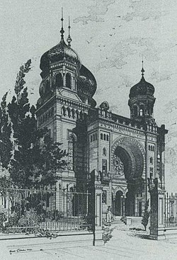
Synagogue (Kaiserslautern)
| synagogue | |
|---|---|
 Kaiserslautern synagogue |
|
| Data | |
| place | Kaiserslautern |
| architect | Ludwig Levy |
| Construction year | 1886 |
| demolition | 1938 |
| Floor space | 2440 m² |
The synagogue in Kaiserslautern was a synagogue on the square on today's Fischerstraße in Kaiserslautern , today's Synagogenplatz .
History and architecture
In 1848/49 the first synagogue in Kaiserslautern was built in Salzstrasse and was used until the new synagogue was built. The sale followed in 1886. From then on, the old synagogue served as a residential building until it was demolished in 1972.
The new synagogue, a Jewish sacred building domed with a bulging, compact and large drum dome, was built in the Moorish-Byzantine style according to plans by Ludwig Levy (1854–1907) from Karlsruhe and inaugurated in 1886.
The Kaiserslautern Synagogue was a central building in the form of a Greek cross that was placed in a square. Between the cross arms and the square there were " gusset spaces " or triangular rounded vault gussets or penditife , which were then connected to the arms of the cross as "aisles" . The vault gussets were necessary to close the gaps between the supporting arches of the middle four pillars that supported the dome. These four pillars were still reminiscent of the domed central structure based on the Byzantine floor plan of the Greek cross. But otherwise the synagogue in Kaiserslautern abandoned the central building scheme in favor of a "basilica" whose "aisles" were dedicated to the female parishioners. The central wing was emphasized here because Levy preferred this structure and decorated it with a mighty horseshoe arch that encompassed the rose window and the three-part portal. The horseshoe arch was cut deep into the masonry, which almost led to the facade being dissolved. This fact was reinforced by the fact that the side borders of the central wing were severely divided by many small windows.
Demolition and memorial
During the time of National Socialism , Kaiserslautern was to become the capital of the Gau . Today's Fischerstrasse (then Dr.-Frick- Strasse), which led directly past the synagogue, was intended as a parade route for marches. Mayor Richard Imbt used this as an excuse to demolish the synagogue, which according to his statement had never fit into the cityscape and which hinders the necessary measures to expand the street. The Jewish community was forced to sell the synagogue to the city, and after a farewell service was held in August 1938, the building was demolished on August 29, 1938 and finally blown up on October 9.
From 1980 there was a memorial stone on the site of the former synagogue, which covers 2440 m². In 2002, as part of the redesign of the square, a memorial was erected to commemorate the Jewish victims in Kaiserslautern during the Nazi era . The course of the former outer walls was reconstructed with box hedges and a two-part wall fragment, which had remained standing for days after the demolition, was rebuilt. The names of the victims can be read on the inside. Seven viewing devices allow a view of a virtual reconstruction of the synagogue.
See also
literature
- Hannelore Künzl: Islamic style elements in synagogue construction of the 19th and early 20th centuries . Publishing house Peter Lang, Frankfurt am Main u. a. 1984, ISBN 3-8204-8034-X (Judaism and Environment, 9). P. 402 ff.
- Ludwig Levy : Synagogue in Kaiserslautern . In: Deutsche Bauzeitung , vol. 25, no. 1 (January 3, 1891), p. 1 with illustrations on p. 4–5. ( urn : nbn: de: kobv: co1-opus-24540 )
Individual evidence
- ↑ a b c d Künzl, p. 402f
- ↑ Künzl, p. 283
- ↑ Heinz Friedel: Kaiserslautern - From the imperial era to the founding of the university. Kaiserslautern: Geschwister Schmidt Verlag, 1998. P. 99f.
- ↑ Memorials for the Victims of National Socialism, BpB series of publications, Bonn: 1987, p. 638.
Web links
Coordinates: 49 ° 26 ′ 39.9 ″ N , 7 ° 46 ′ 28.1 ″ E
