
List of administrative districts and cities in Rhineland-Palatinate
The state of Rhineland-Palatinate is subdivided into a total of 24 districts and 12 independent cities . This list of the districts and independent cities in Rhineland-Palatinate gives a general overview of these including their most important data. The current administrative structure of the country came about through the district reform from 1969 to 1974 , in which the previous 39 districts and 12 independent cities were restructured. What is unique is that the district of Germersheim has retained its structure (with a small exception on March 16, 1974) to this day.
With 19,854.2 square kilometers, the state of Rhineland-Palatinate is the ninth largest state in the Federal Republic of Germany . In terms of population, it ranks seventh with 4,093,903 people. The average population density is 206 inhabitants per square kilometer, although this can vary greatly within the individual districts. The population density in the city of Mainz is 2236 inhabitants per square kilometer, in the Rhein-Pfalz-Kreis 507 inhabitants per square kilometer and in the Eifelkreis Bitburg-Prüm only 61 inhabitants per square kilometer. The most populous district is the district of Mayen-Koblenz with 214,434 inhabitants, the least populous district of Vulkaneifel with 60,646 inhabitants. The largest independent city is Mainz with 218,578 inhabitants. The largest district in terms of area is the Eifelkreis Bitburg-Prüm, which, with 1,626.22 square kilometers, ranks 47th in terms of the size of the districts in Germany. The smallest district is the Rhein-Pfalz-Kreis with 304.92 square kilometers.
construction
The following list is structured as follows:
- District, independent city: Name of the district or the independent city
- District town: Name of the district town: The cell is empty for urban districts.
- Coat of arms: official coat of arms of the district or the independent city
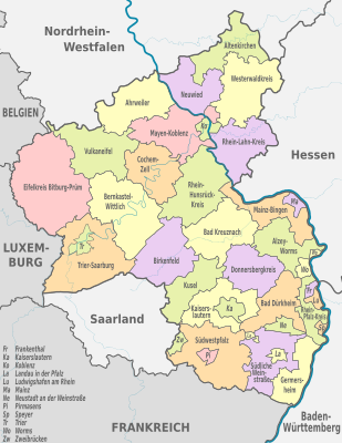
- Location: Location map of the districts or cities within the state of Rhineland-Palatinate
- Motor vehicle: vehicle registration number of the respective regional authority
- Ew: Population of the respective regional authority as of December 31, 2019
- Area: Area of the respective regional authority in square kilometers (km²)
- Ew / km²: population density in inhabitants per square kilometer
- Remarks: further information on geographic features of the respective cities and districts is listed, including mountains, rivers and larger lakes
- Image: a typical image from the region with which the respective regional authority is identified
Overview
| District / urban district |
County seat | coat of arms | location | Vehicle | Ew | Area (in km²) |
Ew / km² | Remarks | image |
|---|---|---|---|---|---|---|---|---|---|
| Ahrweiler | Bad Neuenahr-Ahrweiler |

|

|
AW | 130.086 | 786.98 | 165 | borders on North Rhine-Westphalia ; Rivers: Rhine and Ahr ; Parts of the Eifel in the district area |

|
| Altenkirchen (Westerwald) | Altenkirchen (Westerwald) |

|

|
AK | 128,805 | 641.99 | 201 | borders on North Rhine-Westphalia ; Rivers: Sieg , Wied and Nister ; Westerwald's Siegerland |

|
| Alzey-Worms | Alzey |

|

|
AZ | 129,687 | 588.15 | 220 | borders on Hessen ; River: Rhine ; Alzeyer Hügelland , parts of Rheinhessische Schweiz |

|
| Bad Dürkheim | Bad Dürkheim |

|

|
DÜW | 132,671 | 594.76 | 223 | Palatinate , parts of the Palatinate Forest |

|
| Bad Kreuznach | Bad Kreuznach |

|

|
KH | 158.345 | 863.76 | 183 | River: Nahe ; Hunsrück , Rheinhessen , North Palatinate Uplands |

|
| Bernkastel-Wittlich | Wittlich |

|

|
WIL, BKS | 112,483 | 1,167.56 | 96 | River: Moselle ; Eifel , Hunsrück , highest mountain in Rhineland-Palatinate Erbeskopf |

|
| Birch field | Birch field |

|

|
BIR | 80,951 | 776.58 | 104 | borders on the Saarland ; River: Nahe ; Hunsrück ; Westrich |

|
| Cochem cell | Cochem |

|

|
COC, ZEL | 61,375 | 692.33 | 89 | River: Moselle ; Eifel , Hunsrück |
|
| Donnersbergkreis | Kirchheimbolanden |

|

|
KIB, ROK | 75,325 | 645.52 | 117 | River: Alsenz ; Nordpfälzer Bergland , Palatinate Forest ; highest mountain in the Palatinate Donnersberg |

|
| Eifel district Bitburg-Prüm | Bitburg |

|

|
BIT, PRÜ | 99.058 | 1,626.22 | 61 | Largest district in terms of area in Rhineland-Palatinate; until the end of 2006 called "Bitburg-Prüm"; borders on Belgium and Luxembourg and on North Rhine-Westphalia ; Rivers: Kyll , Nims , Prüm , Our and Sauer ; Eifel |

|
|
Frankenthal (Pfalz) (independent city) |

|

|
FT | 48,762 | 43.76 | 1114 | River: Isenach ; Upper Rhine Plain |

|
|
| Germersheim | Germersheim |

|

|
GER | 129.013 | 463.35 | 278 | borders on France and Baden-Württemberg ; Rivers: Rhine , Lauter ; Upper Rhine Graben |

|
|
Kaiserslautern (independent city) |

|
.svg)
|
KL | 100.030 | 139.74 | 716 | River: Louder ; Palatinate Forest |

|
|
| Kaiserslautern | Kaiserslautern |

|
.svg)
|
KL | 105,979 | 639.88 | 166 | borders on the Saarland ; River: Louder ; Palatinate Forest , North Palatinate Uplands |

|
|
Koblenz (independent city) |

|

|
KO | 114.052 | 105.13 | 1085 | Rivers: Rhine and Moselle ( Deutsches Eck ); Foothills of the Maifeld , the Westerwald and the Hunsrück |

|
|
| Kusel | Kusel |

|

|
KUS | 70.219 | 573.28 | 122 | borders on the Saarland ; Rivers: Lauter and Glan ; North Palatinate Uplands |

|
|
Landau in der Pfalz (independent city) |

|

|
LD | 46,881 | 82.96 | 565 | Palatinate Forest , Upper Rhine Plain |

|
|
|
Ludwigshafen am Rhein (independent city) |

|

|
LU | 172.253 | 77.55 | 2221 | borders on Baden-Wuerttemberg and forms a dual center with the directly adjacent Baden-Wuerttembergian Mannheim ; River: Rhine ; Upper Rhine Graben |

|
|
|
Mainz (independent city) |

|

|
MZ | 218,578 | 97.74 | 2236 | State capital, largest city in Rhineland-Palatinate; borders on Hesse and forms a double center with the directly adjacent Hessian Wiesbaden ; River: Rhine |

|
|
| Mainz-Bingen | Ingelheim am Rhein |

|
.svg)
|
MZ , BIN | 211,417 | 605.77 | 349 | borders on Hessen ; Rivers: Rhine and Nahe ; Rheinhessen |

|
| Mayen-Koblenz | Koblenz |

|

|
MYK, MY | 214,434 | 817.25 | 262 | most populous district of Rhineland-Palatinate; Rivers: Rhine , Moselle , Nette and Elzbach ; Westerwald , Maifeld , Pellenz |

|
|
Neustadt an der Weinstrasse (independent city) |

|

|
NW | 53,264 | 117.1 | 455 | River: Speyerbach ; Haardt , Upper Rhine Plain |

|
|
| Neuwied | Neuwied |

|

|
NO | 182.811 | 626.9 | 292 | borders on North Rhine-Westphalia ; Rivers: Rhine , Wied ; Westerwald |

|
|
Pirmasens (independent city) |

|
.svg)
|
PS | 40.231 | 61.37 | 656 | Palatinate Forest |

|
|
| Rhein-Hunsrück district | Simmern / Hunsrück |

|

|
SIM, GOA | 103.163 | 991.12 | 104 | River: Rhine ; Hunsrück |

|
| Rhein-Lahn district | Bad Ems |

|

|
EMS, DIZ, GOH | 122.297 | 782.29 | 156 | borders on Hessen ; Rivers: Rhine and Lahn ; Westerwald and Taunus |

|
| Rhine-Palatinate District | Ludwigshafen am Rhein |

|

|
RP | 154,609 | 304.92 | 507 | smallest district of Rhineland-Palatinate in terms of area; borders on Hesse and Baden-Württemberg ; River: Rhine ; until 2003 district of Ludwigshafen |

|
|
Speyer (independent city) |

|

|
SP | 50,561 | 42.6 | 1187 | borders on Baden-Württemberg ; Rivers: Rhine and Speyerbach ; Upper Rhine Plain |

|
|
| Southern Wine Route | Landau in the Palatinate |

|

|
SOUTH | 110,521 | 639.83 | 173 | borders on France ; Rivers: Lauter and Queich ; Palatinate Forest and Upper Rhine Plain ; is on the German Wine Route |

|
| Southwest Palatinate | Pirmasens |

|
.svg)
|
PS , ZW | 94,831 | 953.65 | 99 | borders on France and the Saarland ; Source of the Lauterbach; Palatinate Forest and Westrich plateau |

|
|
Trier (independent city) |

|
.svg)
|
TR | 111,528 | 117.13 | 952 | River: Moselle ; Foothills of the Hunsrück and the Eifel |

|
|
| Trier-Saarburg | trier |

|
.svg)
|
TR, SAB | 149,398 | 1,101.49 | 136 | borders on Luxembourg and the Saarland ; Rivers: Moselle , Sauer , Saar Ruwer ; Hunsrück |

|
| Vulkaneifel | Down |

|

|
DAU | 60,646 | 911.02 | 67 | least populous district in Rhineland-Palatinate; until the end of 2006 designation of the Daun district ; borders on North Rhine-Westphalia ; River: Kyll ; Eifel |

|
| Westerwaldkreis | Montabaur |

|

|
WW | 201.904 | 988.95 | 204 | borders on North Rhine-Westphalia and Hesse ; Rivers: nisters ; Wied and Sayn ; Westerwald ; was created in 1974 from the Unterwesterwaldkreis and Oberwesterwaldkreis districts |

|
|
Worms (independent city) |

|

|
WHERE | 83,542 | 108.73 | 768 | borders on Hessen ; Rivers: Rhine ; Awl ; Upper Rhine Plain |

|
|
|
Zweibrücken (independent city) |

|

|
ZW | 34.193 | 70.64 | 484 | borders on the Saarland ; Rivers: Schwarzbach ; Hornbach ; Westrich |

|
|
| Rhineland-Palatinate | 4,093,903 | 19,854.2 | 206 | ||||||
See also
Individual evidence
- ↑ State Statistical Office of Rhineland-Palatinate - population status 2019, districts, communities, association communities ( help on this ).
- ↑ Territorial status: Territorial area in square kilometers - reference date 31.12. - Regional depth: municipalities, joint / association municipalities (accessed online on February 23, 2016)