
Schwarzbach (Blies)
|
Schwarzbach in the headwaters also Burgalb |
||
 River course |
||
| Data | ||
| Water code | DE : 26426 | |
| location | Germany | |
| River system | Rhine | |
| Drain over | Blies → Saar → Moselle → Rhine → North Sea | |
| Burgalbursprung | on the western slope of Steinberg 49 ° 19 ′ 35 ″ N , 7 ° 48 ′ 48 ″ E |
|
| Source height | approx. 432 m above sea level NHN | |
| muzzle | for Einöd from the left into the Blies coordinates: 49 ° 15 '55 " N , 7 ° 18' 27" E 49 ° 15 '55 " N , 7 ° 18' 27" E |
|
| Mouth height | approx. 220 m above sea level NHN | |
| Height difference | approx. 212 m | |
| Bottom slope | approx. 4.2 ‰ | |
| length | 50.6 km, with moss ointment 62.8 km | |
| Catchment area | 1,151.548 km² | |
| Discharge at the Contwig A Eo gauge: 529.6 km². Location: 9.5 km above the mouth |
NNQ (08.08.1976) MNQ 1953–2007 MQ 1953–2007 Mq 1953–2007 MHQ 1953–2007 HHQ (21.12.1993) |
550 l / s 2.26 m³ / s 5.03 m³ / s 9.5 l / (s km²) 24.4 m³ / s 60.3 m³ / s |
| Runoff at the Einöd gauge |
NNQ MNQ MQ MHQ HHQ |
4.14 m³ / s 5.41 m³ / s 10.4 m³ / s 94 m³ / s 220 m³ / s |
| Left tributaries | → tributaries | |
| Right tributaries | → tributaries | |
| Flowing lakes | Burgalbweiher, horse fountain pond, Schwarzbachtalweiher | |
| Reservoirs flowed through | Clausensee | |
| Medium-sized cities | Zweibrücken , Homburg | |
| Communities | Leimen , Waldfischbach-Burgalben , Thaleischweiler-Föschen , Rieschweiler-Mühlbach , Dellfeld , Contwig | |
 Schwarzbach in Zweibrücken |
||
The Schwarzbach , also called Burgalb in the headwaters , is a 50 km long left tributary of the Blies , in whose catchment area the states of Rhineland-Palatinate and Saarland have a share. In addition to most of the Zweibrücker Westrich, the Schwarzbach with its tributaries drains the entire western Palatinate Forest and, along with Lauter (on the upper reaches of Wieslauter ), Queich and Speyerbach, is one of the four major drainage systems of this low mountain range .
geography
course


The Schwarzbach has three spring brooks that arise south of the hamlet Johanniskreuz in the central Palatinate Forest west of the Palatinate main watershed . The northernmost of the three springs, which are at about 432 m above sea level. NHN immediately fills the 40 m long and 15 m wide Burgalbweiher , is considered the main source and, marked with the knight stone 101, is called the Burgalbursprung . The southeastern one is the horse fountain at about 438 m altitude ( ⊙ ). The third and most southerly source is the Teufelsbrunnen ( ⊙ ) located at a height of 415 m , which feeds a 250 m short left tributary from the south to the brook from the horse fountain. The three arise at a distance of no more than one kilometer northwest, south and southwest of the 527.9 m high Steinberg summit. The south-running source stream from the Burgalbursprung and the branch of the so-called Pferdsbach, which flows westwards together with its longer source branch, which causes the drainage of the other two sources, unite after about one kilometer each and with partial catchment areas of around 2.5 km² each to around 370 m height in the 30 m long and 12 m wide horse fountain pond to the Schwarzbach. The place is referred to by the Ritterstein No. 245 as the Schwarzbach origin.
The Schwarzbachtal, which is up to 200 m deep, runs north and west of Leimen in a generally south-westerly direction. The first large pond that the Schwarzbach flows through is the 175 m long and up to 45 m wide Schwarzbachtalweiher . The Ramschelbach flows here from the left of the Groß-Kirch valley . Later the Rauschenbach flows from the left , and below the dammed Clausensee from the right the Hundsbächel and the Dinkelsbächel follow . At Waldfischbach-Burgalben , where the Schwarzbach leaves the closed forest area , the Moosalbe , which is around three times as powerful and 12 km longer and is usually called Moosalb on site , flows from the north to the right . At the hamlet of Biebermühle , the Rodalb flows in from the south-east, at Thaleischweiler-Fröschen, the Wallhalb flows from the right from the north . Via Rieschweiler-Mühlbach , Dellfeld - this is where the Schwarzbach valley ends - and Contwig , the Schwarzbach reaches Zweibrücken , where the Auerbach flows from the right and then the Hornbach, which is on a par with the Schwarzbach, from the left .
About 1.5 km after crossing the border to Saarland, the Schwarzbach flows into the Blies from the left in the Homburg district of Einöd , which reaches the Saar after another 45 km . At the confluence of the Schwarzbach, with 10.7 m³ / s, it has a little more than twice as much water as the Blies, whose value above the confluence is 5 m³ / s. At its mouth, the Schwarzbach is a few kilometers shorter than the Blies.
Tributaries
- Pferdsbach ( left ), 0.7 km
- Hölzenklingbächel ( left ), 0.8 km
- Ramschelbach ( left ), 3.3 km
- Kleinkirchtalbach ( left ), 1.8 km
- Schleifenbächel ( left ), 1.3 km
- (Bach am Fallensteig) ( left ), 0.4 km
- Hahnenseybach ( right ), 2.5 km
- (Bach im Staatsforst Johannis) ( right ), 0.5 km
- (Bach am Rappersborner Fels) ( right ), 0.6 km
- Rauschenbach ( left ), 1.7 km
- Hermersbächel ( right ), 0.9 km
- Hundsbächel ( right ), 4.2 km
- Dinkelsbächel ( right ), 1.9 km
- Hollertalbach ( left ), 1.4 km
- (Bach am Forsthaus Heidelsburg) ( left ), 0.1 km
- Dietersbach ( left ), 1.3 km
- Moosalbe ( right ), 16.4 miles
- Klapperbach ( right ), 5.3 km
- Schorbächel ( right ), 1.6 km
- Rodalb ( left ), 25.8 km
- (Bach from the Alschbacher Klamm) ( right ), 0.5 km
- (Stream from the Rieslochklamm ) ( right ), 2.4 km
- (Bach vom Kühlbrunnen) ( left ), 0.4 km
- Höhfröschener Bach ( left ), 2.2 km
- Small frog pit ( left ), 0.3 km
- Runzenbach ( right ), 0.4 km
- Wallhalbe ( right ), (with Stuhlbach ) 18.7 km
- Floßbach ( right ), 0.8 km
- Mohrbach ( left ), 2.0 km
- Hintersbach ( right ), 2.1 km
- Jägerbach ( right ). 2.5 km
- Marbach ( right ), 1.2 km
- Aschbach ( left ), 5.8 km
- (Bach vom Weihertalkopf) ( left ), 0.8 km
- Wahlbach ( left ), 0.1 km
- (Bach vom Ehringer Wald) ( left ), 0.5 km
- Stambach ( right ), 2.8 km
- Hohlbach ( right ), 1.7 km
- (Bach am Mühlberg) ( left ), 1.1 km
- Contwiger Graben ( right ), 1.0 km
- Gartengraben ( right ), 0.4 km
- Wiesengraben ( right ), 0.2 km
- (Waters at Bettelmannsfels) ( right ), 0.4 km
- Fasaneriebach ( left ), 0.9 km
- Auerbach ( right ), 16.5 km
- Bombach ( right ), 2.3 km
- Bleichenbach ( left ), 1.0 km
- (Bach from the source of Ernstweiler) ( right ), 1.1 km
- Bautzenbach ( Jammertalbach ) ( right ), 3.7 km
- Hornbach ( left ), 32.8 km
- Dörmersklamm ( left )
- Hungerbergbach ( left )
- Kandelgrundbach ( right )
Floodplain sediments
In the floodplains of the Schwarzbach and its tributaries, a total of around 52.7 million tons of sandy - loamy floodplain sediments are stored , which result from an average soil removal of 9.3 to 15.5 cm in the entire catchment area. Forest clearance and historical agriculture are assumed to be the cause .
Attractions
All of the sights listed below are located in the Schwarzbachtal or on the heights that surround it.
Hundsweihersägemühle
The former sawmill is located on the Hundsbächel a little above its confluence with the Schwarzbach. There is a campsite there, and there is a restaurant by the brook that has become the Hundsweiher . Hiking trails lead through the Heltersberg Forest to the eponymous local community .
Heidelsburg
From the Sommerdelle car park there are opportunities to climb to the ruins of the Heidelsburg castle, which dates back to Roman times and is about 60 m higher on the right above the valley. The mostly narrow gravel paths or forest paths lead up steeply and, depending on the time of year and the number of people used, can show growth.
Saltuarius
On the site of the Heidelsburg, the stone grave relief of a Saltuarius , a Roman forest manager, was excavated.
Red sandstone rocks
The parking spaces in the Schwarzbachtal can also be used as a starting point for hikes to the sometimes bizarrely shaped red sandstone rocks in the forests north of the Schwarzbach. These include the Kasimirfels that after Pfalzgraf Johann Casimir is named, the soul rock to its name, local legends have grown, and the basket maker rock with its splendid fountain, where once Korbmacher their willow branches before braiding watered.
Clausensee
The 4.5 hectare large and up to 5 m deep Clausensee , whose water quality is considered to be above average, has an island in its middle. It has a camping area and a (unguarded) beach. A sea festival is held annually on the last weekend in July.
Heraldic forge
The former heraldic forge, whose iron hammer was driven by the Schwarzbach, is located on a bridge over the brook. From here hiking trails lead to the pilgrimage site of Maria Rosenberg and to Clausen .
German Schuhstrasse
Part of the middle Schwarzbach is on Deutsche Schuhstrasse . This was set up in 1977 to remind people that the surrounding Pirmasens region was the center of the German shoe industry from the beginning of the 19th century .
Steinenschloss Castle
On a southern spur to the right above the confluence of the Schwarzbach and Rodalb rivers are the ruins of Steinenschloss Castle , which was built around the year 1100.
Schwarzbachtal Bridge
Between the hamlet of Biebermühle and Thaleischweiler-Fröschen, the Schwarzbachtal is spanned by the 700 m long and 100 m high Schwarzbachtal Bridge, the longest bridge structure on Autobahn 62 .
White storks
In the meadows of Rieschweiler-Mühlbach on the lower Schwarzbach, white storks settled again in the second half of the 1990s . For several years, a webcam of the Pfalzstorch campaign was installed near a nest in the Höhmühlbach district .
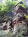
Rock formation at the Heidelsburg

Heidelsburg, west gate

Grave relief of Saltuarius
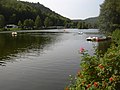
Clausensee to the west (in the direction of flow of the Schwarzbach)
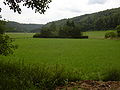
Schwarzbachtal near Waldfischbach-Burgalben

Steinenschloss Castle

Schwarzbachtal Bridge (A 62)

Schwarzbach in Zweibrücken


_neu.jpg)

Economy and Infrastructure
economy
In the past, forestry and later also the shoe industry were dominant economic sectors in the Schwarzbach area, but today tourism is increasingly used as a source of income. In particular, the area of the middle Schwarzbach on the approximately 25 km between the confluence of the Hundsbächel and the local community Dellfeld is marketed under the name Schwarzbachtal .
traffic
With the exception of the first 10 km, the Schwarzbach is accompanied by public roads. Above Burgalben this is the county road 32 leading to Leimen , between Waldfischbach-Burgalben and Biebermühle the federal road 270 ( Kaiserslautern - Pirmasens ). State road 477 then runs to Dellfeld , below federal road 10 along the Schwarzbach; To the south, parallel to this, the Zweibrücken –Pirmasens section of the Autobahn 8 was built in the 1970s .
The Biebermühlbahn (Kaiserslautern – Pirmasens) runs along the Schwarzbach between Waldfischbach-Burgalben and Biebermühle , and the Landau – Rohrbach railway line between Biebermühle and its confluence with the Blies .
2.5 km north of Rieschweiler-Mühlbach is the small Pottschütthöhe airfield on the Sickinger Höhe . It is approved for airplanes, helicopters and balloons up to ten tons and is operated by three air sports clubs.
Web links
- Hiking tours in the Schwarzbach area: Tour 40 , Tour 56 , Tour 61
- Schwarzbach gauge Contwig
Individual evidence
- ↑ a b Map service of the landscape information system of the Rhineland-Palatinate Nature Conservation Administration (LANIS map) ( notes )
- ↑ Measurement based on the German base map 1: 5000
- ↑ a b Measurement on topographic map 1: 25,000.
- ↑ GeoExplorer of the Rhineland-Palatinate Water Management Authority ( information )
- ↑ Contwig gauge, data from LfU Rhineland-Palatinate.
- ↑ ( Page no longer available , search in web archives: level data of the Saarland. )
- ↑ Hornbach discharge volume. Retrieved January 9, 2012 .
- ↑ Flow characteristics of Schwarzbach and Hornbach. (No longer available online.) Archived from the original on July 26, 2011 ; Retrieved January 9, 2012 .
- ↑ Schwarzbach discharge volume. Retrieved January 9, 2012 .
- ↑ It flows into the Froschgraben, a tributary of the Schwarzbach.
- ^ Right source stream.
- ↑ Christian Stolz: Budgeting soil erosion from floodplain and alluvial fan sediments in the western Palatinate Forest (Pfälzerwald, Germany) . In: Journal of Geomorphology . NF 55, 4, 2011, ISSN 0372-8854 , p. 437-461 (English).
- ↑ Brunnenwanderweg. (PDF; 5.57 MB) (No longer available online.) Heltersberg community, archived from the original on January 4, 2014 ; Retrieved November 4, 2010 .
- ^ Website ( memento from October 19, 2012 in the Internet Archive ) of Aktion Pfalzstorch , Bornheim.