Höhmühlbach
|
Höhmühlbach
Local community Rieschweiler-Mühlbach
Coordinates: 49 ° 14 ′ 32 " N , 7 ° 31 ′ 28" E
|
||
|---|---|---|
| Height : | 255 m above sea level NHN | |
| Residents : | 752 (Jun 30, 2007) | |
| Incorporation : | 7th June 1969 | |
|
Location of Höhmühlbach in Rhineland-Palatinate |
||
|
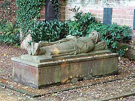
Höhmühlbach war memorial
|
||
Höhmühlbach is the smaller of two districts of the local community Rieschweiler-Mühlbach in the district of Südwestpfalz in Rhineland-Palatinate . Until 1969 it was an independent community.
location
Höhmühlbach is located on the Westrich plateau in the eastern municipality. It is located in the Schwarzbachtal . The eponymous river runs in an east-west direction immediately north of the settlement area. To the north-west of the development there is also a natural monument, the thick oak . One kilometer northwest of Höhmühlbach is the neighboring village of Rieschweiler.
history
The place originated in the early Middle Ages. Until the end of the 18th century, Höhmühlbach belonged to Pfalz-Zweibrücken . From 1798 to 1814, when the Palatinate was part of the French Republic (until 1804) and then part of the Napoleonic Empire , the place - then called Hochmühlbach - was incorporated into the canton of Pirmasens and was subordinate to the Mairie Ninschweiler . In 1815 the place had 160 inhabitants. In the same year, Austria was struck. Just one year later, the place, like the entire Palatinate, changed to the Kingdom of Bavaria . From 1818 to 1862 he was a member of the Pirmasens Land Commissioner ; from this the district office of Pirmasens emerged.
In 1928 Höhmühlbach had 513 residents who lived in 49 residential buildings. Both the Catholics and the Protestants belonged to the parish of Nünschweiler at the time . From 1938 the place was part of the district of Pirmasens . After the Second World War , Höhmühlbach became part of the then newly formed state of Rhineland-Palatinate within the French occupation zone . In the course of the first Rhineland-Palatinate administrative reform , Höhmühlbach was merged on June 7, 1969 with the neighboring municipality of Rieschweiler to form the new local municipality of Rieschweiler-Mühlbach ; At the same time the place moved to the district of Zweibrücken . With its dissolution three years later, the place again fell to the district of Pirmasens, which was renamed in 1997 in the district of Südwestpfalz .
Culture
In Höhmühlbach there is a war memorial whose figure of a lying, dead soldier, the famous sculpture by Bernhard Bleeker in the Hofgarten war memorial , is modeled in front of the Bavarian State Chancellery in Munich . The original marble figure from Munich has been in the Bavarian Army Museum in Ingolstadt since 1972 and has been replaced by a bronze cast . With the aforementioned war memorial, the Rieschweiler mill, the Protestant church and a residential building on Pirmasenser Strasse, there are a total of four objects on site that are listed .
Transport and infrastructure
Höhmühlbach has a stop on the Landau – Rohrbach railway line , which is located on the northern edge of the settlement. It was created after the Second World War and was expanded between 2008 and 2009. This was connected to a 55 centimeter high platform and a bus shelter. There are hourly connections to Pirmasens in the east and to Zweibrücken , Sankt Ingbert and Saarbrücken in the west. Before that, Rieschweiler station had been the closest train stop since 1875. State road 477 also runs north of the settlement area in an east-west direction .
After the Second World War, the place was also part of the Pirmasens Military Community, which has now been dissolved . In addition, a portable fire pump from the community fire brigade is stationed here. There is also a kindergarten in Höhmühlbach. With the SV Rot-Weiss 1930 Höhmühlbach there is also a football club. At times there was a Protestant school on site.
Individual evidence
- ↑ vgtw.de: Rieschweiler-Mühlbach . Retrieved May 25, 2018 .
- ↑ a b daten.digitale-sammlungen.de: List of localities for the Free State of Bavaria . Retrieved October 9, 2015 .
- ↑ General Directorate for Cultural Heritage Rhineland-Palatinate (ed.): Informational directory of cultural monuments - District of Südwestpfalz. Mainz 2020, p. 38 (PDF; 8.7 MB).
- ↑ Contents of the municipal council meeting of June 4, 2008 ( Memento of July 14, 2014 in the Internet Archive )
- ↑ Railroad cycling - railroad routes in Rhineland-Palatinate. In: pfaelzischer-merkur.de. Retrieved July 6, 2014 .
- ^ Teams of the club. In: fussball.de. DFB GmbH, accessed on May 25, 2018 .

