
Moss ointment (Schwarzbach)
|
Moosalbe on site also Moosalb |
||
 Karlstal the moss ointment |
||
| Data | ||
| Water code | DE : 264262 | |
| location | Germany | |
| River system | Rhine | |
| Drain over | Schwarzbach → Blies → Saar → Moselle → Rhine → North Sea | |
| source | west of Johanniskreuz 49 ° 20 ′ 3 ″ N , 7 ° 49 ′ 3 ″ E |
|
| Source height | 403 m above sea level NHN | |
| muzzle | in Waldfischbach-Burgalben from the right in the Schwarzbach coordinates: 49 ° 16 '46 " N , 7 ° 38' 50" E 49 ° 16 '46 " N , 7 ° 38' 50" E |
|
| Mouth height | 248 m above sea level NHN | |
| Height difference | 155 m | |
| Bottom slope | 6 ‰ | |
| length | 25.8 km, with Aschbach 30.3 km | |
| Catchment area | 188.174 km² | |
| Left tributaries | Hasendellbach, Meiserbach , Hirschalbe, Seetalbach | |
| Right tributaries | Kottelbach, Kaltenborn, Aschbach , Schweinsbach, Engtalbach , Queidersbach | |
| Reservoirs flowed through | Wooge of the middle hammer and the under hammer | |
| Communities | Trippstadt , Stelzenberg , Schopp , Steinalben , Waldfischbach-Burgalben | |
The Moosalbe (so according to the official topographical map) or Moosalb (so often on site) is a flowing body of water in the West Palatinate ( Rhineland-Palatinate ) and a right tributary of the Schwarzbach . The upper Moosalbtal is also called Hammertal because of its industrial monuments to iron smelting and iron processing , because there were hammer mills that were driven with the Moosalb water. In the course of the upper valley is identical to the tourist offices Karlstal .
geography
course

The moss ointment rises in the heart of the Palatinate Forest 400 m west of the Palatinate main watershed at an altitude of 403 m . To the east of its source is the hamlet of Johanniskreuz , which belongs to the municipality of Trippstadt and through which federal road 48 leads from Hochspeyer in the north to the Queich valley in the south.
First, the moss ointment flows to the northwest and west through the Palatinate Forest. In this area it is dammed up to form a few woogens that were once created as water storage for the hammer mills. After 11 km it breaks through the western edge of the Palatinate Forest and bends almost at a right angle to the southwest, with its floodplain now separating the Palatinate Forest in the east from the Sickinger Höhe in the west. The federal highway 270 ( Kaiserslautern - Pirmasens ) and the corresponding railway line run parallel to the water .
After a run of almost 26 km , the Moosalbe flows into Waldfischbach-Burgalben at an altitude of 248 m from the right as a three times stronger body of water into the Schwarzbach, which is also called Burgalb (e) up to this point.
Tributaries
The strongest inflow of the moss ointment is the 14.6 km long Aschbach , which - like the moss ointment coming from the Palatinate Forest - flows into the Karlstal train station from the right and at this point the moss ointment is halfway through and 4.5 km long surpasses. South of Schopp - also from the Palatinate Forest - the 6.5 km long Hirschalb (e) flows from the left , at Steinalben the 10.7 km long Queidersbach flows from the right , which has its origin on the Sickinger Höhe.
Attractions
Unterhammer - As a former iron hammer mill, the Unterhammer plant is a memorial from the beginnings of Palatine industrial history in the 18th century.
Klug'sche Mühle - The historic Klug'sche Mühle on the Moosalbe, near the lower end of the Karlstal, was converted into a restaurant during the restoration. Before it came into the possession of the Klug family in 1842, whose descendants still manage it today, it was called Wilensteiner Mühle .
Karlstal - From the mouth of the Aschbach river up the moosalb one arrives at the Karlstal , a largely natural rocky narrow valley about 4 km long.
Amseldell - On the left slope of the Karlstal there is a formerly inhabited rock cave and further up the Amseldell , a now dilapidated leisure facility from the 19th century, which was originally equipped with a maze , a bowling alley , a shooting range and a pavilion .
Wilenstein Castle - To the right above the Karlstal lies the partially restored Wilenstein Castle , which was built in the middle of the 12th century, on a rock spur at a height of 350 m . Today's Burg Wilenstein youth home is a school camp and accommodates school classes and youth groups.
Protestant Church Trippstadt - The baroque Trippstadt Church was built in 1744/45 on the foundations of the Gothic predecessor church.
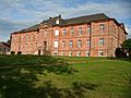
Trippstadt Castle - The Trippstadt Castle , built in baroque style from the region's red sandstone , was built from 1764 to 1767 according to plans and under the direction of the Zweibrücken architect Sigmund Jacob Haeckher . The associated palace park was originally laid out in a strictly geometric style in the Versailles style and was much larger than it is today.
Brunnenstollen - The Trippstadter Brunnenstollen was completed in 1767. The system, which was built using the counter-site tunnel method in antiquity , supplied the community with drinking water until 1965 . The well tunnel is a unique monument in Europe .
Ironworks Museum - The Ironworks Museum Trippstadt documents the iron smelting , the heyday of which the community experienced around the middle of the 19th century.
Sculpture Trail - The Rhineland-Palatinate Sculpture Trail runs with its sections Trippstadt – Stelzenberg and Karlstal in the area of the upper Moosalbe.

Moss ointment in Karlstal

Wilenstein Castle

Baroque church Trippstadt
Trippstadt Castle
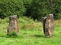
Karlstal sculpture trail


Web links
- Karlstalschlucht der Moosalbe on www.trippstadt.de
Individual evidence
- ↑ a b c d Map service of the landscape information system of the Rhineland-Palatinate nature conservation administration (LANIS map) ( notes )
- ↑ a b GeoExplorer of the Rhineland-Palatinate Water Management Authority ( information )
- ↑ Unterhammer in Karlstal. Unterhammer im Karlstal, accessed on March 15, 2015 .
- ^ The Amseldell near Trippstadt. Trippstadt municipality, accessed on September 25, 2015 .
- ↑ Trippstadt Baroque Palace. Trippstadt municipality, accessed on March 15, 2015 .
- ↑ Eisenhüttenmuseum Trippstadt. Trippstadt municipality, accessed on March 15, 2015 .
- ↑ Sculpture Path . Trippstadt municipality, accessed on March 16, 2015 .