
Westerwaldkreis
| coat of arms | Germany map |
|---|---|

|

Coordinates: 50 ° 33 ' N , 7 ° 52' E |
| Basic data | |
| State : | Rhineland-Palatinate |
| Administrative headquarters : | Montabaur |
| Area : | 988.95 km 2 |
| Residents: | 201.904 (Dec. 31, 2019) |
| Population density : | 204 inhabitants per km 2 |
| License plate : | WW |
| Circle key : | 07 1 43 |
| NUTS : | DEB1B |
| Circle structure: | 192 parishes |
| Address of the district administration: |
Peter-Altmeier-Platz 1 56410 Montabaur |
| Website : | |
| District Administrator : | Achim Schwickert ( CDU ) |
| Location of the Westerwaldkreis in Rhineland-Palatinate | |
  |
|
The Westerwaldkreis is a regional authority in northern Rhineland-Palatinate and lies between Cologne / Bonn and the Frankfurt / Rhine-Main metropolitan region . The town of Montabaur is the seat of the district administration and at the same time the most populous municipality . The district was created in 1974 as part of the Rhineland-Palatinate regional and administrative reform from the simultaneously dissolved districts of Unterwesterwaldkreis (based in Montabaur) and Oberwesterwaldkreis (based in Westerburg ).
geography
The area of the Westerwaldkreis was calculated in 2014 according to the district administration of the Westerwaldkreis as 988.97 and according to the State Statistical Office of Rhineland-Palatinate as 988.98 square kilometers. The north-south extension is 44 kilometers and the west-east extension 40 kilometers. The highest point is the Fuchskaute at 657 m above sea level. NN , the lowest point at 150 m is in the Gelbachtal below Dies , a district of Gackenbach .
location
The Westerwaldkreis is located in northern Rhineland-Palatinate, not far from the border triangle with Hesse and North Rhine-Westphalia . The district extends over the Westerwald northeast of Koblenz . It is relatively sparsely populated. Larger rivers are the Nister , the Wied and the Sayn , which, however, leave the district area just a few kilometers after the source.
climate
The Westerwald , despite its relatively low altitude for a typical low mountain bracing climate . The average annual temperature is between 6.5 and 8.5 degrees Celsius. The average annual rainfall is between 780 and 1300 millimeters. Around 40 percent of the district is forested.
Neighboring areas
The Westerwaldkreis borders in a clockwise direction in the northeast on the Siegen-Wittgenstein district (in North Rhine-Westphalia ), the Lahn-Dill district and the Limburg-Weilburg district (both in Hesse ) as well as the Rhein-Lahn district , to the Independent city of Koblenz and the districts of Mayen-Koblenz , Neuwied and Altenkirchen (Westerwald) (all in Rhineland-Palatinate).
history
Before 1800, today's district was divided into numerous rulers, of which the Electorate of Trier and the Principality of Nassau-Orange had the largest shares. After that, the area came to the Duchy of Nassau from 1806/1815 and in 1866 it was annexed by Prussia . Then the three districts of Unterwesterwaldkreis (seat in Montabaur), Oberwesterwaldkreis (seat in Bad Marienberg ) and Westerburg were created . In 1932 the northern part of the Westerburg district with the city of Westerburg was incorporated into the Oberwesterwaldkreis, the district seat of which was moved from Bad Marienberg to Westerburg. The southern part of the Westerburg district came to the Unterwesterwaldkreis. The districts belonged to the Wiesbaden administrative district of the Hesse-Nassau province . On August 30, 1946, both districts came to Rhineland-Palatinate and initially belonged to the administrative district of Montabaur . After its dissolution in 1968, both districts were assigned to the Koblenz administrative district. In 1970 Marienhausen moved from the Unterwesterwaldkreis to the Neuwied district and Berod bei Hachenburg from the Oberwesterwaldkreis to the Altenkirchen district. As part of the district reform , both districts were merged on March 16, 1974 to form the Westerwald district, which was given its current name on August 1, 1974 (with the exception of Arzbach , which is now part of the Rhein-Lahn district , and Stromberg, today a district of Bendorf in the Mayen-Koblenz district ).

Nassau offices from 1816 in today's district area

Prussian districts 1867/1886 to 1932 in today's district area

Prussian or Rhineland-Palatinate districts 1932 to 1974 in today's district area

Association communities in today's district


population
| year | Residents | source |
|---|---|---|
| 1975 | 165,800 | |
| 1980 | 167,700 | |
| 1990 | 178,100 | |
| 2000 | 201,800 | |
| 2010 | 198,580 | |
| 2018 | 201,597 |
The residents are generally considered Westerwald called, the locals call themselves Wäller or basalt Koeppe , as they are considered stubborn and in a very basalt live rich region. As of December 31, 2019, the Westerwaldkreis had 201,904 inhabitants. The population density on the reference date was 204 inhabitants per square kilometer. At the end of 2013 there were more women (50.5 percent) than men (49.5 percent) in the district. At 32.5 percent, the old-age quotient slightly exceeds the youth quotient (32.1 percent).
The proportion of foreigners (registered residents without German citizenship ) was 6.2 percent on December 31, 2013 (12,263 people). The most strongly represented nationalities are primarily Turkish , Polish , Italian , Kosovar , Russian , Bulgarian , Bosnian and Herzegovinian , Romanian , Dutch and Croatian .
In March 2015, the district recorded an unemployment rate of 4.2 percent (4651 people).
politics

Politically, the Westerwaldkreis is conservative . This can also be seen in the dominant position of the CDU, which is by far the strongest force and continues to provide the district administrator after successful re-election in 2017. In the 2019 district election, however, like the SPD, it suffered significant losses. The winners of the election are the AfD, who appeared for the first time, as well as the Greens and FDP, which corresponds to the general state trend in the local elections in Rhineland-Palatinate.
District council
The district council of the Westerwaldkreis consists of 50 honorary district council members elected in a personalized proportional representation and the district administrator as chairman. After the last district election on May 26, 2019 , the following distribution of seats results:
| year | SPD | CDU | AfD | FDP | Green | left | FWG | NPD | total |
|---|---|---|---|---|---|---|---|---|---|
| 2019 | 10 | 18th | 4th | 3 | 7th | 2 | 6th | - | 50 |
| 2014 | 14th | 22nd | - | 2 | 4th | 2 | 6th | - | 50 |
| 2009 | 15th | 21st | - | 4th | 3 | 1 | 5 | 1 | 50 |
| 2004 | 14th | 26th | - | 2 | 3 | - | 5 | - | 50 |
| 1999 | 18th | 24 | - | 2 | 2 | - | 4th | - | 50 |
- Free voter group Westerwald (FWG) e. V.
Due to the peculiarities of the Rhineland-Palatinate electoral system in local elections ( personalized proportional representation ), the percentage of votes shown in the graphic are shown as “weighted results” that can only represent the voting behavior arithmetically.
District Administrator
Achim Schwickert (CDU) has held the position of district administrator since October 11, 2009; in the district election on May 7, 2017, he was confirmed in office for a further eight years with 88.87% of the votes. The district administrator is also the head of the authority and the chairman of the district board, chairman of the district council and external representative of the district. Representatives of the district council include the members of the district executive, Kurt Schüler (first district member) as well as Ulrich Keßler and Thomas Roth (both district members).
- Former district administrators
- 1974–1984: Norbert Heinen
- 1985–2009: Peter Paul Weinert
District administration
The district administration of the Westerwald district consists of three departments with and nine departments (one as a self-propelled ). Numerous sections and specialist areas are subordinate to the departments .
badges and flags
Hoist flag

Banner flag

The Westerwaldkreis has a coat of arms as well as a hoist and banner flag .
|
|
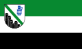
Blazon : “In silver, a green sloping bar; Growing below seven silver-edged, hexagonal black basalt columns of different heights, above a cylindrical, old German blue jug with silver ribs and three oval silver medallions. " |
|
Justification for the coat of arms: The seven basalt columns stand for the seven association communities in which basalt and quartz occur, while the jug with the three medallions symbolizes the three association communities of the so-called Kannenbäckerland , which is home to the pottery and the ceramic industry. The green sloping bar symbolizes the recreational value of the district with its forests and meadows.
The coat of arms was approved on February 2, 1976. |
economy
In terms of nominal gross domestic product, the Westerwaldkreis is one of the economically strongest districts in Rhineland-Palatinate. In 2010 the district generated a nominal 5.4 billion euros - this is the highest rate in all Rhineland-Palatinate districts. The city of Montabaur and the Wallmerod community each have the highest per capita purchasing power in the district and their values are higher the national average.
In 2012 around 29,000 people commuted to work beyond the Westerwaldkreis, while around 17,000 people commuted to work in the district. The majority of those employees who left the district mainly went to Koblenz, the Hessian district of Limburg-Weilburg and the district of Altenkirchen (Westerwald) . The commuters come in particular from the districts of Altenkirchen, Neuwied and the Rhein-Lahn district .
In the Future Atlas 2016 , the Westerwaldkreis ranked 215th out of 402 rural districts, municipal associations and urban districts in Germany, making it one of the regions with a “balanced risk-opportunity mix” for the future. In the 2019 edition, it was ranked 217 out of 401.
traffic
Rail transport

The traffic-remote area of the Westerwald was only opened up at the end of the 19th century by railway lines that - with the exception of a small railway - were built by the Prussian State Railway . Since 2002, the Westerwald has been connected to the national and international long-distance transport network through the Montabaur train station on the high-speed route Cologne – Rhine / Main with a few stops. The ICE connects the Limburg Süd train station in the southeast , the Frankfurt airport long-distance train station and the Frankfurt main train station . In the opposite direction of the ICE connects the Siegburg / Bonn station , the Cologne Main Station and the Köln Messe / Deutz station and Brussels .
In 1884 the Unterwesterwaldbahn was opened from Limburg via Montabaur to Altenkirchen, from which a line branched off in Siershahn to Engers am Rhein, which in Grenzau received a branch to Höhr-Grenzhausen, which was only extended to Hillscheid in 1911. The second line from Limburg to Altenkirchen via Hadamar –Westerburg was put into operation only two years later - in 1886.
From 1906 a branch line ran from Herborn in the Lahn-Dill district to Rennerod and in 1907 it reached Westerburg. The Erbach – Fehl-Ritzhausen railway, which opened in 1911 and branched off from the Oberwesterwaldbahn Altenkirchen – Westerburg – Limburg, also ran into it.
The eastern north-south line was connected to the western parallel line in 1910 by the Westerburg – Montabaur railway line.
Another cross-connection had already been created in 1901 by the narrow-gauge line of the Kleinbahn-AG Selters-Hachenburg .
In 1907 the town of Höhr-Grenzhausen received - along with an extension in 1910 - an electric overland line to Vallendar on the Rhine from the Coblenz tram company ; this was replaced by a trolleybus in 1941 .
Of the railway network, which from 1911 - i.e. excluding the 25 km new line - comprised around 185 km, today only 66 km are used by passenger trains. This traffic was taken over by the Vectus Verkehrsgesellschaft at the end of 2004 . The transport contract with the former transport company Vectus ended with the timetable change in December 2014. From December 2014, the Hessische Landesbahn , Dreiländerbahn operating area , took over the transport services on the RB 29 (Unterwesterwaldbahn) and on the RB 90 (Westerwald-Sieg-Bahn), which were used for the timetable change 2015 was extended from Au (Sieg) über Wissen and Betzdorf to Siegen . The Au an der Sieg station is an important transfer station for travelers from the Oberwesterwald in the direction of Bonn, Cologne and Aachen, this is where the S12 line of the Cologne S-Bahn (Düren - Horrem - Cologne - Siegburg / Bonn - Herchen - Au) ends (Sieg)), the Rhein-Sieg-Express (RE 9) runs from Au (Sieg) to Siegen and in the opposite direction to Siegburg / Bonn train station , to Cologne, Düren and Aachen.
Since January 1, 2017, the Westerwaldkreis has been applying the tariff of the Verkehrsverbund Rhein-Mosel (VRM) for bus and train tickets .
Passenger traffic settings:
- 1950: Herschbach - Hachenburg 19 km (meter gauge)
- 1959: Herborn - Rehe - Rennerod 6 km (Westerwaldquerbahn)
- 1960: Selters - Herschbach 5 km (meter gauge)
- 1971: Fehl-Ritzhausen - Bad Marienberg - Erbach 12 km
- 1972: Grenzau - Höhr-Grenzhausen - Hillscheid 7 km
- 1981: Rennerod - Fehl-Ritzhausen - Westerburg 17 km ( Westerwaldquerbahn )
- 1981: Montabaur - Wallmerod - Westerburg 26 km (Westerwaldquerbahn)
- 1984: Siershahn - Selters - Altenkirchen 40 km (of which 12 km in the Westerwaldkreis) ( Holzbachtalbahn )
- 1989: Engers - Grenzau - Siershahn 28 km (15 km of which in the Westerwaldkreis) ( Brexbachtalbahn )
Trunk roads
The federal highways 3 ( Cologne - Frankfurt am Main ) and the 48 (Koblenz – Montabaur) run through the district . In addition, the district is accessed by several federal highways, including the B 8 , B 49 , B 54 , B 255 , B 413 and B 414 .
At the beginning of the 21st century, efforts were made to better connect the Westerwaldkreis to the motorway network. The route discussed under the name “Westerwaldautobahn” would have connected the A 48 near Dernbach with the A 45 near Freudenberg , thereby significantly improving the traffic situation in the Hachenburg community and the Altenkirchen district . Nevertheless, the Westerwald motorway was not realized due to considerable protests.
Administrative structure
The Westerwaldkreis comprises ten association communities with 192 local communities . The largest municipality is the city of Montabaur with 13,998 inhabitants, the smallest local municipality is Heuzert with 118 inhabitants.

Association municipalities
| Association municipality | Population (December 31, 2019) |
|---|---|
| Bad Marienberg (Westerwald) | 19,358 |
| Hachenburg | 24,285 |
| Höhr-Grenzhausen | 13,433 |
| Montabaur | 40,130 |
| Ransbach-Baumbach | 15,024 |
| Rennerod | 16,745 |
| Selters (Westerwald) | 16,150 |
| Wallmerod | 14,587 |
| Westerburg | 22,670 |
| Wirges | 19,522 |
Local parishes
The administrative offices of the municipalities are marked with an asterisk (*).
| Local parish | Population (December 31, 2019) |
Association municipality |
|---|---|---|
| Bad Marienberg (Westerwald) , city * | 6,098 | Bad Marienberg (Westerwald) |
| Boelsberg | 217 | Bad Marienberg (Westerwald) |
| Dreisbach | 570 | Bad Marienberg (Westerwald) |
| Fehl-Ritzhausen | 766 | Bad Marienberg (Westerwald) |
| Large soaps | 634 | Bad Marienberg (Westerwald) |
| Hahn near Marienberg | 477 | Bad Marienberg (Westerwald) |
| Hardt | 456 | Bad Marienberg (Westerwald) |
| court | 1,196 | Bad Marienberg (Westerwald) |
| Kirburg | 580 | Bad Marienberg (Westerwald) |
| Langenbach near Kirburg | 1,080 | Bad Marienberg (Westerwald) |
| Lautzenbrücken | 432 | Bad Marienberg (Westerwald) |
| Mörlen | 527 | Bad Marienberg (Westerwald) |
| Neunkhausen | 1,021 | Bad Marienberg (Westerwald) |
| Nisterau | 821 | Bad Marienberg (Westerwald) |
| Nesting valley | 1,192 | Bad Marienberg (Westerwald) |
| Norken | 946 | Bad Marienberg (Westerwald) |
| Stockhausen-Illfurth | 444 | Bad Marienberg (Westerwald) |
| Imprecise | 1,901 | Bad Marienberg (Westerwald) |
| Alpenrod | 1,579 | Hachenburg |
| Aster | 224 | Hachenburg |
| Atzel poison | 607 | Hachenburg |
| Borod | 506 | Hachenburg |
| Dreifelden | 250 | Hachenburg |
| Gehlert | 614 | Hachenburg |
| Giesenhausen | 322 | Hachenburg |
| Hachenburg , city * | 6.122 | Hachenburg |
| Hatters | 1,748 | Hachenburg |
| Heimborn | 259 | Hachenburg |
| Hay concert | 118 | Hachenburg |
| Höchstenbach | 697 | Hachenburg |
| Kroppach | 689 | Hachenburg |
| Kundert | 253 | Hachenburg |
| Limbach | 416 | Hachenburg |
| Linden trees | 143 | Hachenburg |
| Lochum | 321 | Hachenburg |
| Luckenbach | 656 | Hachenburg |
| Marzhausen | 254 | Hachenburg |
| Merkelbach | 419 | Hachenburg |
| Mörsbach | 434 | Hachenburg |
| Mudenbach | 713 | Hachenburg |
| Mündersbach | 770 | Hachenburg |
| Müschenbach | 990 | Hachenburg |
| Nest | 1,050 | Hachenburg |
| Rossbach | 826 | Hachenburg |
| Steinebach on the Wied | 836 | Hachenburg |
| Stein-Wingert | 238 | Hachenburg |
| Arguing houses | 501 | Hachenburg |
| Voting rod | 867 | Hachenburg |
| Welkenbach | 142 | Hachenburg |
| Wied | 486 | Hachenburg |
| Winkelbach | 235 | Hachenburg |
| Hilgert | 1,507 | Höhr-Grenzhausen |
| Hillscheid | 2,426 | Höhr-Grenzhausen |
| Höhr-Grenzhausen , City * | 9,261 | Höhr-Grenzhausen |
| Kammerforst | 239 | Höhr-Grenzhausen |
| ground | 584 | Montabaur |
| Daubach | 462 | Montabaur |
| Eitelborn | 2,440 | Montabaur |
| Gackenbach | 534 | Montabaur |
| Girod | 1,173 | Montabaur |
| Goergeshausen | 873 | Montabaur |
| Großholbach | 965 | Montabaur |
| Heilberscheid | 655 | Montabaur |
| Heiligenroth | 1,390 | Montabaur |
| Holler | 1.006 | Montabaur |
| Horbach | 658 | Montabaur |
| Huebingen | 530 | Montabaur |
| Kadenbach | 1,327 | Montabaur |
| Montabaur , city * | 13,998 | Montabaur |
| Nentershausen | 1.997 | Montabaur |
| Neuhäusel | 2,034 | Montabaur |
| Niederelbert | 1,700 | Montabaur |
| Niedererbach | 1,023 | Montabaur |
| Nomborn | 719 | Montabaur |
| Oberelbert | 1,164 | Montabaur |
| Ruppach-Goldhausen | 1,257 | Montabaur |
| Simmer | 1,474 | Montabaur |
| Stahlhofen | 732 | Montabaur |
| Untershausen | 487 | Montabaur |
| Welschneudorf | 948 | Montabaur |
| Alsbach | 636 | Ransbach-Baumbach |
| Breitenau | 704 | Ransbach-Baumbach |
| Caan | 705 | Ransbach-Baumbach |
| Deesen | 668 | Ransbach-Baumbach |
| Hundsdorf | 435 | Ransbach-Baumbach |
| Nauort | 2,209 | Ransbach-Baumbach |
| Oberhaid | 389 | Ransbach-Baumbach |
| Ransbach-Baumbach , City * | 7,783 | Ransbach-Baumbach |
| Sessenbach | 503 | Ransbach-Baumbach |
| Wirscheid | 329 | Ransbach-Baumbach |
| Wittgert | 663 | Ransbach-Baumbach |
| Board houses | 200 | Rennerod |
| Elsoff (Westerwald) | 910 | Rennerod |
| Hellenhahn-Schellenberg | 1,217 | Rennerod |
| Homberg (Westerwald) | 176 | Rennerod |
| Hüblingen | 295 | Rennerod |
| Irmtraut | 767 | Rennerod |
| Love divorce | 834 | Rennerod |
| Neunkirchen (Westerwald) | 544 | Rennerod |
| Neustadt / Westerwald | 577 | Rennerod |
| Niederroßbach | 686 | Rennerod |
| Nister-Möhrendorf | 298 | Rennerod |
| Oberrod | 651 | Rennerod |
| Oberroßbach | 351 | Rennerod |
| deer | 964 | Rennerod |
| Rennerod , city * | 4,398 | Rennerod |
| Salzburg | 221 | Rennerod |
| Seck | 1,150 | Rennerod |
| Stein-Neukirch | 408 | Rennerod |
| Waigandshain | 198 | Rennerod |
| Forest mills | 336 | Rennerod |
| Western ear | 909 | Rennerod |
| Willingen (Westerwald) | 271 | Rennerod |
| Zehnhausen near Rennerod | 384 | Rennerod |
| Ellenhausen | 285 | Selters (Westerwald) |
| Ewighausen | 233 | Selters (Westerwald) |
| Freilingen | 669 | Selters (Westerwald) |
| Freirachdorf | 626 | Selters (Westerwald) |
| Goddert | 452 | Selters (Westerwald) |
| Hartenfels | 774 | Selters (Westerwald) |
| Herschbach | 2,800 | Selters (Westerwald) |
| Crumbs | 319 | Selters (Westerwald) |
| Marienrachdorf | 984 | Selters (Westerwald) |
| Maroth | 255 | Selters (Westerwald) |
| Maxsain | 1,060 | Selters (Westerwald) |
| Nordhofen | 532 | Selters (Westerwald) |
| Quirnbach | 484 | Selters (Westerwald) |
| Rückeroth | 487 | Selters (Westerwald) |
| Schenkelberg | 642 | Selters (Westerwald) |
| Selters (Westerwald) , city * | 2,814 | Selters (Westerwald) |
| Sessenhausen | 893 | Selters (Westerwald) |
| Stones | 241 | Selters (Westerwald) |
| Vielbach | 541 | Selters (Westerwald) |
| Willow cock | 571 | Selters (Westerwald) |
| Wolferlingen | 488 | Selters (Westerwald) |
| Arnshöfen | 147 | Wallmerod |
| Berod near Wallmerod | 542 | Wallmerod |
| Bilkheim | 482 | Wallmerod |
| Three churches | 1.014 | Wallmerod |
| Elbingen | 324 | Wallmerod |
| Ettinghausen | 327 | Wallmerod |
| Hahn am See | 393 | Wallmerod |
| Herschbach (Oberwesterwald) | 893 | Wallmerod |
| Dog chants | 2,056 | Wallmerod |
| Cow farms | 165 | Wallmerod |
| Moravia | 206 | Wallmerod |
| Meudt | 1,895 | Wallmerod |
| Molsberg | 460 | Wallmerod |
| Niederahr | 817 | Wallmerod |
| Oberahr | 537 | Wallmerod |
| Obererbach | 489 | Wallmerod |
| salt | 835 | Wallmerod |
| Stone frenzy | 796 | Wallmerod |
| Wallmerod * | 1,438 | Wallmerod |
| Weroth | 586 | Wallmerod |
| Zehnhausen near Wallmerod | 185 | Wallmerod |
| Ailertchen | 594 | Westerburg |
| Bellingen | 600 | Westerburg |
| Berzhahn | 494 | Westerburg |
| Brandscheid | 476 | Westerburg |
| Enspel | 267 | Westerburg |
| Gemünden | 984 | Westerburg |
| Girkenroth | 600 | Westerburg |
| Peep home | 939 | Westerburg |
| Half | 355 | Westerburg |
| Härtlingen | 375 | Westerburg |
| Hergenroth | 421 | Westerburg |
| Heck | 3,018 | Westerburg |
| Kaden | 581 | Westerburg |
| Koelbingen | 1.009 | Westerburg |
| Langenhahn | 1,394 | Westerburg |
| Pottum | 1,056 | Westerburg |
| Rotenhain | 519 | Westerburg |
| Rothenbach | 907 | Westerburg |
| Stahlhofen am Wiesensee | 334 | Westerburg |
| Stockum puffs | 639 | Westerburg |
| Weltersburg | 310 | Westerburg |
| Westerburg , City * | 5,657 | Westerburg |
| Willmenrod | 656 | Westerburg |
| Win | 485 | Westerburg |
| Bannberscheid | 656 | Wirges |
| Dernbach (Westerwald) | 2,473 | Wirges |
| Boar cock | 1,252 | Wirges |
| Helferskirchen | 1,208 | Wirges |
| Leuterod | 838 | Wirges |
| Mogendorf | 1,286 | Wirges |
| Moschheim | 718 | Wirges |
| Niedersayn | 161 | Wirges |
| Ötzingen | 1,381 | Wirges |
| Siershahn | 2,887 | Wirges |
| Staudt | 1,242 | Wirges |
| Wirges , city * | 5,420 | Wirges |
For lists on the term "area changes" see area reforms in Rhineland-Palatinate .
License Plate
On August 1, 1974, the district was assigned the distinctive sign MT , which had been valid since July 1, 1956 for the Unterwesterwaldkreis . It was derived from the district town of Montabaur. In 1976, today's distinguishing mark WW was introduced, which is still the only mark issued to this day.
The district administration of the Westerwaldkreis vehemently rejects the reintroduction of the old license plates MT (Montabaur or Unterwesterwaldkreis) and WEB (Westerburg or Oberwesterwaldkreis), because the district administrator sees "the WW license plate as a strong sign of identification with the entire region". A reintroduction would, according to District Administrator Schwickert, "open up the old rifts between the former Oberwesterwaldkreis (WEB) and the former Unterwesterwaldkreis (MT)".
See also
Web links
|
Further content in the sister projects of Wikipedia:
|
||
|
|
Commons | - multimedia content |
|
|
Wiktionary | - Dictionary entries |
|
|
Wikivoyage | - Travel Guide |
- Official website of the Westerwaldkreis
- Statistical data of the Westerwaldkreis at the State Statistical Office of Rhineland-Palatinate
- Literature about the Westerwaldkreis in the catalog of the German National Library
- Literature about Westerwaldkreis in the Rhineland-Palatinate state bibliography
Individual evidence
- ↑ a b State Statistical Office of Rhineland-Palatinate - population status 2019, districts, municipalities, association communities ( help on this ).
- ↑ a b c Westerwald: Land - people - ideas. District brochure 2014 edition (PDF; 1.68 MB ) District administration of the Westerwaldkreis, accessed on April 21, 2015 .
- ↑ a b c My district, my independent city - Westerwaldkreis. State Statistical Office of Rhineland-Palatinate, accessed on April 21, 2015 .
- ↑ Westerwald. Ministry of Economy, Climate Protection, Energy and State Planning Rhineland-Palatinate , accessed on April 21, 2015 .
- ↑ Official municipality directory (= State Statistical Office of Rhineland-Palatinate [Hrsg.]: Statistical volumes . Volume 407 ). Bad Ems February 2016, p. 156 (PDF; 2.8 MB).
- ↑ Statistical Yearbook for the Federal Republic of Germany 1977
- ↑ Statistical Yearbook for the Federal Republic of Germany 1981
- ↑ Statistical Yearbook for the Federal Republic of Germany 1992
- ↑ Statistical Yearbook for the Federal Republic of Germany 2002
- ↑ The Westerwald - home for travelers. Norddeutscher Rundfunk (NDR), accessed on April 19, 2015 .
- ↑ Reporting month March 2015 - Westerwaldkreis. Central statistics service of the Federal Employment Agency , accessed on April 19, 2015 .
- ^ The Regional Returning Officer RLP: Westerwaldkreis. Final result of the 2019 district council election. Accessed August 10, 2019 .
- ↑ Explanation by the Land Returning Officer on the "Weighted Result"
- ↑ District administration of the Westerwaldkreis: District election 2017. in the Westerwaldkreis. Retrieved August 10, 2019 .
- ↑ Dr. Birgit Hübbers: Rhineland-Palatinate regional: Westerwaldkreis. (PDF; 213 kB ) State Statistical Office Rhineland-Palatinate , accessed on April 19, 2015 .
- ↑ Statistics for the Westerwaldkreis: In Montabaur the purchasing power is highest. Rhein-Zeitung , October 17, 2013, accessed on April 21, 2015 .
- ↑ Future Atlas 2016. (No longer available online.) Archived from the original on October 2, 2017 ; accessed on March 23, 2018 .
- ↑ PROGNOS future atlas. Handelsblatt, accessed on December 10, 2019 .
- ↑ Westerwaldkreis joins community tariff. District council makes important decision. In: westerwaldkreis.de. District administration of the Westerwaldkreis, July 14, 2016, accessed on July 16, 2016 .
- ↑ Nature conservation in Rhineland-Palatinate. (No longer available online.) NABU - Naturschutzbund Deutschland e. V., archived from the original on December 13, 2014 ; accessed on April 23, 2015 .
- ↑ a b State Statistical Office of Rhineland-Palatinate - population status 2019, districts, municipalities, association communities ( help on this ).
- ↑ Circle rejects old tags MT and WEB. Rhein-Zeitung , August 23, 2012, accessed on April 9, 2015 .
Districts:
Ahrweiler |
Altenkirchen (Westerwald) |
Alzey-Worms |
Bad Dürkheim |
Bad Kreuznach |
Bernkastel-Wittlich |
Birkenfeld |
Cochem cell |
Donnersbergkreis |
Eifelkreis Bitburg-Prüm |
Germersheim |
Kaiserslautern |
Kusel |
Mainz-Bingen |
Mayen-Koblenz |
Neuwied |
Rhine-Hunsrück District |
Rhein-Lahn district |
Rhine-Palatinate District |
Southern Wine Route |
Southwest Palatinate |
Trier-Saarburg |
Vulkaneifel |
Westerwaldkreis
Independent cities:
Frankenthal (Pfalz) |
Kaiserslautern |
Koblenz |
Landau in the Palatinate |
Ludwigshafen am Rhein |
Mainz |
Neustadt an der Weinstrasse |
Pirmasens |
Speyer |
Trier |
Worms |
Zweibrücken