Stahlhofen am Wiesensee
| coat of arms | Germany map | |
|---|---|---|

|
Coordinates: 50 ° 35 ' N , 7 ° 59' E |
|
| Basic data | ||
| State : | Rhineland-Palatinate | |
| County : | Westerwaldkreis | |
| Association municipality : | Westerburg | |
| Height : | 430 m above sea level NHN | |
| Area : | 2.42 km 2 | |
| Residents: | 334 (Dec. 31, 2019) | |
| Population density : | 138 inhabitants per km 2 | |
| Postal code : | 56459 | |
| Area code : | 02663 | |
| License plate : | WW | |
| Community key : | 07 1 43 293 | |
| Association administration address: | Neumarkt 1 56457 Westerburg |
|
| Website : | ||
| Local Mayor : | Frank Butterweck | |
| Location of the local community Stahlhofen am Wiesensee in the Westerwaldkreis | ||
Stahlhofen am Wiesensee is a municipality in the Westerwaldkreis in Rhineland-Palatinate . Since 1972 it has belonged to the then newly formed community of Westerburg .
geography
Stahlhofen am Wiesensee is located 3 km northeast of Westerburg , on a hill near the western bank of the Wiesensee . The municipality includes the residential places Forellenhof, in Roeder Hahn, Winner banks and camping Wiesensee.
Neighboring communities are: Halbs , Hergenroth , Höhn , Pottum and Winnen .
history
Stahlhofen belonged to Westerburg until the beginning of the 19th century and came to the Grand Duchy of Berg in 1806 as the Rhine Confederation was formed under Napoleon . In 1813 Stahlhofen came temporarily to the House of Orange-Nassau and as a result of the Congress of Vienna in 1815 to the Duchy of Nassau . Under the Nassau administration, the municipality of Stahlhofen belonged to the lordship of Leiningen-Westerburg in the Rennerod office . In 1858 there were 41 families with 159 inhabitants in Stahlhofen. In 1866 the Duchy of Nassau and with it Stahlhofen became part of the Kingdom of Prussia .
The community was given the name “am Wiesensee” on January 1, 1975.
- Population development
The development of the population of Stahlhofen am Wiesensee, the values from 1871 to 1987 are based on censuses:
|
|
politics
Municipal council
The council Stahlhofen consists of eight council members, who in the local elections on May 26, 2019 in a majority vote were elected, and the honorary mayor as chairman.
mayor
Frank Butterweck became the local mayor of Stahlhofen am Wiesensee on August 16, 2019. In the direct election on May 26, 2019, he was elected for five years with 78.13% of the vote.
Butterweck's predecessor Günther Raspel had held the office for 30 years.
coat of arms
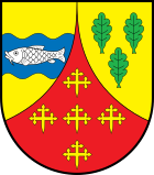
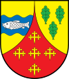
| Blazon : "Late Gothic round shield, split by a curved red tip, inside five golden three-leaf crosses set in a cross, a blue wavy bar in front in gold, inside a silver fish, behind in gold three green oak leaves." | |
| Justification for the coat of arms: The green oak leaves represent the inherited forest "Eigenwald" of the communities Stahlhofen, Halbs and Hergenroth . The forest represents a special form of ownership. The property inherited from Westerburg is still owned by families from the communities today. The blue wave bar with the fish stands for the Wiesensee and the Seebach with the fish industry operated in them. The colors blue and gold create the connection to the Nassau house, to which Stahlhofen once belonged. The five golden crosses on a red background are taken from the coats of arms of the lower noble family of Heinrich von Stahlhofen, who had their headquarters in Stahlhofen. The color of the red tip refers to the Westerburg rule . |
Culture and sights
Buildings
- The listed old village school from 1830
- See also the list of cultural monuments in Stahlhofen am Wiesensee
Sports
The Wiesensee has a size of approx. 80 hectares and offers not only circular walks but also opportunities for swimming , sailing , surfing and fishing . There is also a golf course by the lake .
traffic
- The B 255 , which connects Montabaur and Herborn , runs north of the community .
- Stahlhofen is served by the bus line 116 (Rennerod - Westerburg - Montabaur - Neuhäusel - Koblenz) operated by Rhein-Mosel-Bus GmbH.
- The closest connection to the railway is the Westerburg station on the RB 90, Westerwald-Sieg-Bahn (Limburg (Lahn) - Diez-Ost - Elz - Westerburg - Hachenburg - Altenkirchen - Au (Sieg) - Wissen (Sieg) - Siegen) - Kreuztal). This is operated by the Hessische Landesbahn , operating area Dreiländerbahn according to the Rhineland-Palatinate cycle .
- The next motorway junction is Montabaur (40) on the A 3 Cologne - Frankfurt am Main , about 20 kilometers away.
Web links
- Website of the local community Stahlhofen am Wiesensee
- Local community Stahlhofen am Wiesensee on the website of the Verbandsgemeinde Westerburg
Individual evidence
- ↑ State Statistical Office of Rhineland-Palatinate - population status 2019, districts, communities, association communities ( help on this ).
- ↑ State Statistical Office Rhineland-Palatinate (ed.): Official directory of the municipalities and parts of the municipality. Status: January 2019 [ Version 2020 is available. ] . S. 82 (PDF; 3 MB).
- ^ Annals of the Association for Nassau Antiquities and Historical Research , Volume 10, 1870, p. 321 ( Google Books )
- ^ State and address manual of the Duchy of Nassau for the year 1859 , p. 118 ( www.dilibri.de )
- ↑ Official municipality directory (= State Statistical Office of Rhineland-Palatinate [Hrsg.]: Statistical volumes . Volume 407 ). Bad Ems February 2016, p. 188 (PDF; 2.8 MB).
- ↑ State Statistical Office Rhineland-Palatinate: Regional data.
- ^ The Regional Returning Officer Rhineland-Palatinate: Local elections 2019, city and municipal council elections
- ^ Frank Butterweck: Local elections 2019 / constitutive session. In: Wäller Wochenspiegel - Anzeiger for the Verbandsgemeinde Westerburg, edition 35/2019. Linus Wittich Medien GmbH, accessed on July 13, 2020 .
- ^ The Regional Returning Officer Rhineland-Palatinate: direct elections 2019. see Westerburg, Verbandsgemeinde, 20th line of results. Retrieved July 13, 2020 .
- ↑ Michael Wenzel: Farewell after 30 years as local chief in Stahlhofen am Wiesensee: Günther Raspel grew fond of the office. In: Westerwälder Zeitung. Mittelrhein-Verlag GmbH, Koblenz, August 16, 2019, accessed on July 13, 2020 .
- ↑ Description of the coat of arms of the municipality


