Ötzingen
| coat of arms | Germany map | |
|---|---|---|

|
Coordinates: 50 ° 30 ' N , 7 ° 50' E |
|
| Basic data | ||
| State : | Rhineland-Palatinate | |
| County : | Westerwaldkreis | |
| Association municipality : | Wirges | |
| Height : | 310 m above sea level NHN | |
| Area : | 5.98 km 2 | |
| Residents: | 1381 (Dec. 31, 2019) | |
| Population density : | 231 inhabitants per km 2 | |
| Postal code : | 56244 | |
| Primaries : | 02602, 02666 (Sainerholz) | |
| License plate : | WW | |
| Community key : | 07 1 43 060 | |
| LOCODE : | DE OTE | |
| Community structure: | 2 districts | |
| Association administration address: | Bahnhofstrasse 10 56422 Wirges |
|
| Website : | ||
| Local Mayor : | Ansgar Ritz | |
| Location of the local community Ötzingen in the Westerwaldkreis | ||
Ötzingen is a municipality in the Westerwaldkreis in Rhineland-Palatinate . It belongs to the Verbandsgemeinde Wirges .
geography
Geographical location
The village is located at the foot of the Malberg , a wooded volcanic cone , which is located in the area of the neighboring municipality of Moschheim . Other neighboring communities are Leuterod , Niederahr , Oberahr , Ettinghausen , Kuhnhöfen , Niedersayn and Helferskirchen . The Aubach , which rises in the Sainerholz district about 3 km away, meanders along the outskirts .
As in the rest of the so-called Kannenbäckerland , clay mining plays an important role in Ötzingen. A little outside of the village there is a matching production facility for world-famous clay mosaics.
Community structure
Sainerholz is run as a district of the community. Ötzingen also includes the Aubachhof, Siedlerhof Ehl, Jagdhaus and Waldhof am Breitenberg residential areas .
history
The name is derived from the Old High German Uitzingen and probably means something like "descendants of Uitzo or Utz". The ending "-ingen" suggests that at the time of the conquest of the land this area had already been cleared or no forest was found. Thus, the origin of the settlement can be classified between the end of the 6th and the 11th century.
- Around 1362: Ozingen
- Around 1385: Oezingin
- Around 1386: Oitzingen
- Around 1417: Oytzingen
- Around 1476: Uitzingen , Ober-Otzingen
- Around 1589: Oezingin
On March 20, 1971, the previously independent community of Sainerholz with 174 inhabitants was incorporated into Ötzingen.
- Population development
The development of the population in relation to today's area of the local community Ötzingen, the values from 1871 to 1987 are based on censuses:
|
|
religion
The vast majority of the population is Roman Catholic. In the village there is the subsidiary church Maria-Hilf, which belongs to the parish Leuterod ( Diocese of Limburg ). The approximately 200 Protestant Christians are looked after by the Evangelical Martin Luther Church Congregation in Wirges ( Evangelical Church in Hesse and Nassau ).
politics
Municipal council
The local council in Ötzingen consists of 16 council members who were elected in the local elections on May 26, 2019 in a personalized proportional representation, and the honorary local mayor as chairman.
The distribution of seats in the municipal council:
| choice | SPD | Flat share 1 | Flat share 2 | total |
|---|---|---|---|---|
| 2019 | - | 9 | 7th | 16 seats |
| 2014 | 4th | 12 | - | 16 seats |
| 2009 | 3 | 13 | - | 16 seats |
| 2004 | 4th | 12 | - | 16 seats |
mayor
Ansgar Ritz became the local mayor of Ötzingen in 2013. In the direct election on May 26, 2019, he was confirmed in office for another five years with a share of 67.15% of the vote.
Ritz's predecessor as local mayor was Alexander Hübinger, who held the office for a good 16 years.
coat of arms
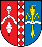
| Blazon : “Red and blue split by a silver stake covered with seven red cubes. In front, under a curved silver chapel gable with a bell tower, a silver oak leaf, behind a golden ear of wheat with two carpels, covered by a silver wavy strip. " | |
economy
To the west of the village is a clay mine and the Neubitz industrial park .
See also
Web links
Individual evidence
- ↑ State Statistical Office of Rhineland-Palatinate - population status 2019, districts, communities, association communities ( help on this ).
- ↑ State Statistical Office Rhineland-Palatinate (ed.): Official directory of the municipalities and parts of the municipality. Status: January 2019 [ Version 2020 is available. ] . S. 83 (PDF; 3 MB).
- ↑ Official municipality directory 2006 ( Memento from December 22, 2017 in the Internet Archive ) (= State Statistical Office Rhineland-Palatinate [Hrsg.]: Statistical volumes . Volume 393 ). Bad Ems March 2006, p. 192 (PDF; 2.6 MB). Info: An up-to-date directory ( 2016 ) is available, but in the section "Territorial changes - Territorial administrative reform" it does not give any population figures.
- ↑ State Statistical Office of Rhineland-Palatinate - Infothek
- ^ Bishopric Limburg, Maria, Hilfe der Christisten, Ötzingen . Retrieved January 8, 2011.
- ↑ Evangelical Martin Luther Church Congregation Wirges . Retrieved January 8, 2011.
- ^ The Regional Returning Officer Rhineland-Palatinate: Local elections 2019, city and municipal council elections
- ↑ a b Ansgar Ritz is the new local chief in Ötzingen. Westerwälder Zeitung, February 17, 2013, accessed on July 1, 2020 .
- ^ The Regional Returning Officer Rhineland-Palatinate: direct elections 2019. see Wirges, Verbandsgemeinde, eighth line of results. Retrieved July 1, 2020 .


