Niederahr
| coat of arms | Germany map | |
|---|---|---|

|
Coordinates: 50 ° 30 ' N , 7 ° 52' E |
|
| Basic data | ||
| State : | Rhineland-Palatinate | |
| County : | Westerwaldkreis | |
| Association municipality : | Wallmerod | |
| Height : | 300 m above sea level NHN | |
| Area : | 4.03 km 2 | |
| Residents: | 817 (Dec. 31, 2019) | |
| Population density : | 203 inhabitants per km 2 | |
| Postal code : | 56414 | |
| Area code : | 02602 | |
| License plate : | WW | |
| Community key : | 07 1 43 273 | |
| LOCODE : | DE ND4 | |
| Association administration address: | Richtstrasse 1 56414 Wallmerod |
|
| Website : | ||
| Local Mayor : | Jürgen Eulberg | |
| Location of the local community Niederahr in the Westerwaldkreis | ||
Niederahr is a municipality in the Westerwaldkreis in Rhineland-Palatinate . It belongs to the Wallmerod Association .
geography
The community is located in the Westerwald between Montabaur and Hachenburg . The Ahrbach flows through the village .
history
Niederahr was first mentioned in a document in 959.
politics
Municipal council
The municipal council in Niederahr consists of twelve council members who were elected by a majority vote in the local elections on May 26, 2019 , and the honorary local mayor as chairman.
mayor
Jürgen Eulberg became mayor of Niederahr on June 26, 2019. In the direct election on May 26, 2019, he was elected for five years with 87.30% of the vote.
Eulberg's predecessor Hermann Girhard had held the office for 15 years.
coat of arms
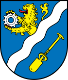
| Blazon : “Late Gothic round shield. On the left diagonally divided by a four-fold corrugated silver bar, above growing in blue a golden, red armored lion holding a silver gear, below in blue obliquely left a golden clay digger's spade. " | |
Economy and Infrastructure
traffic
- Federal highway 255 , which connects Montabaur and Rennerod , ran right through the town until 2016 . Since November 2016, the B 255 has been running on a bypass road around the town, which made headlines across the region due to a planning error: The pillar of a railway bridge built by Deutsche Bahn protrudes into the carriageway, so that instead of the planned three lanes only two could be implemented.
- The next motorway junction is Montabaur on federal motorway 3 ( Cologne - Frankfurt am Main ), about five kilometers away.
- The Montabaur train station on the Cologne – Rhein / Main high-speed line and the Unterwesterwaldbahn offer connections to long-distance traffic in the direction of Frankfurt and Cologne and the RB29 (Limburg (Lahn) - Diez Ost - Elz Süd - Montabaur - Wirges - Siershahn).
- Niederahr is located on the Westerwaldquerbahn (Herborn (Dillkreis) - Rennerod - Westerburg - Wallmerod - Montabaur), but only freight traffic between Montabaur and Wallmerod and excursion traffic with handcars between Westerburg and Rennerod take place on this railway line.
Established businesses
GEA Westfalia Separator produces decanters in the Niederahr plant .
See also
Web links
- Website of the local community Niederahr
- Local community Niederahr on the website of the Wallmerod community
Individual evidence
- ↑ State Statistical Office of Rhineland-Palatinate - population status 2019, districts, communities, association communities ( help on this ).
- ^ The Regional Returning Officer Rhineland-Palatinate: Local elections 2019, city and municipal council elections
- ↑ a b From the constituent meeting of the municipal council on June 26, 2019. In: We about us - Wallmerod Association, Edition 28/2019. Linus Wittich Medien GmbH, Höhr-Grenzhausen, accessed on July 6, 2020 .
- ^ The Regional Returning Officer Rhineland-Palatinate: direct elections 2019. see Wallmerod, Verbandsgemeinde, 15th line of results. Retrieved July 6, 2020 .


