Mörlen
| coat of arms | Germany map | |
|---|---|---|

|
Coordinates: 50 ° 42 ' N , 7 ° 53' E |
|
| Basic data | ||
| State : | Rhineland-Palatinate | |
| County : | Westerwaldkreis | |
| Association municipality : | Bad Marienberg (Westerwald) | |
| Height : | 416 m above sea level NHN | |
| Area : | 3.07 km 2 | |
| Residents: | 527 (Dec. 31, 2019) | |
| Population density : | 172 inhabitants per km 2 | |
| Postal code : | 57583 | |
| Area code : | 02661 | |
| License plate : | WW | |
| Community key : | 07 1 43 264 | |
| Association administration address: | Kirburger Strasse 4 56470 Bad Marienberg (Westerwald) |
|
| Website : | ||
| Local Mayor : | Thomas Ax | |
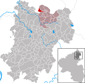
| Location of the local community Mörlen in the Westerwaldkreis | ||
Mörlen (dialect: Mörle, Mierlen ) is a municipality in the Westerwaldkreis in Rhineland-Palatinate . It belongs to the Bad Marienberg (Westerwald) community .
Geographical location
The community is located in the Westerwald between Limburg and Siegen. The place is located in a hollow on a southern slope to the stream of the Kleine Nister and is one of the most wooded communities in the Westerwaldkreis.
The Mühlengrund residential area also belongs to Mörlen .
history
The place is one of the oldest settlements in the Upper Westerwald . While the brook name Nigra Morlaha was first mentioned in 914/1048, the first documentary evidence can be found on November 13, 1262 in a document from the Abbey of Marienstatt .
- Population development
The development of the population of Mörlen, the values from 1871 to 1987 are based on censuses:
|
|
politics
Municipal council
The municipal council in Mörlen consists of twelve council members, who were elected in a personalized proportional representation in the local elections on May 26, 2019 , and the honorary local mayor as chairman. The twelve seats in the municipal council are divided between two groups of voters .
mayor
Thomas Ax became mayor of Mörlen in 2004. In the direct election on May 26, 2019, he was confirmed in his office for a further five years with a share of 77.78% of the votes.
Culture and sights
Buildings
The jewel of the place is the Catholic parish church of the Conception of Mary . It was built in 1866, expanded in 1882 and 1949 and fundamentally renovated in 2003.
Regular events
The traditional fair takes place every year on the first weekend in July .
traffic
- The B 414 runs south of the village and leads from Hohenroth to Hachenburg .
- The next motorway junction is Haiger-Burbach on the A 45 Dortmund - Gießen , about 27 kilometers away.
- The closest ICE stop is Montabaur train station on the Cologne – Rhein / Main high-speed line .
Web links
- The local community Mörlen on the website of the Verbandsgemeinde Bad Marienberg
- The website of the local community Mörlen
Individual evidence
- ↑ a b State Statistical Office of Rhineland-Palatinate - population status 2019, districts, municipalities, association communities ( help on this ).
- ^ Hermann Josef Hucke: Place names in the Westerwaldkreis in their dialect pronunciation as well as local nonsense. ( Memento of January 9, 2014 in the Internet Archive ) 2010, p. 3 (PDF; 132 kB).
- ↑ State Statistical Office Rhineland-Palatinate (ed.): Official directory of the municipalities and parts of the municipality. Status: January 2019 [ Version 2020 is available. ] . S. 72 (PDF; 3 MB).
- ↑ At that time the brook was the border of the mother parish Haiger , Kirburg its westernmost parish.
- ↑ State Statistical Office Rhineland-Palatinate: My village, my city. Retrieved May 30, 2020 .
- ^ The Regional Returning Officer Rhineland-Palatinate: Local elections 2019, city and municipal council elections.
- ^ Nadja Hoffmann-Heidrich: Election of the local mayor in the Bad Marienberg community on May 26th. Westerwälder Zeitung, February 27, 2019, accessed on June 4, 2020 .
- ^ The Regional Returning Officer Rhineland-Palatinate: direct elections 2019. see Bad Marienberg, Verbandsgemeinde, twelfth line of results. Retrieved June 4, 2020 .


