Elsoff (Westerwald)
| coat of arms | Germany map | |
|---|---|---|

|
Coordinates: 50 ° 35 ' N , 8 ° 7' E |
|
| Basic data | ||
| State : | Rhineland-Palatinate | |
| County : | Westerwaldkreis | |
| Association municipality : | Rennerod | |
| Height : | 370 m above sea level NHN | |
| Area : | 9.44 km 2 | |
| Residents: | 910 (Dec. 31, 2019) | |
| Population density : | 96 inhabitants per km 2 | |
| Postal code : | 56479 | |
| Area code : | 02664 | |
| License plate : | WW | |
| Community key : | 07 1 43 218 | |
| Community structure: | 2 districts | |
| Association administration address: | Hauptstrasse 55 56477 Rennerod |
|
| Website : | ||
| Mayoress : | Kornelia Jex | |
| Location of the local community Elsoff (Westerwald) in the Westerwaldkreis | ||
Elsoff (Westerwald) is a municipality in the Westerwaldkreis in Rhineland-Palatinate . It belongs to the Verbandsgemeinde Rennerod .
geography
Geographical location
The community is located in the Westerwald between the cities of Siegen (35 km north), Wetzlar (28 km east) and Limburg an der Lahn (22 km south). The highest elevations are the Heispel ( 418 m above sea level ) and the Zeitenberg ( 391 m above sea level ).
Neighboring communities
Neighboring communities are Westernohe in the northwest, Oberrod in the northeast, Mengerskirchen in the southeast, Neunkirchen in the south and Hüblingen in the southwest.
Community structure
The community is divided into the main town Elsoff and the town Mittelhofen. The district of Elsoff also includes the residential areas Brunhildenhof, Marienhof and Hof Ludwigshagen, the district of Mittelhofen includes the residential areas of Hof Krempel, Neumühle, Christinenhof, Niederfeldhof and Lindenhof.
history
On June 7, 1969, today's municipality of Elsoff was formed from the previously independent municipalities of Elsoff and Mittelhofen. On January 1, 1975 the addition to the name “(Oberwesterwaldkreis)” was changed to “(Westerwald)”.
- Population development
The development of the population of Elsoff in relation to today's municipality area; the values from 1871 to 1987 are based on censuses:
|
|
politics
Municipal council
The council in Elsoff (Westerwald) consists of twelve council members, who in the local elections on May 26, 2019 in a majority vote were elected, and the volunteer local mayor as chairman.
mayor
Kornelia Jex was confirmed in her office as local mayor for another five years in the direct election on May 26, 2019 with a share of the vote of 86.59%.
coat of arms
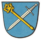
| Blazon : "In blue a golden crook , crossed with a fallen, silver sword." | |
Culture and sights
In Elsoff there are some listed cultural monuments.
- Elsoff
- The Catholic parish church of St. Peter and Paul, a three-aisled neo-Romanesque basalt stone hall, built in 1911; the tower is assigned to the Middle Ages.
- The Krempel farm, a former manor whose history goes back to the 15th century; the current parts of the building are from the 18th and 19th centuries.
- A saint's house from the 19th century (on the road to Mengerskirchen).
- A way of the cross , erected before 1898, together with a high cross from 1900 (northeast of the village at "Heispel").
- Mittelhofen
- The Catholic Chapel, a simple hall building from 1788 (Kapellenstrasse).
- A half-timbered house from the second half of the 18th century; on the house there is a cast iron fountain from the second half of the 19th century (Brunnenstrasse).
- A saint's house from the 19th century (north of the village).
- See also
List of cultural monuments in Elsoff (Westerwald)
traffic
- The B 54 runs west of the municipality and leads from Limburg an der Lahn to Siegen .
- The next motorway junction is Herborn on the A 45 Dortmund - Aschaffenburg , about 25 kilometers away.
- The closest ICE stops are Montabaur station and Limburg Süd station on the Cologne – Rhein / Main high-speed line .
Web links
- Website of the local community Elsoff (Westerwald)
- Information from the Verbandsgemeinde Rennerod about the local community Elsoff (Westerwald)
Individual evidence
- ↑ State Statistical Office of Rhineland-Palatinate - population status 2019, districts, communities, association communities ( help on this ).
- ↑ State Statistical Office Rhineland-Palatinate (ed.): Official directory of the municipalities and parts of the municipality. Status: January 2019 [ Version 2020 is available. ] . S. 78 (PDF; 3 MB).
- ↑ Official municipality directory (= State Statistical Office of Rhineland-Palatinate [Hrsg.]: Statistical volumes . Volume 407 ). Bad Ems February 2016, p. 163 (PDF; 2.8 MB).
- ↑ Official municipality directory (= State Statistical Office of Rhineland-Palatinate [Hrsg.]: Statistical volumes . Volume 407 ). Bad Ems February 2016, p. 186 (PDF; 2.8 MB).
- ↑ State Statistical Office Rhineland-Palatinate: My village, my city. Retrieved September 5, 2019 .
- ^ The Regional Returning Officer Rhineland-Palatinate: Local elections 2019, city and municipal council elections. Retrieved September 5, 2019 .
- ^ The Regional Returning Officer for Rhineland-Palatinate: direct elections 2019. see Rennerod, Verbandsgemeinde, second line of results. Retrieved July 16, 2020 .
- ^ General Directorate for Cultural Heritage Rhineland-Palatinate (ed.): Informational directory of cultural monuments - Westerwaldkreis. Mainz 2019, p. 10 f. (PDF; 4.8 MB).


