
Mengerskirchen
| coat of arms | Germany map | |
|---|---|---|

|
Coordinates: 50 ° 34 ' N , 8 ° 9' E |
|
| Basic data | ||
| State : | Hesse | |
| Administrative region : | to water | |
| County : | Limburg-Weilburg | |
| Height : | 420 m above sea level NHN | |
| Area : | 30.82 km 2 | |
| Residents: | 5639 (Dec. 31, 2019) | |
| Population density : | 183 inhabitants per km 2 | |
| Postal code : | 35794 | |
| Area code : | 06476 | |
| License plate : | LM, WEL | |
| Community key : | 06 5 33 011 | |
| LOCODE : | DE MKI | |
| Address of the municipal administration: |
Schloßstraße 3 35794 Mengerskirchen |
|
| Website : | ||
| Mayor : | Thomas Scholz ( CDU ) | |
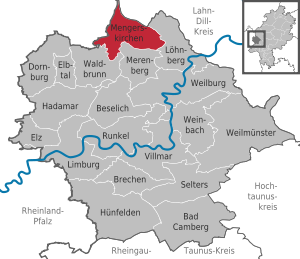
| Location of the municipality Mengerskirchen in the Limburg-Weilburg district | ||
  |
||

The market town Mengerskirchen is a municipality in the Limburg-Weilburg district in Central Hesse .
geography
Neighboring communities
Mengerskirchen is located in the Westerwald and borders in the north on the community Greifenstein ( Lahn-Dill-Kreis ), in the east on the community Löhnberg , in the south on the communities Merenberg and Waldbrunn (all three in the district Limburg-Weilburg), and in the west on the Municipalities Neunkirchen , Elsoff and Oberrod (all three in the Westerwaldkreis in Rhineland-Palatinate ).
structure
The market town Mengerskirchen consists of five districts, which have the status of local districts :
- Dillhausen
- Mengerskirchen (seat of the municipal administration)
- Probbach
- Waldernbach
- Angle
history


The place Mengerskirchen was mentioned for the first time in a document of the canons of St. Lubentius in Dietkirchen an der Lahn in 1279. The current district of Winkels was mentioned for the first time in 1243, Waldernbach in 1296, Probbach in 1299 and Dillhausen in 1307. Mengerskirchen was the " oppidum " 1307 designated. However, the town charter was not officially confirmed until February 18, 1321.
In the vicinity of Mengerskirchen the Wallburg “Rentmauer” passed, which offered protection to the residents of the time. For the year 1313, in which the construction of Mengerskirchen Castle probably also began, a separate pastor and the function as the center of the Kalenberger Zent are guaranteed. Together with the courts of Beilstein , Haimau (today Löhnberg ) and Nenderoth, a central court was held on the Kalenbergskopf, a ridge between Arborn , Mengerskirchen and Nenderoth . In 1481 Emperor Friedrich III. a privilege for a fair that was allowed to be held on September 14th at Mengerskirchen. This was tied to a field cross near the settlement and was probably connected with a pilgrimage there.
In the period from 1343 to 1561 Mengerskirchen remained under the rule of the older Nassau-Beilstein line , from then on it fell back to Nassau-Dillenburg together with the remaining possessions of Nassau-Beilstein . Count Otto II von Nassau-Dillenburg bequeathed Mengerskirchen to his wife Adelheid von Vianden as a widow's residence.
At the intersection of the two old trading routes Hohe Strasse from Herborn to Limburg and Rheinstrasse from Cologne to Frankfurt, they set up a customs post that was important at the time. Their district (Sprengel) included Almenrod, Arborn, Cödlingen, Dillhausen, Helmenrod, Nenderoth, Nieder- and Oberprobbach (today only Probbach), Obershausen, Odersberg and Winkels. Mengerskirchen was thus larger than the actual Beilstein residence. The castle in Mengerskirchen housed the with repeated interruptions by the year 1816 Official Mengerskirchen . The last bailiff retired this year and the office was merged with the Weilburg office .
In 1867, by reorganizing the Duchy of Nassau annexed the year before , Prussia created, among other things, the Oberlahnkreis , to which Mengerskirchen also belonged from this point in time. With the regional reform in Hesse in 1974, the Oberlahnkreis became part of the Limburg-Weilburg district.
On September 2, 1898, the Mengerskirchen volunteer fire brigade was founded . In this way, together with the existing volunteer fire brigades in Braunfels , Obertiefenbach and Weilburg, they formed the Oberlahn fire fighting area in the fire service association for the Wiesbaden administrative region , within which they entered the district assembly in Obertiefenbach on September 3, 1906 with a strength of 30 members.
Territorial reform
In the course of the regional reform in Hesse , on December 31, 1970, the previously independent communities of Dillhausen, Mengerskirchen, Probbach, Waldernbach and Winkels in the Oberlahnkreis voluntarily merged to form a community called "Mengerskirchen". The district Mengerskirchen was determined to be the seat of the municipal administration. In the zones formerly independent municipalities each one was local district with the town council and mayor set up.
Territorial history and administration
The following list gives an overview of the territories in which Mengerskirchen was located and the administrative units to which it was subordinate:
- 1053: Lahngau
- before 1711: Holy Roman Empire , Principality of Hadamar , Mengerskirchen office
- from 1711: Holy Roman Empire, Principality of Hadamar as part of the Principality of Nassau-Orange , Mengerskirchen office
- 1806–1813: Grand Duchy of Berg , Department of Sieg , Canton of Driedorf
- 1813–1815: Principality of Nassau-Orange , Mengerskirchen Office
- from 1816: German Confederation , Duchy of Nassau , Weilburg office
- from 1849: German Confederation, Duchy of Nassau, Hadamar District Office
- from 1854: German Confederation, Duchy of Nassau, Weilburg office
- from 1867: North German Confederation , Kingdom of Prussia , Province of Hessen-Nassau , Administrative Region of Wiesbaden , Oberlahnkreis
- from 1871: German Empire , Kingdom of Prussia, Province of Hessen-Nassau, administrative district of Wiesbaden, Oberlahnkreis
- from 1918: German Empire, Free State of Prussia , Province of Hessen-Nassau, Administrative Region of Wiesbaden, Oberlahnkreis
- from 1944: German Empire, Free State of Prussia, Nassau Province , Oberlahnkreis
- from 1945: American zone of occupation , Greater Hesse , Wiesbaden district, Oberlahn district
- from 1949: Federal Republic of Germany , State of Hesse , Wiesbaden district, Oberlahnkreis
- from 1968: Federal Republic of Germany, State of Hesse, administrative district Darmstadt , Oberlahnkreis
- from 1974: Federal Republic of Germany, State of Hesse, administrative district Darmstadt, district Limburg-Weilburg
- from 1981: Federal Republic of Germany, State of Hesse, Gießen district, Limburg-Weilburg district
Population development
| Mengerskirchen: Population from 1834 to 2015 | ||||
|---|---|---|---|---|
| year | Residents | |||
| 1834 | 955 | |||
| 1840 | 993 | |||
| 1846 | 983 | |||
| 1852 | 971 | |||
| 1858 | 964 | |||
| 1864 | 989 | |||
| 1871 | 965 | |||
| 1875 | 1,001 | |||
| 1885 | 1,026 | |||
| 1895 | 1,028 | |||
| 1905 | 1,041 | |||
| 1910 | 1,020 | |||
| 1925 | 922 | |||
| 1939 | 1,212 | |||
| 1946 | 1,435 | |||
| 1950 | 1,449 | |||
| 1956 | 1,293 | |||
| 1961 | 1,407 | |||
| 1967 | 1,554 | |||
| 1972 | 4,768 | |||
| 1976 | 4,650 | |||
| 1984 | 4,620 | |||
| 1988 | 4,543 | |||
| 1992 | 5,332 | |||
| 2000 | 6,000 | |||
| 2010 | 5,824 | |||
| 2015 | 5,800 | |||
| Data source: Historical municipality register for Hesse: The population of the municipalities from 1834 to 1967. Wiesbaden: Hessisches Statistisches Landesamt, 1968. Further sources:; 1972 :; 1976 :; 1984 :; 1988 :; 1992 :; 2000, 2015 :; 2010: From 1976 including the towns incorporated into Hesse as part of the regional reform . | ||||
Religious affiliation
Source: Historical local dictionary
| • 1885: | 11 Protestant (= 1.07%), 1008 Catholic (= 98.25%), 7 Jewish (= 0.68%) residents |
| • 1961: | 77 Protestant (= 5.47%), 1323 Catholic (= 94.03%) residents |
politics
The local elections on March 6, 2016 produced the following results, compared to previous local elections:
| Parties and constituencies | % 2016 |
Seats 2016 |
% 2011 |
Seats 2011 |
% 2006 |
Seats 2006 |
% 2001 |
Seats 2001 |
||
|---|---|---|---|---|---|---|---|---|---|---|
| CDU | Christian Democratic Union of Germany | 52.4 | 13 | 57.7 | 14th | 59.0 | 15th | 59.9 | 15th | |
| SPD | Social Democratic Party of Germany | 30.8 | 8th | 30.0 | 7th | 28.0 | 7th | 28.0 | 7th | |
| FWG | Free community of voters Mengerskirchen | 16.8 | 4th | 10.2 | 3 | 13.0 | 3 | 12.1 | 3 | |
| BL | Colorful list | - | - | 2.1 | 1 | - | - | - | - | |
| total | 100.0 | 25th | 100.0 | 25th | 100.0 | 25th | 100.0 | 25th | ||
| Voter turnout in% | 49.7 | 53.7 | 47.3 | 56.9 | ||||||
Attractions
- Castle in Mengerskirchen
- Sauerbrunnen in Dillhausen and Probbach
- Maienburg (Eigenburg) castle ruins near Winkels
- Catholic Church of St. Michael zu Probbach (built in 1873 in neo-Romanesque style, redesigned 1901–1903 in Art Nouveau style)
- Catholic Church of the Birth of Mary in Winkels, built in 1880
- Catholic Church of St. Maria Magdalena Mengerskirchen, built in 1959
- Catholic Church of St. Katharina Waldernbach, built in 1878
- Jewish cemetery (Mengerskirchen)
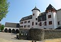
Mengerskirchen Castle, now town hall

Sauerborn near Probbach

Maienburg castle ruins near Winkels
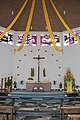
Interior view of the Maria Magdalena Church in Mengerskirchen


Economy and Infrastructure
education
In the municipality of Mengerskirchen there is a primary school as well as a secondary and secondary school. In addition, secondary schools in Weilburg and Limburg an der Lahn are visited.
Franz Leuninger School
The Franz Leuninger School is located in the Mengerskirchen district. This is the community's primary school . It is named after the resistance fighter against the Nazi regime, Franz Leuninger, who came from Mengerskirchen .
Westerwald School
In the district of Waldernbach is the Westerwaldschule, which opened on October 21, 1977, is a secondary and secondary school for the communities of Mengerskirchen, Merenberg , Waldbrunn (except Ellar ) and Beselich (district of Heckholzhausen ).

Leisure and sporting activities
Around the highest elevation in the area, the knot that rises on the edge of the municipality of Mengerskirchen, interested parties can devote themselves to cross-country skiing during the winter months. In summer the two reservoirs Seeweiher Mengerskirchen and Waldsee offer the opportunity to swim.
A campsite is operated at the Seeweiher Mengerskirchen swimming lake . There has been a weekend house settlement with 66 houses since 1978 . In Dillhausen and Probbach there are mineral water springs - called Sauerborn in the population . They are popular hiking destinations.
Facilities
- Mengerskirchen kindergarten
- Waldernbach kindergarten
- Kindergarten Winkels and Probbach
- Dillhausen kindergarten
- Mengerskirchen volunteer fire brigade , founded in 1898 (including fanfare since 1966 and youth fire brigade since October 1, 1994)
- Dillhausen volunteer fire brigade, founded in 1927 (including youth fire brigade since April 29, 1992)
- Voluntary fire brigade Probbach, founded in 1934 (including youth fire brigade since April 1, 1984)
- Waldernbach volunteer fire brigade, founded in 1925 (including youth fire brigade since July 1, 1972)
- Voluntary fire brigade Winkels, founded in 1928 (including wind band since 1953 and youth fire brigade since March 30, 1985)
traffic
Mengerskirchen is not directly connected to the trunk road network. The next connection points to the federal highway 49 are in the communities of Merenberg and Löhnberg (approx. 5 km away). The next connection points to the federal motorway 45 are in the city of Herborn (approx. 18 km). Since the closure of part of the Kerkerbach Railway between Mengerskirchen and Hintermeilingen in 1930, there has been no railway line. The distance to Frankfurt Airport is about 85 km away.
Personalities
- Franz Leuninger (1898–1945), Christian trade unionist and resistance fighter against the Nazi regime
- Ernst Leuninger (1933–2018), Catholic theologian, university professor and honorary canon
- Wolfgang Schlicht (* 1952), sports scientist and university professor
- Tobias Eckert (* 1980), politician (SPD), member of the Hessian state parliament since 2012
- Oliver Geis (* 1991), marksman
Web links
- Large community Mengerskirchen. Local history, sights, information. In: www.sehenswertes-in-mengerskirchen.de. Private website
- Mengerskirchen, Limburg-Weilburg district. Historical local dictionary for Hessen. In: Landesgeschichtliches Informationssystem Hessen (LAGIS).
- Literature about Mengerskirchen in the Hessian Bibliography
- Link catalog on Mengerskirchen at curlie.org (formerly DMOZ )
Individual evidence
- ↑ Hessian State Statistical Office: Population status on December 31, 2019 (districts and urban districts as well as municipalities, population figures based on the 2011 census) ( help ).
- ↑ Franz-Josef Sehr : Fire Department District Days around the turn of the century . In: Yearbook for the Limburg-Weilburg district 2000 . The district committee of the district of Limburg-Weilburg, Limburg-Weilburg 1999, ISBN 3-927006-29-7 , p. 187-189 .
- ↑ Amalgamation of the communities of Dillhausen, Mengerskirchen, Probbach, Waldernbach and Winkels in the Oberlahnkreis to form the community of "Mengerskirchen" (point 117a) on January 5, 1971 . In: The Hessian Minister of the Interior (ed.): State Gazette for the State of Hesse. 1971 No. 3 , p. 111 ( online at the information system of the Hessian state parliament [PDF; 5.5 MB ]).
- ↑ a b c Mengerskirchen, Limburg-Weilburg district. Historical local dictionary for Hessen. (As of May 14, 2018). In: Landesgeschichtliches Informationssystem Hessen (LAGIS).
- ^ Michael Rademacher: German administrative history from the unification of the empire in 1871 to the reunification in 1990. State of Hesse. (Online material for the dissertation, Osnabrück 2006).
- ^ Local elections 1972; Relevant population of the municipalities on August 4, 1972 . In: The Hessian Minister of the Interior (ed.): State Gazette for the State of Hesse. 1972 No. 33 , p. 1424 , point 1025 ( online at the information system of the Hessian state parliament [PDF; 5.9 MB ]).
- ↑ Local elections 1977; Relevant population figures for the municipalities as of December 15, 1976 . In: The Hessian Minister of the Interior (ed.): State Gazette for the State of Hesse. 1976 No. 52 , p. 2283 , point 1668 ( online at the information system of the Hessian state parliament [PDF; 10.3 MB ]).
- ^ Local elections 1985; Relevant population of the municipalities as of October 30, 1984 . In: The Hessian Minister of the Interior (ed.): State Gazette for the State of Hesse. 1984 No. 46 , p. 2175 , point 1104 ( online at the information system of the Hessian state parliament [PDF; 5.5 MB ]).
- ^ Local elections in 1989; Relevant population figures for the municipalities as of October 25, 1988 . In: The Hessian Minister of the Interior (ed.): State Gazette for the State of Hesse. 1988 No. 45 , p. 2426 , point 1049 ( online at the information system of the Hessian state parliament [PDF; 4.6 MB ]).
- ↑ local elections 1993; Relevant population of the municipalities as of October 21, 1992 . In: The Hessian Minister of the Interior (ed.): State Gazette for the State of Hesse. 1992 No. 44 , p. 2766 , point 935 ( online at the information system of the Hessian state parliament [PDF; 6.1 MB ]).
- ^ Community data sheet : Mengerskirchen. (PDF; 222 kB) In: Hessisches Gemeindelexikon. HA Hessen Agency GmbH
- ↑ The population of the Hessian communities on June 30, 2010. (PDF; 552 kB) Hessisches Statistisches Landesamt, p. 11 , archived from the original on February 7, 2018 ; accessed on March 20, 2018 .
- ^ Result of the municipal election on March 6, 2016. Hessian State Statistical Office, accessed in April 2016 .
- ^ Hessian State Statistical Office: Result of the municipal elections on March 27, 2011
- ^ Hessian State Statistical Office: Result of the municipal elections on March 26, 2006

Bad Camberg | Beselich | Breaking | Dornburg | Elbe Valley | Elz | Hadamar | Hünfelden | Limburg a. d. Lahn | Löhnberg | Mengerskirchen | Merenberg | Runkel | Selters (Taunus) | Villmar | Waldbrunn (Westerwald) | Weilburg | Weilmünster | Weinbach