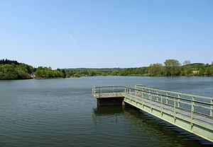
Seeweiher Mengerskirchen
| Seeweiher Mengerskirchen | ||
|---|---|---|

|
||
| View over the Seeweiher (Mengerskirchen) | ||
| Geographical location | Hesse | |
| Data | ||
| Coordinates | 50 ° 32 '53 " N , 8 ° 8' 58" E | |
|
|
||
| surface | 13 ha | |
| length | 939 m | |
The Seeweiher is located north of the district Waldersbach the community Mengerskirchen ( Limburg-Weilburg ) in Westerwald ( Hesse ) and impounds Vöhlerbach , a tributary of the Lahn -Nebenflusses Kallenbach . Its water surface is 13 hectares.
The lake pond was dammed in 1452, making it one of the oldest reservoirs in Hessen.
Freetime activities
There is a campsite on the shores of the bathing lake and, since 1978, a weekend house settlement with 66 houses. Every year, the Westerwald water work group organizes a water work test for Newfoundland and Landseer on the DLRG site at the Seeweiher.
Individual evidence
- ↑ The campsite. Camping site Seeweiher Mengerskirchen, accessed on June 15, 2019 .
Web links
- Hessian State Office for Environment and Geology: Seeweiher Mengerskirchen . In: Badeseen in Hessen, accessed on May 13, 2009
- Information about the lake pond
- Information on the Westerwald water working group
