
Runkel
| coat of arms | Germany map | |
|---|---|---|

|
Coordinates: 50 ° 24 ' N , 8 ° 9' E |
|
| Basic data | ||
| State : | Hesse | |
| Administrative region : | to water | |
| County : | Limburg-Weilburg | |
| Height : | 138 m above sea level NHN | |
| Area : | 43.72 km 2 | |
| Residents: | 9343 (Dec. 31, 2019) | |
| Population density : | 214 inhabitants per km 2 | |
| Postal code : | 65594 | |
| Primaries : | 06482, 06431 ( Dehrn ), 06471 ( Wirbelau ) |
|
| License plate : | LM, WEL | |
| Community key : | 06 5 33 013 | |
| LOCODE : | DE RUN | |
| City structure: | 9 districts | |
City administration address : |
Burgstrasse 4 65594 Runkel |
|
| Website : | ||
| Mayor : | Michel Kremer (independent) | |
| Location of the town of Runkel in the Limburg-Weilburg district | ||
  |
||

Runkel is a town in the Limburg-Weilburg district in central Hesse .
geography
location

Runkel is located in the Lahn valley on both sides of the river between the Westerwald and Taunus , in the east of the Limburg basin , around eight kilometers east of the district town of Limburg . Most of the built-up urban area and the old town lie on the left-hand lobe within a bend in the river that protrudes to the north. The right-wing northern parts of the city have emerged since the 19th century. In the northeast, the residential development has merged with that of the neighboring Schadeck district. Further to the west, the two places are separated by a steep slope. In the west, the Kerkerbach industrial area adjoins, which in turn passes directly to a new development area in the Steeden district . Here the two creeks Kerkerbach and Tiefenbach flow into the Lahn. In the 20th century, the city grew especially to the northeast and east.
The district of the core city consists of two unconnected parts. The larger one, in which the built-up urban area is located, forms a broad spur to the east and juts out to the west with a thin footbridge on both sides of the Lahn. In the west the district borders on Ennerich , in the northwest on Steeden, in the north and northeast on Schadeck, all of them districts. The core community of Villmar joins in the south-east and south, and the Limburg district of Lindenholzhausen in the south-west . The second part of the district comprises a large, closed forest area, extends in a south-west-north-east direction and is located a few kilometers northeast of the city. It borders clockwise from the west on Eschenau , Hofen , Schadeck and Arfurt , in the southeast on the Villmarer district Seelbach , in the northeast on the Runkel district Wirbelau and in the north on the Beselich district Schupbach .

The city itself is located directly on the banks of the Lahn and on the steep slopes north and south of the river. Most of the district extends over the plain south of the Lahn between 160 and 180 meters above sea level. The lowest point on the banks of the Lahn is around 110 meters high. The highest point of the separated part of the district in the northeast is around 255 meters. The area of the southern part of the district consists mainly of agricultural land, plus the wooded meadows of the Lahn and some side streams. Then there is the steep slope between Runkel and Schadeck, overgrown with bushes. The separated part of the district in the northeast is almost completely overgrown by mixed forest.
Neighboring communities
Runkel borders in the north on the municipality of Beselich and the city of Weilburg , in the east on the municipalities of Weinbach and Villmar , and in the south and west on the district town of Limburg.
City structure


The city consists of nine districts.
| district | Ew. 1910 |
Ew. 1961 |
Ew. 1970 |
Ew. 2005 |
Ew. 2008 |
Ew. 2019 |
Day of incorporation |
|---|---|---|---|---|---|---|---|
| Arfurt | 650 | 911 | 858 | 939 | 915 | 848 | December 31, 1970 |
| Dehrn | 1061 | 1871 | 1928 | 2295 | 2307 | 2198 | July 1, 1974 |
| Ennerich | 317 | 445 | 538 | 865 | 852 | 789 | 1st December 1970 |
| Eschenau | 214 | 285 | 265 | 320 | 273 | 270 | December 31, 1970 |
| Hofen | 292 | 373 | 392 | 435 | 440 | 410 | December 31, 1970 |
| Runkel | 1109 | 1687 | 1782 | 1655 | 1671 | 1706 | - |
| Schadeck | 502 | 650 | 715 | 1112 | 1079 | 1052 | 1st December 1970 |
| Steeden | 696 | 1223 | 1352 | 1550 | 1526 | 1373 | 1st December 1970 |
| Whirlwind | 516 | 615 | 669 | 803 | 803 | 792 | December 31, 1970 |
history

The city was first mentioned in a document in 1159 in a deed of mortgage in which a nobleman Siegfried von Runkel appears as a witness. Presumably this Siegfried was the builder of Runkel Castle . By 1230 at the latest, the castle had a chapel, which was the first church in Runkel. In 1288 the lordships of Runkel and Westerburg were separated after years of family disputes. The Lahn weir, which still exists today, was built in the 11th or 12th century to operate a mill. Construction of the Lahnbrücke began in 1440 and lasted until 1448 due to disputes between the Runkel and Westerburger lines.
In 1543, Runkel Castle hosted Philipp Melanchthon as a guest of Count Johann IV von Wied . The Reformation was introduced in 1568. In 1622 the family split again when Count Hermann II zu Wied drove his younger brother Philipp Ludwig out of the rule and from Runkel Castle. In 1634 the town and castle were largely destroyed by the troops of Count Isolani in the Thirty Years' War . In 1649 the residential buildings of the castle were rebuilt as a palace complex. In 1791 Friedrich Ludwig, the last of the Wied-Runkel line, received the dignity of prince. In 1796 street fighting broke out in Runkel when troops of the Landgrave of Hesse-Darmstadt drove occupying soldiers of revolutionary France from the city.
In 1806, the right-leaning part of the Runkel rule, and thus also the right-leaning part of the city of Runkel, fell to the Grand Duchy of Berg . After the Congress of Vienna , the Runkel office came to the Duchy of Nassau . In 1824 the Wied-Runkel line was extinguished with the death of Prince Friedrich Ludwig. With this, the rule and town of Runkel fell to Wied-Neuwied.
Viticulture is documented in Runkel from 1270 onwards. In 1929 the cultivation was given up because of the phylloxera infestation and a cold winter. Most recently the area under cultivation was 35 hectares. In 1860, the first Runkeler Sparkasse was founded under the name "Advance Association". There has been a central water supply in the city since 1914.
Mining was an important economic factor from the 18th century at the latest, the Georg-Joseph mine near Wirbelau was one of the largest ore mines in the Lahn region for 160 years.
The Catholics of the city of Runkel have been making a pilgrimage to the pilgrimage chapel Maria Hilf Beselich for many decades , where they declare their faith.
Territorial reform
In the course of the Hessian regional reform , the previously independent municipalities of Steeden, Ennerich and Schadeck merged on December 1, 1970 and Arfurt, Eschenau, Hofen and Wirbelau on December 31, 1970 with the city of Runkel, the municipality of Dehrn became a state law on July 1, 1974 incorporated .
The earliest mentioned current district is Ennerich; it is guaranteed in a document from 790.
Territorial history and administration
The following list gives an overview of the territories in which Runkel was located and the administrative units to which it was subordinate:
- before 1806: Holy Roman Empire , county (since 1791 principality) to Wied-Runkel , office or rule of Runkel
- 1806–1813: Grand Duchy of Berg , Department of Sieg , Canton of Runkel (from 1811 Canton of Hadamar)
- 1813–1815: Principality of Nassau-Orange , Runkel office
- from 1816: German Confederation , Duchy of Nassau , Office of Runkel
- from 1849: German Confederation, Duchy of Nassau, Limburg District Office
- from 1854: German Confederation, Duchy of Nassau, Office of Runkel
- from 1867: North German Confederation , Kingdom of Prussia , Province of Hessen-Nassau , Administrative Region of Wiesbaden , Oberlahnkreis
- from 1871: German Empire , Kingdom of Prussia, Province of Hessen-Nassau, administrative district of Wiesbaden, Oberlahnkreis
- from 1918: German Empire, Free State of Prussia , Province of Hessen-Nassau, Administrative Region of Wiesbaden, Oberlahnkreis
- from 1944: German Empire, Free State of Prussia, Nassau Province , Oberlahnkreis
- from 1945: American zone of occupation , Greater Hesse , Wiesbaden district, Oberlahn district
- from 1949: Federal Republic of Germany , State of Hesse , Wiesbaden district, Oberlahnkreis
- from 1968: Federal Republic of Germany, State of Hesse, administrative district Darmstadt , Oberlahnkreis
- from 1974: Federal Republic of Germany, State of Hesse, administrative district Darmstadt, district Limburg-Weilburg
- from 1981: Federal Republic of Germany, State of Hesse, Gießen district, Limburg-Weilburg district
population
Population development
| Runkel: Population from 1834 to 2015 | ||||
|---|---|---|---|---|
| year | Residents | |||
| 1834 | 968 | |||
| 1840 | 1.004 | |||
| 1846 | 1,096 | |||
| 1852 | 1,140 | |||
| 1858 | 1,127 | |||
| 1864 | 1,190 | |||
| 1871 | 1,135 | |||
| 1875 | 1,124 | |||
| 1885 | 1,142 | |||
| 1895 | 1,053 | |||
| 1905 | 1.108 | |||
| 1910 | 1.109 | |||
| 1925 | 1.101 | |||
| 1939 | 1,098 | |||
| 1946 | 1,721 | |||
| 1950 | 1,736 | |||
| 1956 | 1,688 | |||
| 1961 | 1,687 | |||
| 1967 | 1,807 | |||
| 1970 | 6,571 | |||
| 1972 | 6,635 | |||
| 1976 | 8,600 | |||
| 1984 | 8,656 | |||
| 1992 | 9.115 | |||
| 2000 | 9,700 | |||
| 2010 | 9,507 | |||
| 2015 | 9,600 | |||
| Data source: Historical municipality register for Hesse: The population of the municipalities from 1834 to 1967. Wiesbaden: Hessisches Statistisches Landesamt, 1968. Further sources:; 1972 :; 1976 :; 1984 :; 1992 :; 2000, 2015 :; 2010: From 1970 including the towns incorporated into Hesse as part of the regional reform . | ||||
Religious affiliation
Source: Historical local dictionary
| 1885: | 1018 Protestant (= 89.14%), 98 Catholic (= 8.58%), 25 Jewish (= 2.19%) residents and one other Christian |
| 1961: | 1178 Protestant (= 69.83%) and 482 Catholic (= 28.57%) residents |
politics
City Council
The local elections on March 6, 2016 produced the following results, compared to previous local elections:
| Parties and constituencies | % 2016 |
Seats 2016 |
% 2011 |
Seats 2011 |
% 2006 |
Seats 2006 |
% 2001 |
Seats 2001 |
||
|---|---|---|---|---|---|---|---|---|---|---|
| SPD | Social Democratic Party of Germany | 41.7 | 13 | 42.2 | 13 | 44.7 | 14th | 38.9 | 12 | |
| CDU | Christian Democratic Union of Germany | 33.3 | 10 | 34.8 | 11 | 42.4 | 13 | 42.5 | 13 | |
| BL | Citizen List Runkel | 20.8 | 7th | 17.6 | 5 | 12.9 | 4th | 14.2 | 5 | |
| GREEN | Alliance 90 / The Greens | 4.2 | 1 | 5.1 | 2 | - | - | 4.4 | 1 | |
| THE LEFT | The left | - | - | 0.3 | 0 | - | - | - | - | |
| total | 100.0 | 31 | 100.0 | 31 | 100.0 | 31 | 100.0 | 31 | ||
| Voter turnout in% | 53.1 | 49.3 | 45.1 | 55.8 | ||||||
mayor
The police officer Friedhelm Bender (* 1955) was elected mayor in 2007 and re-elected in 2013. On June 16, 2019, he lost the mayor's runoff election against his non-party challenger Michel Kremer, who received 63.28% of the vote and took office on September 1, 2019. Friedrich Buchsieb was mayor of Runkel from 1896 to 1900 .
Mayor of the core city
The mayor of the Runkel district is Eberhard Bremser (SPD).
Buildings


- The ruins of Runkel Castle from the 12th century, expanded in the 14th century, destroyed in 1634. Today it is owned by the zu Wied family.
- The half-timbered houses from the 17th and 18th centuries.
- The stone Lahn bridge from the 15th century.
- The castle Schadeck from the 13th century.
- The Bannmühle was built in 1270 by Runkel and Schadeck together upstream of the city wall. It has been privately owned since 1800, and since 1972 it is no longer operated as a mill, but with a turbine to generate electricity.
- The former watchtower of the city wall now bears the bells of the Protestant church. It was destroyed by fires in 1634 and 1700. the first bell was hung in 1725, the youngest in 1986.
- The building of the parish school , the first Runkel school, dates from 1543.
- The former rectory was built in 1664, later became private property and was the town hall during the Second World War.
- The Protestant church was built in 1641 on the site of the previous building built in 1511 and burned down in 1634.
- From 1802 a widow's seat was built for the mother of Prince Christian Ludwig. When she died the following year, only the basement was finished. Construction work was suspended until the city bought the property and erected a new school building there from 1821 to 1825, which initially also housed part of the municipal administration and a guard room.
- The Burgmannen seat of the Barons Schütz von Holzhausen was first mentioned in 1424. In 1651 the building was modernized. From 1718 it was owned by the Counts of Wied and until 1811 served as the official residence of the heads of their offices.
- Today's local pharmacy was built in 1681 as an apartment for a bailiff . In 1818 the timber-framed building came into the possession of the pharmacist.
- The building of the old Latin school dates back to 1711. After 1800 it was the town hall and until 1818 the farm pharmacy. Later the Gasthaus Zur Traube was located there .
- The city hall stands on the site of the former princely orange garden. From 1883 to 1887 the building was built by the Prussian provincial administration as a district court. The town hall has been there since 1966.
- The previous building of the district court housed a brewery and the Gasthaus Zum Adler shortly after 1900 .
- The fountain on Lahnuferstraße has been restored and consists of a very rare Lahn marble variety that has not been mined today.
- The former princely cattle yard with tithe barn stands on the palace square. It was built after the city was devastated in the Thirty Years War and expanded in the 19th century. Today the club house is located there.
- The old town hall stands on the site of the former office building, which Count Wilhelm IV of Runkel-Wied had built in 1596 and later passed on to his court doctor Dr. Ersfeld left. Ersfeld had the building rebuilt after the town fire in 1634, as did his son, who succeeded him in office after another fire in 1691. From 1787 to 1965 it was the city hall. Today it is privately owned.

Railway station on a photo from 1897, seen from the northeast

City, castle and bridge on a photo from 1885, seen from the north
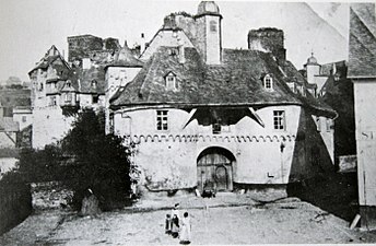
Castle gate on a photo from 1905


Economy and Infrastructure
traffic
Runkel has a stop at the Lahntalbahn , where only regional trains stop. The same applies to the Kerkerbach train station belonging to Runkel (with a siding to the Steedener lime works ) and the Arfurt stop. The city of Runkel is located in the area of the Rhein-Main-Verkehrsverbund . The renewal of the former Kerkerbach railway line to Steeden, which was carried out in 2009 with funds from the federal government and the state of Hessen, enables extensive lime transports by rail. The Kerkerbach industrial area can also be reached again for goods loading by rail if required.
The following state roads cross the town of Runkel: L3020 Limburg - Weilburg, L3022 Hünstelden (Kirberg) - Waldbrunn (Hausen), L3063 Dehrn - Usingen
Runkel is located on the Lahn Valley Cycle Path , which runs from the source of the Lahn in Siegerland to where it flows into the Rhine. The route between Gießen and Limburg is identical to that of the Hessian long-distance cycle route R7. In 2009 the Lahntal Cycle Path was awarded four out of five possible stars by the ADFC as a quality route for the second time .
The Lahn is a federal waterway from the Badenburg weir near Gießen (Lahn-km −11.075) to the mouth at Lahn-km 137.300. The Runkel lock, completed in 1842, bridges a height difference of 1.24 m and must be operated by the users themselves. From the port of Dehrn (Lahn-km 70.0) the fully congested route begins to the mouth at Lahnstein.
education
The Johann Christian Senckenberg School is located in Runkel. This is a primary school with an entrance level and an integrated comprehensive school. It was named after the German doctor and founder Johann Christian Senckenberg .
There are also elementary schools in Arfurt, Dehrn and Steeden.
Students from Runkel also attend high schools in Limburg and Weilburg.
Public facilities

- Protestant day care center "Pusteblume" Runkel
- Catholic kindergarten “St. Michael “Arfurt
- Catholic kindergarten “St. Nikolaus “Dehrn
- Kindergarten "Rainbow Land" Ennerich
- “Konfetti” day care center in Steeden
- Kindergarten "Wirbelwind" Wirbelau
- Voluntary fire brigade Runkel, founded in 1925 (since May 1, 1981 with youth fire brigade )
- Arfurt volunteer fire brigade, founded in 1901 (since March 1, 1999 with youth fire brigade)
- Dehrn volunteer fire brigade, founded in 1898 (since January 1, 1969 with youth fire brigade and since 2008 with brass orchestra)
- Ennerich voluntary fire brigade, founded in 1934 (with youth fire brigade since August 3, 1984)
- Eschenau volunteer fire brigade, founded in 1934 (with youth fire brigade since May 12, 2001)
- Hofen volunteer fire brigade, founded in 1934 (with youth fire brigade since August 13, 1992)
- Schadeck volunteer fire brigade, founded in 1933 (with youth fire brigade since June 26, 1993)
- Steeden volunteer fire brigade, founded in 1934 (with youth fire brigade since November 29, 1975)
- Voluntary fire brigade Wirbelau, founded in 1934 (since January 9, 1981 with youth fire brigade)
The public fire brigades Runkel and Schadeck merged on September 15, 2012. The fire brigade associations continue to exist in their previous form.
Personalities
- Johannes Lang (* around 1620), master tailor and opponent of the witch hunt
- Oscar Achenbach (1868–1935), portrait and landscape painter and graphic artist; lived and worked in Runkel after the First World War
- Rudolf Amend (1891–1968), member of the state assembly advising the constitution of Greater Hesse and mayor of Runkel 1945–1948 (CDU)
literature
- Magistrate of the City of Runkel (Ed.): Runkel 1159–2009. How it was - how it is . Runkel 2005.
- Literature about Runkel in the Hessian Bibliography
Web links
- Website of the city of Runkel
- 360 degree panorama of the city and Runkel Castle
- Runkel, Limburg-Weilburg district. Historical local dictionary for Hessen. In: Landesgeschichtliches Informationssystem Hessen (LAGIS).
- Information about the city of Runkel. In: Hessisches Gemeindelexikon. HA Hessen Agentur GmbH , 2016.
- Link catalog on the topic of Runkel at curlie.org (formerly DMOZ )
Individual evidence
- ↑ Hessian State Statistical Office: Population status on December 31, 2019 (districts and urban districts as well as municipalities, population figures based on the 2011 census) ( help ).
- ↑ Population of the city of Runkel on the website of the city of Runkel , accessed on March 22, 2020.
- ^ Franz-Josef Sehr : 250 years pilgrimage chapel Maria Hilf Beselich . In: Yearbook for the Limburg-Weilburg district 2017 . The district committee of the district of Limburg-Weilburg, Limburg-Weilburg 2016, ISBN 3-927006-54-8 , p. 137-141 .
- ↑ Amalgamation of the town of Runkel and the communities Ennerich Schadeck and Steeden in the Oberlahnkreis to form the town of "Runkel" on November 30, 1970 . In: The Hessian Minister of the Interior (Ed.): State Gazette for the State of Hesse. 1970 No. 50 , p. 2339 , item 2340 ( online at the information system of the Hessian state parliament [PDF; 4.8 MB ]).
- ↑ Amalgamation of municipalities to form the town of Runkel on January 25, 1971 . In: The Hessian Minister of the Interior (ed.): State Gazette for the State of Hesse. 1971 No. 4 , p. 139 , point 156 ( online at the information system of the Hessian state parliament [PDF; 6.3 MB ]).
- ↑ Law on the reorganization of the Limburg district and the Oberlahn district. (GVBl. II 330-25) of March 12, 1974 . In: The Hessian Minister of the Interior (ed.): Law and Ordinance Gazette for the State of Hesse . 1974 No. 5 , p. 101 , § 6 ( online at the information system of the Hessian state parliament [PDF; 809 kB ]).
- ^ Federal Statistical Office (ed.): Historical municipality directory for the Federal Republic of Germany. Name, border and key number changes in municipalities, counties and administrative districts from May 27, 1970 to December 31, 1982 . W. Kohlhammer, Stuttgart / Mainz 1983, ISBN 3-17-003263-1 , p. 372-373 .
- ↑ a b c Runkel, Limburg-Weilburg district. Historical local dictionary for Hessen. (As of May 24, 2018). In: Landesgeschichtliches Informationssystem Hessen (LAGIS).
- ^ Michael Rademacher: German administrative history from the unification of the empire in 1871 to the reunification in 1990. State of Hesse. (Online material for the dissertation, Osnabrück 2006).
- ^ Local elections 1972; Relevant population of the municipalities on August 4, 1972 . In: The Hessian Minister of the Interior (ed.): State Gazette for the State of Hesse. 1972 No. 33 , p. 1424 , point 1025 ( online at the information system of the Hessian state parliament [PDF; 5.9 MB ]).
- ↑ Local elections 1977; Relevant population figures for the municipalities as of December 15, 1976 . In: The Hessian Minister of the Interior (ed.): State Gazette for the State of Hesse. 1976 No. 52 , p. 2283 , point 1668 ( online at the information system of the Hessian state parliament [PDF; 10.3 MB ]).
- ^ Local elections 1985; Relevant population of the municipalities as of October 30, 1984 . In: The Hessian Minister of the Interior (ed.): State Gazette for the State of Hesse. 1984 No. 46 , p. 2175 , point 1104 ( online at the information system of the Hessian state parliament [PDF; 5.5 MB ]).
- ↑ local elections 1993; Relevant population of the municipalities as of October 21, 1992 . In: The Hessian Minister of the Interior (ed.): State Gazette for the State of Hesse. 1992 No. 44 , p. 2766 , point 935 ( online at the information system of the Hessian state parliament [PDF; 6.1 MB ]).
- ↑ Community data sheet : Runkel. (PDF; 222 kB) In: Hessisches Gemeindelexikon. HA Hessen Agency GmbH
- ↑ The population of the Hessian communities on June 30, 2010. (PDF; 552 kB) Hessisches Statistisches Landesamt, p. 11 , archived from the original on February 7, 2018 ; accessed on March 20, 2018 .
- ^ Result of the municipal election on March 6, 2016. Hessian State Statistical Office, accessed in April 2016 .
- ^ Hessian State Statistical Office: Result of the municipal elections on March 27, 2011
- ^ Hessian State Statistical Office: Result of the municipal elections on March 26, 2006
- ↑ Friedhelm Bender: The head full of ideas. In: online edition. Frankfurter Neue Presse, March 23, 2015, accessed December 19, 2017 .
- ↑ vote iT GmbH - votemanager: Mayoral election of the city of Runkel
- ↑ Committees. In: website. City of Runkel, accessed on August 12, 2020 .

Bad Camberg | Beselich | Breaking | Dornburg | Elbe Valley | Elz | Hadamar | Hünfelden | Limburg a. d. Lahn | Löhnberg | Mengerskirchen | Merenberg | Runkel | Selters (Taunus) | Villmar | Waldbrunn (Westerwald) | Weilburg | Weilmünster | Weinbach