
Dehrn
|
Dehrn
City of Runkel
|
|
|---|---|
 |
|
| Height : | 118 m above sea level NHN |
| Residents : | 2198 (Dec. 31, 2019) |
| Incorporation : | July 1, 1974 |
| Postal code : | 65594 |
| Area code : | 06431 |
Dehrn is a district of Runkel , located on the right bank of the Lahn in the central Hessian district of Limburg-Weilburg . Dehrn has around 2200 inhabitants, making it the largest district in Runkel.
Geography and geology


Dehrn is located in the Lahn valley in the Limburg basin at an altitude of 112 to 210 m above sea level. NHN. The terrain is characterized by the right Lahn valley, which slopes significantly at this point, while the left-hand Lahn area extends comparatively flat to the river. The houses of the village are located on this right-wing slope and in the valley of the Rolsbach, which is also clearly cut to the north. The remaining parts of the district are quite flat, either at a low level in the south, on the left of the Lahn or after the bank step in the north, 40 to 60 meters higher. The lowest point is where the Lahn leaves the southern edge of the district, at around 112 meters, at the boundary to Obertiefenbach in the "Cassel" corridor, 210 meters above sea level are reached. The average annual temperature is 8.5 ° C. The annual precipitation is 550 l / m².
The geological character is determined by deposits of loess clay . This hides the actual landscape-defining structure of the Paleozoic section of the Tertiary . This can be seen in the mass limestone range that runs through the western part of the district as Schlossberg, Kirschenberg and Fichtenberg. In addition, smaller occurrences of greywacke slate , Middle Devonian slate and scarf stone are to be noted. Quartz gravel can be found in the north of the district and in the so-called “Niederholz” area . To the south of the Lahn, ice-age deposits can be found as terrace gravel, gravel and sand. The best soils in the district are degraded steppe soils in the form of parabroun earths.
The river Lahn is characteristic of Dehrn . The place itself lies on the right-wing leaning on the north-westerly curve of a large Lahn loop bulging to the north, on whose north-east curve the neighboring village of Steeden lies. Pleasure boats from the Limburg Boat Club are moored in Dehrner Hafen. Earlier there were limestone , iron ore , alumina and coal loaded. Another body of water is the Rolsbach . The Rolsbach rises on the boundary to Ahlbach in the north. On the south side of the Lahn there are former gravel and clay pits that have been released from the wild vegetation.
The Dehrner district is roughly crescent-shaped, stretched in a north-south direction and bulging to the west. It borders in the north over a small stretch on Obertiefenbach and in the northeast on Niedertiefenbach , both districts of Beselich , in the east on Steeden and in the southeast on Ennerich , which also belong to the town of Runkel. The Limburg districts of Eschhofen , Dietkirchen , Offheim and Ahlbach connect from southwest to northwest .
vegetation
Interspersed in the agricultural areas are a large orchard meadow in “den Borngräben” and one on “the Cassel”. The forest is distributed over a thin, north-south-running strip on the western edge of the village, which widens significantly to the south, and in a part of a larger forest area in the southeast, on the opposite side of the Lahn as seen from the village. The forest on the western edge of the village is called "Niederholz". This little wood is the rest of the formerly large Dehrner forest, which stretched from Ahlbach over the ridge "Auf dem Cassel".
Land use and protected areas
The total size of the district is 528 hectares, of which 288 hectares are used as arable land, there are 83 hectares of grassland, 104 hectares of forest and 84 hectares is occupied by the place itself. Dehrn lies in the area of the Taunus landscape protection area . Also forest areas, the former gravel pits , "Wahls Tümpel", the former clay pit and former storage facility for household waste "Lüngen" are nature reserve . The area of the western forest side is protected area zone two of the Steeden and Obertiefenbach waterworks .
history

Already since the Neolithic , an estimated 5000 BC. BC, people live on the cheap Lahnfurt . Finds of bones, pottery shards and stone axes during the construction of the Church of St. Nicholas in 1923 suggest this. Also Frankish tombs of the 7th century AD have been found during excavation in Dehrn.
The place name was first mentioned in writing in 1197 in a lien. In this pledge agreement signed a "Frei von Dern" as a witness. Also around the year 1190, a tower that has only been preserved in ruins and what is now the right-hand part of the Burgmannenhaus, which is located below Dehrn Castle , must have been built. The Frei were probably also the builders of the castle, whose construction date cannot be precisely determined. However, the Frei were enfeoffed with the castle only by the Counts of Diez , who also owned the entire place. It only became part of the Frei von Dehrn estate after 1492.
Dehrn was the seat of the "Dehrner Central Court ". Because of its size and age, this cent was one of the most important in the county and lasted until the 18th century , but from the 14th to the 16th century with its seat in Niederhadamar . A mayor was first guaranteed for Dehrn in 1259, for the first time in 1336 a Heimberger, the head of a parish court. The tithe was collected in the "tithe barn", which today belongs to Hintergasse 1 and has been used as a farmer's barn in recent years. The barn has been owned by the Caspari family for decades.
After several pledges, Dehrn was transferred to the ascending House of Nassau in 1387 when the Diezer Count House died out . With the division into numerous side lines characteristic of the Nassau house, the Counts of Katzenelnbogen and the House of Eppstein received shares in the rulership of Dehrn through marriage and inheritance at the beginning of the 15th century, and the Landgraves of Hesse at the end of the century . In addition, Kurtrier was feudal lord of the House of Nassau and also raised claims on Dehrn. In 1607 the place belonged again completely to the county of Nassau-Hadamar , which was elevated to a principality in 1650. Despite the Reformation of the other places of the Dehrner Cent, Dehrn himself remained Catholic. After the death of the last Hadamar prince in 1711, rule over Dehrn changed several times between different lines of the House of Nassau, but was mostly assigned to the Hadamar office.
In 1737 the Frei von Dehrn died out in the male line. The castle fell to the Greiffenclau family, who converted it into a palace and sold it at the beginning of the 19th century. Since then, ownership has changed several times.
After belonging to the Grand Duchy of Berg in Napoleonic times, Dehrn passed into the ownership of the newly founded Duchy of Nassau in 1805 , which attached the place to the Limburg Office. A school building was erected in 1828 and demolished in 1971. The mining of Roteisenstein is documented for the first time in 1840, mining for brownstone in 1860 and later for phosphorite . In 1866, like all of Nassau, Dehrn became Prussian . The town hall was built in 1871 and is now used as a residential and commercial building. Two years later, the "Hubertusstift" emerged from the branch of the poor servants of Jesus Christ , founded in 1896 . The sister house was closed in 1965 and two years later it was converted into a secular old people's home.
A regular steamboat connection on the Lahn to Limburg existed from 1884 at the latest. From 1907 motorboats were used. In July 1949, the regular passenger boat connection to Limburg was discontinued after a bus connection went into operation at the beginning of the year.
In 1902 a steel road bridge over the Lahn was completed, in 1905 the place got running water and in 1909 it was connected to the power grid. The first sewers were built in 1933, but most of the buildings were not connected until 1957 to 1961. In 1921, the Catholic community was released from the parish Dietkirchen and the following year to Pfarrvikarie levied. In 1926 the church was completed. The Catholics of Dehrn have been making pilgrimages to the pilgrimage chapel Maria Hilf Beselich for many decades , where they announce their faith.
On March 26, 1945, the fleeing Wehrmacht blew up the steel bridge over the Lahn. In September 1948, the new building, the concrete structure that still exists today, was finished after two years of construction. In the second half of the 20th century, the place expanded through new development areas, especially to the north and east. In 1955 the sports field on the Lahn was laid out. The clay mining in the Dehrner Forest was stopped in 1963, the cargo ship traffic in the Dehrner Hafen in 1963. Both today's parish hall and the primary school were built in 1968 and 1969; kindergarten followed a year later. In 1972 an indoor swimming pool was built that is no longer in operation today.
On July 1, 1974, the community was in the course of administrative reform in Hesse by state law in the city Runkel incorporated .

Dehrn Castle

View into the courtyard

Former town hall


Place name
The origin of the place name Dehrn can be traced back to Celtic roots. The word dunum, Celtic for fortified hill, solid place, fortress , securing the ford , has been abolished in the course of time to Durn, Dern, Dehrn. The “h” in the name “Dehrn” was not created until a spelling reform in the middle of the 19th century.
In documents that have been received, Dehrn was mentioned under the following place names (the year it was mentioned in brackets):
- Derne, de (1190) [Losse, Burgen und Schlösser an der Lahn, p. 80]
- Dorn (1616) [copper engraved map of Nassau]
Local nobility
The Frey von Dern


The most famous noble family in the area today were the Frey (Frei) von Dern. The part of the name "free" indicates that they were one of the noble families. According to Friedrich Frei von Dehrn, who is known for stabbing the brother and heir of Count Gerhard von Diez at Dehrn Castle in 1367, the family sank into knighthood because Friedrich had married a noblewoman. In 1409 the house was first owned by Dehrn, a Count of Diezer.
A Heinrich Frio is historically tangible for the first time in 1190. Relatives in the area of Frankenberg (Eder) and in the Wetterau are proven. Representatives of the family rarely appear in foreign administrative and military services. Apparently the considerable property concentrated around Dehrn was largely sufficient for the economic survival of the family. However, it hardly achieved any supra-local political significance. In the case of free float, some of which extended into the Rheingau, it was presumably not a question of goods acquired on a planned basis, but rather “by chance” through inheritance. There are family ties to the houses of Reifenberg , Kronberg , Eltz and Schönborn , among others .
The Frei were closely connected with the Lubentiusstift in neighboring Dietkirchen, of which they were temporarily. The castle Dehrn , the Burgmannenhaus at its foot, Castle Crass in the Rheingau and the castle Hartenfels (ruin) in the Westerwald are preserved from the property today .
In the male line, the family died out in Eltville in 1737 with Franz Alexander Kasimir, court and government councilor of Fulda. As the last member of the family, his daughter Johanna Amalia Christina, wife of the Electorate of Mainz, Adolf Wilhelm Franz Freiherr von Greiffenclau zu Vollrads, died in 1794 .
The coat of arms of Frey von Dern showed three (2: 1) golden or silver sheaves in blue under a golden shield head .
Other noble families
The equally noble family von Dehrn with the sloping beam comes from the Kempenich family . Their branch based in Dorndorf had property in Dehrn by the beginning of the 13th century at the latest. In 1226 at the latest, parts of the von Dorndorf also called themselves von Dehrn. At the end of the 13th century, this family also sank into the knighthood and called themselves Ritz von Dehrn . An important representative of the family was Godefried Ritz von Dehrn, from 1330 until his death on February 24, 1345 Abbot of Jakobsberg Monastery near Mainz. The last member of the family died after 1414. Aside from Dehrn, the focus of ownership was in Dauborn, Dorndorf and Obertiefenbach.
The von Dehrn with the rose appear only from 1278 to 1332 and are related by marriage to the Ritz von Dehrn.
The Erlenbach called by Dehrn appear under different names, including von Altendiez, von Diez and von Tiefenbach. Her coat of arms showed two rings placed one below the other in a split shield. The family is first mentioned in 1285 with Peter von Altendiez. In 1311 the name "von Dehrn" is used for the first time. The last time a member of the family is mentioned is 1596. Members of the family used it as a cellar for the various bailiffs of Villmar . In addition to Dehrn, the focus of ownership was also Diez, Altendiez, Freiendie, Limburg, Obertiefenbach and Villmar.
Territorial history and administration
The following list gives an overview of the territories in which Dehrn was located and the administrative units to which it was subordinate:
- before 1711: Holy Roman Empire , Principality of Nassau-Hadamar , Hadamar Office
- 1717–1743: Holy Roman Empire, Principality of Nassau-Dillenburg , Hadamar Office
- 1743–1806: Holy Roman Empire, Counts of Nassau-Diez as part of the Principality of Nassau-Orange , Hadamar Office
- from 1806: Grand Duchy of Berg , Department of Sieg , Canton of Hadamar
- from 1816: German Confederation , Duchy of Nassau , Hadamar Office
- from 1849: German Confederation, Duchy of Nassau, Limburg District Office
- from 1854: German Confederation, Duchy of Nassau, Hadamar Office
- from 1867: North German Confederation , Kingdom of Prussia , Province of Hessen-Nassau , Administrative Region of Wiesbaden , Unterlahnkreis
- from 1871: German Empire , Kingdom of Prussia, Province of Hessen-Nassau, administrative district of Wiesbaden, Unterlahnkreis
- from 1886: German Empire, Kingdom of Prussia, Province of Hesse-Nassau, District of Wiesbaden, District of Limburg
- from 1918: German Empire, Free State of Prussia , Province of Hesse-Nassau, District of Wiesbaden, District of Limburg
- from 1944: German Empire, Free State of Prussia, Nassau Province , Limburg District
- from 1945: American zone of occupation , Greater Hesse , Wiesbaden district, Limburg district
- from 1949: Federal Republic of Germany , State of Hesse , Wiesbaden district, Limburg district
- from 1968: Federal Republic of Germany, State of Hesse, administrative district Darmstadt , district Limburg
- on July 1, 1974 Dehrn was incorporated as a district of the city of Runkel.
- from 1974: Federal Republic of Germany, State of Hesse, administrative district Darmstadt, district Limburg-Weilburg
- from 1981: Federal Republic of Germany, State of Hesse, Gießen district, Limburg-Weilburg district
Population development
| Dehrn: Population from 1834 to 1967 | ||||
|---|---|---|---|---|
| year | Residents | |||
| 1834 | 721 | |||
| 1840 | 751 | |||
| 1846 | 807 | |||
| 1852 | 916 | |||
| 1858 | 965 | |||
| 1864 | 1,049 | |||
| 1871 | 1,080 | |||
| 1875 | 972 | |||
| 1885 | 1,121 | |||
| 1895 | 1,057 | |||
| 1905 | 1,058 | |||
| 1910 | 1,061 | |||
| 1925 | 1,227 | |||
| 1939 | 1,236 | |||
| 1946 | 1,632 | |||
| 1950 | 1,944 | |||
| 1956 | 1,876 | |||
| 1961 | 1,871 | |||
| 1967 | 1,874 | |||
| Data source: Historical municipality register for Hesse: The population of the municipalities from 1834 to 1967. Wiesbaden: Hessisches Statistisches Landesamt, 1968. Other sources: - | ||||
Almost 2200 people live in Dehrn, the proportion of foreigners is 10.7 percent. The western districts of Runkel, which also includes Dehrn, recorded a population increase of 8.2% between 1991 and 1999 . However, development is stagnating in Dehrn, as there is hardly any free building land available. The city of Runkel has a negative commuting balance, 877 inbound commuters compared to 2,623 outbound commuters.
politics
The mayor is Bernd Polomski (list of citizens).
coat of arms
|
|
Blazon : "In blue three sheaves of silver (2: 1)."
The coat of arms was approved on November 21, 1967 by the Hessian Minister of the Interior. |
Culture and sights
Regular events
The highest festival in Dehrn is the "Dehrner Kirmes" ( parish fair ), which takes place annually on the second weekend in July and lasts from Friday to Monday. But also various street festivals and larger events of local associations, such as the strawberry festival, the Lahn barbecue day, the May buck days and the carnival are very popular.
Local specialities
The “Dehrner Broxel” is a post-Christmas dish in which the gingerbread left over from the festival is chopped up and mixed with plenty of grain, rock sugar and seltzer water until you get a spoonable soup .
Nickname
The citizens of Dehrner are popularly referred to as "Dehrner ravens".
societies
Dehrn has the male choir "Singer Association" with various choirs, the TuS 05 sports club , the Dehrn volunteer fire brigade (founded in 1898, with a youth fire brigade since January 1, 1969 and with its brass orchestra since 2008 ), a tennis club, a VdK local group, a fruit - and horticultural association and a Catholic women's community.
Buildings
Sights of the village are the Dehrn Castle and the associated but older former Hofmannenhaus, the "Pfalz". While the main structure dates back to the 12th century, most of the building was constructed around 1480. From 1998 to 2000 the “Pfalz” was extensively restored. The property can be entered through an archway. The walls of the basement are remarkably massive. They have a thickness of about three meters. It could have been an earlier checkpoint for the Lahn crossing. Until a few decades ago, there was also a tithe barn on the site.
The St. Nicholas Chapel as a former palace chapel and branch church of Dietkirch Lubentiusstift was the parish church of the village until 1926. It was built in the 13th century and first mentioned in a document in 1327. After the new St. Nicholas Church was built, the chapel was used as a kindergarten from 1930 to 1970. In 1974 the chapel was consecrated again. Only since the renovation from 2000 to 2002 have church services been held there again.
From 1923 to 1926 the Church of St. Nicholas was built in the baroque style. The three-arched Lahn bridge represents a transition from the Westerwald to the Taunus , the natural boundary of which is the Lahn .

Burgmannenhaus "Pfalz"
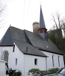
Nikolauskapelle

The Dehrner Church of St. Nikolaus


Natural monuments
There are two oaks near Dehrn Castle. A pedunculate oak with a chest height of 7.65 m (2014) and a pyramidal oak with a chest height of 6.29 m (2014).
Economy and Infrastructure
Economic development
The building structure shows a dichotomy: the old town center is juxtaposed with new building areas designated after 1945, with 45 percent of all residential buildings built before 1918. In the east of Dehrn along the road to Steeden , a large industrial area has developed, which merges into the area of the Steedener lime works. In 2005 the disused brick factory was demolished and the entire building was removed. The site is to be given a new use. In the meantime, several residential buildings and a Lidl market have been built on the site.
traffic
Dehrn is well connected to the road network thanks to the junction with the B49 / B54 . The long-distance cycle route R7 runs along the Lahn .
Public facilities
In Dehrn there is a kindergarten , a primary school , a village community center , a fire brigade and club house, a branch of the Runkel city administration, a church , two chapels , a cemetery as well as a pharmacy, a general practitioner and two dentists. Sports facilities include a soccer field, tennis courts and two children's playgrounds.
The Dehrn volunteer fire brigade , founded in 1898 (with a youth fire brigade since January 1, 1969), provides fire protection and general assistance.
Personalities
The best-known native Dehrner is probably Bernd Hölzenbein (* 1946), a former soccer player who learned to play soccer at the local TuS 05 Dehrn, won the soccer world championship in 1974 with the team of the then Federal Republic of Germany and for 13 years for Eintracht Frankfurt played in the Bundesliga . To this day, “Holz” is Eintracht's record scorer in the Bundesliga with 160 goals , and was temporarily its vice-president, sports advisor and chief scout .
literature
- Hellmuth Gensicke : State history of the Westerwald. 2., supplemented reprint of the edition from 1958. Publications of the Historical Commission for Nassau, No. 13. Published by the Historical Commission for Nassau together with the Landesarchivverwaltung Rheinland-Pfalz. Historical Commission for Nassau, Wiesbaden 1987, ISBN 3-922244-80-7
- Hellmuth Gensicke: On the history of the Nassau nobility: The von Dehrn . In: Association for Nassau antiquity and historical research (Hrsg.): Nassauische Annalen . tape 94 . Hessisches Hauptstaatsarchiv, Nassau 1983, p. 279-289 .
- Ernst Friedrich Keller: The tribulations of the Nassau people and the neighboring countries in the times of the Thirty Years' War, its heroes, statesmen and other famous contemporaries. A contribution to the inner history of that time, edited from archival and other sources. Perthes, Gotha 1854.
- Literature about Dehrn in the Hessian Bibliography
- Search for Dehrn in the archive portal-D of the German Digital Library
- Search for Dehrn in the SPK digital portal of the Prussian Cultural Heritage Foundation
Web links
- District Dehrn. In: Website of the city of Runkel.
- Dehrn on the Lahn. With village chronicle and pictures. In: www.Dehrn.net. Private website
- Dehrn, Limburg-Weilburg district. Historical local dictionary for Hessen. In: Landesgeschichtliches Informationssystem Hessen (LAGIS).
Individual evidence
- ↑ Numbers and facts. In: website. City of Runkel, accessed August 2020 .
- ^ Franz-Josef Sehr : 250 years pilgrimage chapel Maria Hilf Beselich . In: Yearbook for the Limburg-Weilburg district 2017 . The district committee of the district of Limburg-Weilburg, Limburg-Weilburg 2016, ISBN 3-927006-54-8 , p. 137-141 .
- ↑ Law on the reorganization of the Limburg district and the Oberlahn district. (GVBl. II 330-25) of March 12, 1974 . In: The Hessian Minister of the Interior (ed.): Law and Ordinance Gazette for the State of Hesse . 1974 No. 5 , p. 101 , § 6 ( online at the information system of the Hessian state parliament [PDF; 809 kB ]).
- ^ Federal Statistical Office (ed.): Historical municipality directory for the Federal Republic of Germany. Name, border and key number changes in municipalities, counties and administrative districts from May 27, 1970 to December 31, 1982 . W. Kohlhammer, Stuttgart / Mainz 1983, ISBN 3-17-003263-1 , p. 373 .
- ↑ a b Dehrn, Limburg-Weilburg district. Historical local dictionary for Hessen. (As of December 7, 2016). In: Landesgeschichtliches Informationssystem Hessen (LAGIS).
- ^ Johann Christian von Hellbach , Adels-Lexikon , Volume 1, p. 381
- ^ Michael Rademacher: German administrative history from the unification of the empire in 1871 to the reunification in 1990. State of Hesse. (Online material for the dissertation, Osnabrück 2006).
- ↑ Committees. In: website. City of Runkel, accessed on August 12, 2020 .
- ↑ Approval of a coat of arms of the municipality of Dehrn, district Limburg, administrative district Wiesbaden (item 1245) from November 21, 1967 . In: The Hessian Minister of the Interior (ed.): State Gazette for the State of Hesse. 1967 No. 50 , p. 1552 ( online at the information system of the Hessian state parliament [PDF; 4.0 MB ]).
- ↑ Information board at Dorfplatz Dehrn, text by Günther Seip, 2009
- ^ Entry in the directory of monumental oaks . Retrieved January 10, 2017
- ^ Entry in the directory of monumental oaks . Retrieved January 10, 2017