
Arfurt
|
Arfurt
City of Runkel
|
|
|---|---|
 |
|
| Height : | 161 m above sea level NHN |
| Area : | 5.49 km² |
| Residents : | 848 (Dec. 31, 2019) |
| Population density : | 154 inhabitants / km² |
| Incorporation : | December 31, 1970 |
| Postal code : | 65594 |
| Area code : | 06482 |
Arfurt is a district of Runkel with over 800 inhabitants. The place is located on the Lahn in the central Hessian district of Limburg-Weilburg .
Geographical location

Arfurt lies in the east of the Limburg Basin , above the north slope of the Lahn, which drops steeply at this point. The place is about three kilometers as the crow flies east of the core town of Runkel and about ten kilometers east of the district town of Limburg an der Lahn . The place breaks up into the old town center and a smaller new development area in the north, separated from it by the Linnebach and the surrounding broad grassland. The Lahntalbahn , which has a stop in Arfurt, runs along the banks of the Lahn south of the village . The Arfurt (Lahn) train station is about a kilometer outside of the village and stands out among the Lahntal train stations because of its corrugated iron construction.
The 5.5 square kilometer district borders on the neighboring Schadeck district to the west and on a larger forest area that belongs to the core town of Runkel but is separate from its district to the north. In the south, separated by the Lahn, is the neighboring market town of Villmar and in the east its district of Seelbach .

The place itself is about 160 meters above sea level. Immediately on its southeastern edge, the terrain drops steeply around 50 meters to the Lahn. In the west of the village, this transition is much gentler, so that the slope down to the banks of the Lahn is built up.
The district rises to the north over a long distance evenly up to 270 meters. The forked, north-south running valley of the Linnebach, which also divides the place in two halves, represents a slight incision in this elongated slope. The Tiefenbach on the western border of the district has formed a significantly steeper valley. The district consists mainly of agricultural land. The northern and western margins are covered by parts of a larger mixed forest area, which is largely in the area of the neighboring towns. Another, much smaller forest is located northeast of Arfurt.
history
Arfurt possibly already existed as a smaller farming settlement at the time of the first documentary mention of Villmar in 1053. The larger neighboring town is on the opposite bank of the Lahn and was of great importance for the development of Arfurt. Around a hundred years later, Arfurt (Arenvurt) is mentioned in a copy of the imperial deed of donation forged by Trier Benedictine monks . The Pope Eugene III. confirmed the imperial donation including Arfurt in 1148 on the occasion of a visit to the Trier Benedictine monks. The "Zultebach" settlement, also mentioned in the document, later fell into desolation and was probably located in the forest on what is now the western boundary of Arfurt.
The oldest house still in existence today was built in 1690.
In 1881 a large part of the village burned down.
On May 30, 1901, the Arfurt volunteer fire brigade was founded . In this way, she and other already existing volunteer fire brigades formed the Oberlahn extinguishing district in the fire brigade association for the Wiesbaden administrative region , within which she entered the district assembly in Obertiefenbach on September 3, 1906, with a strength of 34 members.
In the First World War 29 Arfurter died, in the Second World War 57. In September 1944, a residential building burned down after being hit by an incendiary bomb .
In 1931 the first kindergarten in Arfur started its work. In 1957 a new school building was built, and in 1964 the multi-purpose hall. Until the 1960s there was a ferry service over the Lahn to Villmar.
As part of the regional reform in Hesse , Arfurt and other communities voluntarily merged with the city of Runkel on December 31, 1970. This made Arfurt a district of Runkel.

The oldest surviving house, built in 1690
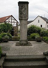
Cenotaph for those who fell in the world wars
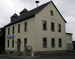
Former town hall


Territorial history and administration
The following list gives an overview of the territories in which Arfurt was located and the administrative units to which it was subordinate:
- before 1803: Holy Roman Empire , Electorate Trier , Lower Archbishopric, Limburg Office , Villmar Court (St. Matthias Abbey near Trier)
- from 1803: Holy Roman Empire, Principality of Nassau-Usingen (through Reichsdeputationshauptschluss ), Limburg Office
- from 1806: Duchy of Nassau , Limburg Office
- from 1816: German Confederation , Duchy of Nassau , Office of Runkel
- from 1849: German Confederation, Duchy of Nassau, Limburg District Office
- from 1854: German Confederation, Duchy of Nassau, Office of Runkel
- from 1867: North German Confederation , Kingdom of Prussia , Province of Hessen-Nassau , Administrative Region of Wiesbaden , Oberlahnkreis
- from 1871: German Empire , Kingdom of Prussia, Province of Hessen-Nassau, administrative district of Wiesbaden, Oberlahnkreis
- from 1918: German Empire, Free State of Prussia , Province of Hessen-Nassau, Administrative Region of Wiesbaden, Oberlahnkreis
- from 1944: German Empire, Free State of Prussia, Nassau Province , Oberlahnkreis
- from 1945: American zone of occupation , Greater Hesse , Wiesbaden district, Oberlahn district
- from 1949: Federal Republic of Germany , State of Hesse , Wiesbaden district, Oberlahnkreis
- from 1968: Federal Republic of Germany, State of Hesse, administrative district Darmstadt , Oberlahnkreis
- On December 1, 1970, Arfurt was incorporated as a district of the city of Runkel.
- from 1974: Federal Republic of Germany, State of Hesse, administrative district Darmstadt, district Limburg-Weilburg
- from 1981: Federal Republic of Germany, State of Hesse, Gießen district, Limburg-Weilburg district
History of religion
By 1148 at the latest, the place had a chapel on an elevation on the banks of the Lahn. In 1652 it was consecrated to Saint Lambert of Liège . Until 1715 Arfurt was assigned to the parish of Villmar. The chapel became the seat of its own parish. In 1828 the current church, still consecrated to St. Lambertus , was completed. The old chapel had become dilapidated and was demolished five years later. The old train station at the location of the chapel remained in use until 1855.
In 1920 a sister house was set up for the Pallottine Sisters who lived and worked here until 1997.
Arfurt, together with Villmar, is a largely Catholic enclave, surrounded by predominantly Protestant villages (Seelbach, Runkel, Aumenau). The refugees from the Sudetenland who were admitted to Arfurt after the Second World War were probably all Catholics. The population was 925 in 1960, of which more than 900 were Catholics.
In 1815 a cemetery for the Jewish community in Villmar was established near Arfurt. Jews probably never lived in Arfurt itself. The Catholics of Arfurt have been making pilgrimages to the Maria Hilf Beselich pilgrimage chapel for many decades , where they proclaim their faith.
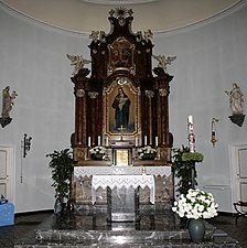
Altar of the parish church

Parish Church of St. Lambertus, apse side


Economic history
In Arfurt, wine was grown on the south-facing slopes of the Lahn valley well into the 19th century. There you can still find decaying wall remains from the slope fortifications of the earlier vineyards.
In addition, gray-colored marble was also mined in Arfurt until the 1960s. The stone can still be found processed in the parish churches in Arfurt, Villmar and in the St. Matthias Abbey of the Benedictine monastery of the same name in Trier.
In 1830 a paper mill started operations on the Linnebach. After several changes of ownership, it stopped working in 1879.
Around 1850, the chemist Fritz Muck, a student of Justus Liebig , ran a paint factory in Arfurt that sold its products throughout Germany and abroad.
population
Population development
| Arfurt: Population from 1834 to 1970 | ||||
|---|---|---|---|---|
| year | Residents | |||
| 1834 | 642 | |||
| 1840 | 697 | |||
| 1846 | 770 | |||
| 1852 | 807 | |||
| 1858 | 799 | |||
| 1864 | 850 | |||
| 1871 | 820 | |||
| 1875 | 805 | |||
| 1885 | 803 | |||
| 1895 | 715 | |||
| 1905 | 645 | |||
| 1910 | 650 | |||
| 1925 | 718 | |||
| 1939 | 654 | |||
| 1946 | 972 | |||
| 1950 | 943 | |||
| 1956 | 897 | |||
| 1961 | 911 | |||
| 1967 | 927 | |||
| 1970 | 858 | |||
| Data source: Historical municipality register for Hesse: The population of the municipalities from 1834 to 1967. Wiesbaden: Hessisches Statistisches Landesamt, 1968. Other sources: | ||||
Religious affiliation
Source: Historical local dictionary
| • 1885: | 7 Protestant, 796 Catholic residents |
| • 1961: | 39 Protestant, 868 Roman Catholic residents |
politics
The mayor is Cornel Fuchs (CDU).
societies
Arfurt has a sports club, since 1901 the Arfurt volunteer fire brigade (since March 1, 1999 with its youth fire brigade ), the church choir “St. Lambertus ”, a dance sport club“ TSV Arfurt ”, the choral society“ Linnebachtiroler ”, a wind choir, a comradeship club, a local group of the Catholic women's community and the Lambertusbrüder eV
Infrastructure
The Arfurt volunteer fire brigade , founded in 1901 (since March 1, 1999 with the youth fire brigade), provides fire protection and general help.
Web links
- District of Arfurt. In: Website of the city of Runkel.
- Arfurt, Limburg-Weilburg district. Historical local dictionary for Hessen. In: Landesgeschichtliches Informationssystem Hessen (LAGIS).
- Literature about Arfurt in the Hessian Bibliography
Individual evidence
- ↑ a b c d Arfurt, Limburg-Weilburg district. Historical local dictionary for Hessen. (As of March 23, 2018). In: Landesgeschichtliches Informationssystem Hessen (LAGIS).
- ↑ Numbers and facts. In: website. City of Runkel, accessed August 2020 .
- ↑ P. Johannes Hau OSB: Villmar manor / bailiwick / parish . Limburg printing house, Limburg / Lahn 1936
- ↑ Franz-Josef Sehr : Fire Department District Days around the turn of the century . In: Yearbook for the Limburg-Weilburg district 2000 . The district committee of the district of Limburg-Weilburg, Limburg-Weilburg 1999, ISBN 3-927006-29-7 , p. 187-189 .
- ↑ Amalgamation of municipalities to form the town of Runkel on January 25, 1971 . In: The Hessian Minister of the Interior (ed.): State Gazette for the State of Hesse. 1971 No. 4 , p. 139 , point 156 ( online at the information system of the Hessian state parliament [PDF; 6.3 MB ]).
- ^ Federal Statistical Office (ed.): Historical municipality directory for the Federal Republic of Germany. Name, border and key number changes in municipalities, counties and administrative districts from May 27, 1970 to December 31, 1982 . W. Kohlhammer, Stuttgart / Mainz 1983, ISBN 3-17-003263-1 , p. 372 .
- ^ Michael Rademacher: German administrative history from the unification of the empire in 1871 to the reunification in 1990. State of Hesse. (Online material for the dissertation, Osnabrück 2006).
- ^ Franz-Josef Sehr : 250 years pilgrimage chapel Maria Hilf Beselich . In: Yearbook for the Limburg-Weilburg district 2017 . The district committee of the district of Limburg-Weilburg, Limburg-Weilburg 2016, ISBN 3-927006-54-8 , p. 137-141 .
- ↑ Committees. In: website. City of Runkel, accessed on August 12, 2020 .