
Schupbach
|
Schupbach
Beselich municipality
|
|
|---|---|
 |
|
| Height : | 187 m above sea level NHN |
| Area : | 8.1 km² |
| Residents : | 1094 (Dec. 31, 2019) |
| Population density : | 135 inhabitants / km² |
| Incorporation : | December 31, 1970 |
| Postal code : | 65614 |
| Area code : | 06484 |
Schupbach is a district of the municipality of Beselich in the central Hessian district of Limburg-Weilburg and has around 1100 inhabitants.
geography
location
Schupbach is located on the northeastern edge of the Limburg basin , on the edge of the Lahn valley and on the southeast slope of the Westerwald . The village is nestled between Mörsberg, Hengen, the Beselicher Kopf (296 m) and in the valley of the Kerkerbach in the center of the Limburg-Weilburg district. The place is located about three kilometers east of the central town of Obertiefenbach and about ten kilometers northeast of the district town of Limburg an der Lahn .
The place is traversed by the Brandbach from northwest to southeast. The settlement itself is around 200 meters above sea level. The terrain rises gently to the west to up to 261 meters. There are hardly any differences in altitude to the south. The lowest point is southeast of the town at around 190 meters. To the north and east, Schupbach is followed by a steep step in the terrain, on which the ground level quickly rises to up to 263 meters. The highest point is reached in the west of the district near the Beselicher head with 294 meters. Agriculturally used land extends around the place, which in the south connects to a strip of agricultural land that extends to the Lahn. At the other boundaries of the district, the place is largely surrounded by mixed forest.
geology
The landscape is characterized by limestone and clay deposits . Limestone mining around Schupbach has a long history and its varieties were known under the supraregional generic term Lahn marble .
Neighboring places
In the north Heckholzhausen , in the east Gaudernbach and Wirbelau , in the south Eschenau and Niedertiefenbach , in the west Obertiefenbach . Up until the late Middle Ages, there was also a small town called “ Schuy ” between Schupbach and Obertiefenbach.
history
The place Schupbach and its own church were first mentioned in 1276 in a document from the Beselich monastery . For the 13th century, a noble family with the name "von Schupbach" is documented, whose coat of arms is still used today as the local coat of arms. A central court with Schupbach as its seat must have emerged by the 14th century at the latest . The place of justice was possibly the large linden tree in the churchyard. In 1366 this area of jurisdiction was initially transferred as a pledge from the County of Diez to the Lords of Runkel. Ten years later the pledge was converted into a hereditary fief. For 1495 Wirbelau , Falkenbach , Gaudernbach , Heckholzhausen, Eschenau and Obertiefenbach have been handed down as belonging to the center of Schupbach.
In 1565 the Reformation was introduced in Schupbach, initially according to the Lutheran , from 1587 according to the Reformed creed. In 1590 there was a school in Schupbach - unusually early for the region. A new schoolhouse was built in 1844 and demolished in 1980. The new school building from 1960 is now privately owned.
.jpg)
Marble mining must have started around 1600. During the Thirty Years' War the place was plundered and devastated by Croatians in 1634 and by Imperial Bavarian troops in 1646. In 1648 there were only twelve houses left. In 1799 a "robber congress" took place in Schupbach. The meeting was favored by the location of the place at the meeting point of several rulership borders, which made it possible to flee from criminal prosecution quickly.
In the first half of the 19th century, the six communities Obertiefenbach, Heckholzhausen, Gaudernbach, Wirbelau, Eschenau and Schupbach formed a fire fighting district. When a fire broke out, certain residents with four harnessed horses had to fetch the fire engine stationed in Schupbach immediately . From the year 1882 there is a report of a big fire on October 18 at the farmers Würz and Weidemann in Schupbach, which killed two barns and which also included the Obertiefenbach volunteer fire brigade , which was founded two years earlier, with its horse-drawn pressure and suction syringe advanced.
In 1806, Schupbach was appointed a municipality in the Duchy of Berg . In 1816 it was incorporated into the newly created Duchy of Nassau , and in 1866 into Prussia . In 1888 the place received a railway connection through the Kerkerbach Railway , which was shut down in 1960.
Territorial reform
The community of Schupbach merged on December 31, 1970 as part of the regional reform in Hesse with the previously independent communities of Heckholzhausen , Obertiefenbach and Niedertiefenbach (all in the former Oberlahnkreis ) to form the community of Beselich . It was named after the Beselich monastery . Local districts according to the Hessian municipal code were not established.
Economic history

Until the 1970s, limestone , marble and clay were mined and processed in Schupbach . Schupbach black marble , first mentioned in 1622, was used in the Empire State Building in New York, Schupbach white was used in Trier Cathedral , Famosa in Würzburg Cathedral , in the Hermitage in St. Petersburg and in the Moscow Metro . Gold vein , coral rock and Wiedischrosa were further names for types of marble quarried in Schupbach. The stone mason brothers Jacob and Theobaldus Weidemann, who immigrated from Winterthur in 1675, laid the foundation for the spread of Schupbacher marble .
In 1863, the “advance payment association” was established, which still exists today as “Volksbank Schupbach” and thus as one of the smallest Volksbanks in Germany.
Around 200 hectares of the municipal area consist of forest. The Schupbacher dairy , which was operated until the 1980s, had supra-local importance .
Territorial history and administration
The following list gives an overview of the territories in which Schupbach was located and the administrative units to which it was subordinate:
- before 1806: Holy Roman Empire , county (since 1791 principality) to Wied-Runkel , office or rule of Runkel
- 1806–1813: Grand Duchy of Berg , Department of Sieg , Canton of Runkel (from 1811 Canton of Hadamar)
- 1813–1815: Principality of Nassau-Orange , Runkel office
- from 1816: German Confederation , Duchy of Nassau , Office of Runkel
- from 1849: German Confederation, Duchy of Nassau, Limburg District Office
- from 1854: German Confederation, Duchy of Nassau, Office of Runkel
- from 1867: North German Confederation , Kingdom of Prussia , Province of Hessen-Nassau , Administrative Region of Wiesbaden , Oberlahnkreis
- from 1871: German Empire , Kingdom of Prussia, Province of Hessen-Nassau, administrative district of Wiesbaden, Oberlahnkreis
- from 1918: German Empire, Free State of Prussia , Province of Hessen-Nassau, Administrative Region of Wiesbaden, Oberlahnkreis
- from 1944: German Empire, Free State of Prussia, Nassau Province , Oberlahnkreis
- from 1945: American zone of occupation , Greater Hesse , Wiesbaden district, Oberlahn district
- from 1949: Federal Republic of Germany , State of Hesse , Wiesbaden district, Oberlahnkreis
- from 1968: Federal Republic of Germany, State of Hesse, administrative district Darmstadt , Oberlahnkreis
- on December 31, 1970 Schupbach was incorporated as a district of the municipality Beselich.
- from 1974: Federal Republic of Germany, State of Hesse, administrative district Darmstadt, district Limburg-Weilburg
- from 1981: Federal Republic of Germany, State of Hesse, Gießen district, Limburg-Weilburg district
Population development
The population peaked in 2002 with 1208 inhabitants and has since declined slightly.
| Schupbach: Population from 1834 to 2019 | ||||
|---|---|---|---|---|
| year | Residents | |||
| 1834 | 616 | |||
| 1840 | 659 | |||
| 1846 | 712 | |||
| 1852 | 777 | |||
| 1858 | 797 | |||
| 1864 | 900 | |||
| 1871 | 891 | |||
| 1875 | 827 | |||
| 1885 | 877 | |||
| 1895 | 782 | |||
| 1905 | 854 | |||
| 1910 | 850 | |||
| 1925 | 854 | |||
| 1939 | 781 | |||
| 1946 | 1,267 | |||
| 1950 | 1,169 | |||
| 1956 | 1,339 | |||
| 1961 | 1,148 | |||
| 1967 | 1,146 | |||
| 1970 | 1,091 | |||
| 1980 | ? | |||
| 1990 | ? | |||
| 2000 | 1,198 | |||
| 2006 | 1,145 | |||
| 2010 | 1,128 | |||
| 2011 | 1,122 | |||
| 2015 | 1,114 | |||
| 2019 | 1,094 | |||
| Data source: Historical municipality register for Hesse: The population of the municipalities from 1834 to 1967. Wiesbaden: Hessisches Statistisches Landesamt, 1968. Further sources:; 2011 census | ||||
Religious affiliation
Source: Historical local dictionary
| • 1885: | 811 Protestant (= 92.47%), 21 Catholic (= 2.39%), 45 Jewish (= 5.13%) residents |
| • 1961: | 950 Protestant (= 82.75%), 188 Catholic (= 16.38%) residents |
Culture and sights
societies
The oldest club in town is the singing choir "Unity". It originated in 1854 as a men's church choir. In 1973 he joined forces with the women's choir founded ten years earlier to form what is now the association. The sports club TuS Schupbach, founded in 1898, was joined by the former soccer club VfR 1920 and the handball team that was formed in 1928 shortly after the Second World War. Other associations are the Schupbach volunteer fire brigade, founded in 1925 (with its youth fire brigade since January 1, 1985 and with its children's fire brigade since March 7, 2020 ), the Kerkerbachtal poultry breeding association, founded in 1958, table tennis club 1975, carnival club Schupbach 2001 and pony and equestrian enthusiasts Weidenhof. In February 2010 the Friends of the Former Synagogue Schupbach eV was founded
Buildings

"Steam mill"
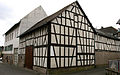
Hofanlage Eckerstraße
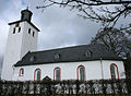
Evangelical parish church

Former synagogue


Former steam mill
In the economic development history of the region there was an early industrial building, which with its gable projection and the grouping of windows uses forms of traditional rulership architecture and thus emphasizes the importance of the manufacturer. The masonry consists of local quarry stones processed as a bosswork . Cornice edges , window arches and window sills are made of red brickwork that contrasts with the gray wall . Small tie-rod washers indicate the stretch ceiling construction.
Hofanlage Eckerstraße
Extensive, manorial courtyard between alleys, Mittelstrasse and Eckerstrasse. The three-storey house with an attached gateway axis is a plastered quarry stone building, built around 1460. The barns and stables are half-timbered buildings at the same time, some using older masonry. Determining the town center as a large farm complex from the 19th century.
Evangelical parish church
The church is a free building in the center of the village. The current, mostly newer terrace wall still indicates the raised old churchyard . There are several round-arched, baroque tombstones at the entrance portal. The high defense tower from the 11th century has barrel vaults on the two basement floors and a small, classicist lantern . The core of the nave is also Romanesque, was extended in 1696 and closed on three sides. The building has a simple wooden barrel ceiling. The one-sided gallery, pulpit and marble canteen were created around 1700 . The organ from 1816 was made by Johann Georg Bürgy from Gießen . The expressive folk paintings were created in 1936.
Former synagogue
In 1816 the first Jewish school was built in the village, which was consecrated as a synagogue in 1877 after being largely rebuilt. The Jewish community with its branches in Obertiefenbach, Heckholzhausen, Gaudernbach and Wirbelau had around 180 members at that time. In the larger wing there was the synagogue hall above and the schoolroom below (until 1904). The side and entrance building included stairs, gallery and bathroom. The ceiling of the prayer room is still in its original state. Golden stars are painted on a blue background. The women's gallery and the mikvah , the ritual immersion bath, are also still there. Besides the Hadamar synagogue, it is the only one in the Limburg-Weilburg district that was built and has been preserved as such.
Facilities and recreational opportunities

In Schupbach there is a municipal day-care center in the Bitz.
The Beselich-Schupbach volunteer fire brigade, founded in 1925, provides defensive fire protection and general assistance. On January 1, 1985, it was supplemented by the youth fire brigade.
For events which is participatory in Bitz available. The residents have the opportunity to use the sports field on the outskirts towards Heckholzhausen. In addition, there is a playground at the community center in Schupbach and several hiking trails in the woods and fields.
Personalities
- Andreas Jung (* 1960), German actor
Web links
- Districts. In: website. Beselich municipality
- Schupbach, Limburg-Weilburg district. Historical local dictionary for Hessen. In: Landesgeschichtliches Informationssystem Hessen (LAGIS).
- Literature about Schupbach in the Hessian Bibliography
Individual evidence
- ↑ a b c d Schupbach, Limburg-Weilburg district. Historical local dictionary for Hessen. (As of October 16, 2018). In: Landesgeschichtliches Informationssystem Hessen (LAGIS).
- ↑ a b c facts and figures . In: Internet presence. Municipality of Beselich, accessed on July 29, 2020 .
- ^ Franz-Josef Sehr : The fire extinguishing system in Obertiefenbach from earlier times . In: Yearbook for the Limburg-Weilburg district 1994 . The district committee of the Limburg-Weilburg district, Limburg-Weilburg 1993, p. 151-153 .
- ↑ Franz-Josef Sehr : The founding years of the volunteer fire brigade Obertiefenbach . In: Yearbook for the Limburg-Weilburg district 1995 . The district committee of the district of Limburg-Weilburg, Limburg-Weilburg 1994, p. 170-171 .
- ↑ Amalgamation of municipalities to form the municipality "Beselich", Oberlahnkreis on January 6, 1971 . In: The Hessian Minister of the Interior (ed.): State Gazette for the State of Hesse. 1971 No. 4 , p. 141 , point 169 ( online at the information system of the Hessian state parliament [PDF; 6.3 MB ]).
- ^ Federal Statistical Office (ed.): Historical municipality directory for the Federal Republic of Germany. Name, border and key number changes in municipalities, counties and administrative districts from May 27, 1970 to December 31, 1982 . W. Kohlhammer, Stuttgart / Mainz 1983, ISBN 3-17-003263-1 , p. 373 .
- ^ Michael Rademacher: German administrative history from the unification of the empire in 1871 to the reunification in 1990. State of Hesse. (Online material for the dissertation, Osnabrück 2006).
- ↑ Selected data on population and households on May 9, 2011 in the Hessian municipalities and parts of the municipality. (PDF; 1 MB) In: 2011 Census . Hessian State Statistical Office