Kerkerbach
| Kerkerbach | ||
|
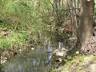
The Kerkerbach between Lahr and Heckholzhausen |
||
| Data | ||
| Water code | DE : 25872 | |
| location |
Westerwald
|
|
| River system | Rhine | |
| Drain over | Lahn → Rhine → North Sea | |
| source | in the southern Oberwesterwald from several sources near Fussingen and Lahr 50 ° 31 ′ 3 ″ N , 8 ° 6 ′ 34 ″ E |
|
| Source height | approx. 312 m above sea level NHN | |
| muzzle | in the Runkel district of the same name in the Lahn coordinates: 50 ° 24 '23 " N , 8 ° 7' 32" E 50 ° 24 '23 " N , 8 ° 7' 32" E |
|
| Mouth height | approx. 124 m above sea level NHN | |
| Height difference | approx. 188 m | |
| Bottom slope | approx. 9.1 ‰ | |
| length | 20.7 km | |
| Catchment area | 70.23 km² | |
| Drain |
MNQ MQ |
40 l / s 564 l / s |
The Kerkerbach is the right-hand, 20.7 km long tributary of the Lahn in the Limburg-Weilburg district in Hesse , Germany . Its catchment area is 70.23 km².
Surname
The name of the dungeon stream is probably derived from the sources in the Lahr corridor "Alte Keller", the former village of Oberlahr.
There are other more extensive derivations for the origin of the name. In an article about the Finstermühle near Schupbach, Willi Schmittel and Johannes Laubach explain the origin of the Bach name as follows:
“Kerkerbach is the name of the water and the valley has the appropriate name. But dungeon comes from the Celtic language and means "dark", "wet", "swampy". And a linguistic association can still be made in Middle High German. Here the term "dark" (vinestre) was still used for prison or dungeon. "
Christian Daniel Vogel also names the brook "Hüttenbach" and "Fensterbach".
geography
course

The Kerkerbach rises in the southern Oberwesterwald from several sources near Fussingen and Lahr. As meadows north of Lahr, parts of the headwaters form a fauna-flora-habitat protection area . The first major tributary is the Hintermeilinger raft , which flows into the Kerkerbach near the hammer mill . Between Schlagmühle and Heckholzhausen the stream flows through a narrow cut. Its lower course south of Heckholzhausen near Schupbach , Eschenau, Hofen, Steeden forms the natural border between the fertile Limburg basin and the plateaus of the Weilburg Lahn valley area . Correspondingly, the flatter western valley slopes, accompanied by fields, differ from the steep, sometimes even rocky and wooded eastern valley side. The Kerkerbach flows into the Lahn near the Runkel industrial park of the same name .
Tributaries
- Elzbach [GKZ 25872192] ( left ), 0.8 km
- Feuerbach [GKZ 25872194] ( left ), 0.9 km
- Hünsbach [GKZ 25872196] ( right ), 1.2 km
- Hintermeilinger Floß ( right ), 4.1 km
- Idersbach ( right ), 0.6 km
- Allendorfer Bach ( left ), 4.5 km
- Gaudernbach ( Dernbach ) ( left ), 4.2 km
- Hasselbach [GKZ 2587272] ( left ), 1.7 km
- Brandbach ( Schupbach ) ( right ), 5.1 km
- Christbach ( right ), 0.5 km
Kerkerbachbahn
The Kerkerbach gave its name to the 35 km long Kerkerbach Railway . This historic railway line was built between 1884 and 1888. It connected the places Mengerskirchen , Waldernbach , Fussingen , Lahr , Hintermeilingen , Heckholzhausen , Schupbach, Christianshütte, Eschenau, Hofen, Schadeck and Kerkerbach with the Kerkerbach train station of the Kerkerbachbahn AG and the Deutsche Bahn train station on the Lahntal route Gießen - Koblenz, which still exists today . The railway line was mainly used to transport clay, lignite , ore and marble . The importance for passenger transport was minor. Due to a lack of profitability, the operation of the Kerkerbachbahn was stopped again. Most of the line was shut down in 1960 and the track system dismantled.
Today the embankment is a developed hiking trail for pedestrians and cyclists.
Web links
- The Kerkerbachbahn AG
- Municipality of Beselich: Tips for excursions around Beselich
- City of Runkel
- Kerkerbachtal cycle and hiking trail
- Retention cadastre river area Kerkerbach river area code number: 25872 (PDF file; 3.49 MB)
- wrrl.hessen.de ( Memento from February 11, 2013 in the web archive archive.today )
Individual evidence
- ↑ a b Water map service of the Hessian Ministry for the Environment, Climate Protection, Agriculture and Consumer Protection ( information )
- ^ Nassauische Neue Presse of September 19, 1998, page 19
- ^ Christian D. Vogel, Description of the Duchy of Nassau, 1843
- ↑ a b c d e Designation according to the property map
- ↑ Designation after the Hünsbach corridor on the property map
- ↑ Designation after the Idersbach corridor on the property map
- ↑ a b self-measurement
- ↑ Designation after the corridor In der Christbach on the property map
- ↑ Cycling and hiking guide Kerkerbachtal, publisher: Marktflecken Mengerskirchen, community Merenberg, community Waldbrunn, community Beselich and city Runkel, 2000

