
Lahn valley cycle path
| Lahn valley cycle path | |
|---|---|
|
|
|
| overall length | 245 km |
| location |
|
| Starting point | Lahnkopf ⊙ |
| Target point | Lahnstein ⊙ |
| Flooring | mostly paved |
| difficulty | easy - medium |
| Traffic volume | own bike path |
| Connection to |
Aartal-Radweg , Ederauenradweg , R2 , R7 , R8 , Lahn-Eder-Radweg , Deutscher Limes-Radweg , Moselradweg , Lumda-Wieseck Radwanderweg , Rheinradweg (EV15) , Salzböderadweg , Seenradweg , Siegtal-Radweg , Weiltalweg |
| ADFC certification | 4 out of 5 stars |
| Website URL | tourenplaner-rheinland-pfalz.de |
The Lahntal cycle path is 245 kilometers long and leads from the Lahn spring at the Lahnkopf near Netphen in Siegerland to the confluence of the Lahn into the Rhine in Lahnstein . The course in the area between Biedenkopf-Wallau and Cölbe is identical to the Hessian long-distance cycle route R2 . The route between Gießen and Limburg is identical to that of the Hessian long-distance cycle route R7 .
The Lahntal cycle path is fully signposted. The signage was largely renewed in 2002 and is maintained in the Hessian section by the Hessian long-distance cycle routes service point. In 2006, the Lahntal Cycle Path was awarded four out of five possible stars as a quality route by the ADFC for the first time. In 2017, the cycle path received another award.
Route
The distances and heights are taken from the Hessen cycle route planner.
Lahnquelle – Marburg
( Lahnkopf - Bad Laasphe - Biedenkopf - Dautphetal - Lahntal - Marburg
68 km; 245 meters of ascent; 673 meters of descent.)
The path begins below the Lahnkopf ( 624.9 m above sea level ) at 612 m above sea level. NN . It is well signposted and leads downhill on a gravel road. After about three kilometers, the path is paved as far as the village of Glashütte. The path between Feudingen and Bad Laasphe is gravel except for a few short sections. In Bad Laasphe, the Lahntal cycle path is partly led along federal road 62 . From Biedenkopf-Wallau it runs again over paved dirt roads. The core town of Biedenkopf is only touched to the south. Between Biedenkopf and Cölbe, the Lahntal cycle path mostly leads in the area of the Lahnauen or the railway line . The town of Cölbe has to be crossed, but a bike path has been created next to the main road. Most of the city of Marburg can be driven through directly along the Lahn, below the B3, crossings over the river are possible through several bridges in the city .
Marburg – Wetzlar
( Marburg - Weimar (Lahn) - Fronhausen - Lollar - Wettenberg - Gießen - Heuchelheim - Lahnau - Wetzlar
54 km; 229 vertical meters ascent; 258 vertical meters ascent)

In Niederweimar , the Lahntal cycle path leads directly past a large swimming lake, the Weimarer See . From Niederweimar to shortly before Lollar, the route runs mainly through meadows and fields, but also touches the stops of the Main-Weser Railway , or in Bellnhausen near Fronhausen , for example, it leads through the traffic-calmed town centers, which were also used by the until the 1990s parallel federal highway 3 was noisy.
The route from Fronhausen to Gießen is idyllic again. You pass Odenhausen, Ruttershausen (with a small village shop and café) and Wissmar with its wood technology museum.
Gießen is only driven through to the right of the Lahn, so the city center is not passed through. At Dutenhofen , a large swimming lake, the Dutenhofener See , is passed some distance away. Since the improvement in 2002/2003, the route has passed through Heuchelheim. The Lahntal cycle path remains on the right side of the river to Wetzlar. Shortly before Wetzlar , the Autobahn 45 (Sauerland line) is crossed.
Wetzlar – Limburg

( Wetzlar - Solms - Braunfels - Leun - Löhnberg - Weilburg - Weinbach - Villmar - Runkel - Limburg an der Lahn
67 km; 357 vertical meters ascent; 398 vertical meters descent)
Between Wetzlar and Stockhausen, the Lahntal cycle path runs parallel to the B49 expressway, which is built like a motorway. On the way from Löhnberg via Weilburg, Limburg and Diez to Balduinstein, cyclists and hikers can expect one of the most beautiful landscapes with mostly absolute tranquility to relax.
Behind Weilburg, the Weiltalweg , which comes from the Großer Feldberg im Taunus, ends on the left . To explore the Weiltalweg, you first have to drive a short stretch of road into the valley, then you take the former Weiltalbahn route to Weilmünster. From here, for the first time, there is only space for the Lahn, the railway line and the cycle path in the narrow valley, which guarantees absolute tranquility from everyday noise.
In the Lahntal cycle path, the section between Aumenau and Villmar has been completely laid out since June 30, 2006. The previous steeply inclined route that did not run along the Lahn has therefore been omitted.
At the confluence of the Dörsbach there is a connection to the orchard route in Nassauer Land . The Kerkerbach cycle path ends in Kerkerbach. It runs in the vicinity of the former small train.
In Dietkirchen the Hessian long-distance cycle route R8 branches off to Bad Camberg and Idstein, in Limburg it branches off towards Elz and Dillenburg.
Limburg estuary in Lahnstein
( Limburg an der Lahn - Diez - Nassau - Bad Ems - Lahnstein
61.5 km; 674 meters of ascent; 719 meters of descent)
The Aartal cycle path joins Diez . Behind Diez you get to the most beautiful part of the Lahn valley, far away from road traffic.
A section of the cycle path is between Balduinstein and Laurenburg in an arc with a steep ascent and descent at 200 meters above Holzappel von der Lahn. To avoid the incline, it is advisable to use the regional train, the VRM tariff allows you to take bicycles with you free of charge. Alternatively, the unpaved towpath along the right bank of the Lahn can be used without an incline (only for off-road bikes). However, this route through the valley has only been provisionally developed and is controversial for nature conservation reasons.
From Laurenburg the Lahntal cycle path runs two and a half kilometers next to the main road, then it continues down along the river, shielded from the noise of the main road. In the Obernhof-Nassau section, a 400-meter-long ascent with a 14 percent gradient to Arnstein Abbey has to be mastered. From Nassau via Bad Ems to Lahnstein there are no further climbs.
landscape
The upper Lahn valley is part of the Rheinisches Schiefergebirge natural area and is one of the most attractive landscapes in Hesse. The Upper and Lower Lahn Valley largely form the natural boundary of the Lahn-Dill nature reserve . Various cycling and hiking trails (for example the Mühlen- or Ubbelohderadweg in the municipality of Lahntal) create an attractive connection to the Burgwald , one of the most densely wooded areas in Germany.
Deeply cut valleys and steep peaks characterize the foothills of the Rothaargebirge and the Gladenbacher Bergland in the west of Marburg . From the 498 meter high Rimberg between Dautphetal-Damshausen and Lahntal-Caldern there is a great view of both the mountainous region in the west, which also includes the Scheldt Forest , and the red sandstone landscapes which, for example, adjoin the Marburg Ridge in the east. The painter Otto Ubbelohde was inspired by the diversity of this landscape and parts of it can be recognized in numerous of his drawings.
Attractions
There are many old monasteries and castles, churches and local museums as well as scenic sights along the Lahntal cycle path.
_-_Wichtelh%C3%A4user_Steine_(1).JPG)
The so-called Wichtelhäuser , a mighty rock group on the Wollenberg in Brungershausen, should be mentioned, for example . A signposted hiking trail leads directly to this rock formation.
Marburg not only offers a lively old town, but also with the Landgrave Castle and the oldest high-Gothic church in Germany, the Elisabeth Church , imposing historical sights.
South of the university town, the Lahn valley is endowed with charming old farming villages.
Friedelhausen Castle with Hofgut, Staufenberg Castle , and the Hessian Wood + Technology Museum .
A little north of Gießen is the Badenburg , in Gießen (near the train station) the Mathematikum , the first interactive museum, is worth a little detour , especially for children .
The Goethe and optics city of Wetzlar with its cathedral , numerous museums, an optics course across the city and the picturesque old town is another highlight.
In a short distance, Altenberg Monastery in Solms and Braunfels Castle , embedded in the half-timbered old town, follow .
Weilburg with its baroque palace complex , old town and the unique shipping tunnel .
The Limburg Cathedral , which towers above the old town of Limburg an der Lahn next to Limburg Castle, is worth seeing further on . Today the building is considered to be one of the most perfect creations of late Romanesque architecture with elements of the early Gothic.
Rail connections
The closest train station to the source is Feudingen, about ten kilometers below the source of the Lahn. It lies on the Marburg – Erndtebrück railway line. The easiest way to get to the source of the Lahn is the Lützel train station on the Siegen – Kreuztal – Erndtebrück railway line. From there it is twelve kilometers on the ridge of the Rothaargebirge (paved throughout). You only have to buy a passenger ticket on all routes, bicycle transport is regulated differently and costs around five euros, if you use the Hessenticket it is free. Almost all trains have bicycle compartments. Additional bicycle trains are used at certain times. In the high season, capacities sometimes reach their limits.
- Upper Lahn Valley Railway : Erndtebrück – Biedenkopf – Marburg
- Main-Weser Railway : Frankfurt a. M. – Gießen – Marburg – Kassel
- Lahn Valley Railway : Gießen – Wetzlar – Koblenz
criticism
_2015-12-02.JPG)

Naturally, the vicinity of rivers is temporarily affected by floods, so the continuous navigability of the Lahntal Cycle Path is limited in this regard.
During construction work, diversions are also signposted, sometimes important feeder routes such as when the central Lahn Bridge in Marburg-Weidenhausen was closed in spring and summer 2018.
gallery

Signposts at the Wolfgang Abendroth Bridge in Marburg (winter 2017)

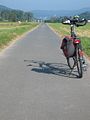
Beginning of the cycle path in Lahnhof
Between Cölbe and Biedenkopf in the direction of Biedenkopf
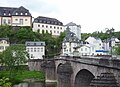
Weilburg:
Stone Lahn Bridge with a castle on the top left
_on_East_bank,_ice_in_January_on_frozen_river_Lahn_and_old_town,_2017-01-24.jpg)


See also
literature
- bikeline Radtourenbuch Lahntal-Radweg - From the source to the Rhine. 1: 50: 000.9., Revised edition. Verlag Esterbauer, 2010, ISBN 978-3-85000-105-2
- Uwe and Christiane Ziebold: Lahntal cycle path . Bruckmann-Verlag, Munich 2010, ISBN 978-3-7654-5196-6
- Cycling map of the Lahntal cycle path, 1: 50,000. Publicpress-Verlag, ISBN 978-3-89920-301-1
- Lahn Valley Cycle Path - 19 daily stages with maps 1: 75,000. Verlag Bruckmann, 2010, ISBN 978-3-7654-5196-6
- Lahn valley cycle path. From the Rothaar Mountains to Rhineland-Palatinate . ADFC compact spiral. BVA Bielefelder Verlag, 2013, ISBN 978-3-87073-585-2
Web links
- Radreise-Wiki Lahn Directions with distance information
- Cycling in the Lahntal at Lahntal Tourismus Verband e. V.
- Lahntalradweg In: Cycle Route Planner Hessen
Individual evidence
- ↑ a b The Lahn is fun on adfc-radtourismus.de, accessed on March 26, 2018
- ^ Lahntalradweg ( memento from March 26, 2018 in the Internet Archive ), on adfc-tourenportal.de, accessed on March 26, 2018
- ↑ ADFC quality cycle routes with 4 stars ( memento from August 25, 2018 in the Internet Archive ), on adfc.de, accessed on March 25, 2018
- ↑ The ADFC bicycle travel analysis 2009 ( Memento from August 11, 2018 in the Internet Archive ) on adfc.de, accessed on March 26, 2018
- ↑ Lahntalradweg receives four stars on siegener-zeitung.de from March 20, 2017, accessed on March 26, 2018
- ↑ Lahntalradweg In: Radroutenplaner Hessen. Accessed October 2018
- ↑ The expansion of the Geilnau-Laurenburg section and thus the long-required closing of the gap directly on the river is to be funded by the economic development agency with an amount of up to one million euros. The BUND has brought an action against the planning approval of December 2009. The planning approval was canceled by the administrative court and on April 9, 2011 by the higher administrative court (file number: 1 A 11088 / 10.OVG) Koblenz: OVG Rhineland-Palatinate . In February 2011 the citizens' initiative Pro Lückenschluss Lahntalradweg was founded. Your goal is to close the last gap in the Lahntal cycle path between Laurenburg and Geilnau. The old towpath has already been made provisionally usable by volunteers: Citizens' initiative Pro Gap Closure Lahntalradweg .
- ↑ Closure of the Weidenhausen Bridge - Detour to the goal ( memento from February 27, 2018 in the Internet Archive ), Oberhessische Presse, February 25, 2018.
Coordinates: 50 ° 28 '25.6 " N , 8 ° 15' 49.9" E