
Siegtal cycle path
| Siegtal cycle path | |||||
|---|---|---|---|---|---|
 |
|||||
| overall length | 162 km; - 119 km: North Rhine-Westphalia; - 43 km: Rhineland-Palatinate |
||||
| location |
|
||||
| Starting point |
Victory source 50 ° 55 ′ 5.3 " N , 8 ° 14 ′ 46.2" E |
||||
| Target point | The mouth of the Sieg near Bonn 50 ° 46 ′ 5.6 " N , 7 ° 4 ′ 37.1" E |
||||
| Places along the way | (Source of victory)
(Victory mouth) |
||||
| Connection to | Rhine Cycle Path , Lahntal Cycle Path , Eder Cycle Path , Ruhr-Sieg Cycle Path | ||||
| Website URL | Sieg Cycle Path (Siegtal Cycle Path) | ||||
The Siegtal-Radweg , also called Radweg Sieg , is a 162 km long long- distance cycle path along the Sieg . 119 km of its route are in North Rhine-Westphalia and 43 km in Rhineland-Palatinate . The cycle path runs from the Siegquelle to the Sieg estuary .
course
The Siegtal Cycle Path runs from the Siegquelle , located in the Rothaar Mountains and the Sauerland-Rothaar Mountains Nature Park - in North Rhine-Westphalia and Rhineland-Palatinate - through Siegen in a westerly direction and ends north of Bonn at the mouth of the Sieg .
Path quality
The Siegtal cycle path runs mainly on paved paths and roads, in the upper area there are also a few short unpaved sections. There the busy road through the Siegtal is practically always within earshot. Most of the route runs on cycle paths that accompany the road, although the quality in terms of path width and surface quality can sometimes be classified as poor. In the middle section of the Sieg between Siegen and Rosbach , the Siegtalroute often follows the federal roads 62 and 256 , although there is often no cycle path. The signage for the cycle path is also very sketchy, especially in this section.
Therefore, the following recommendation is currently being made: “Due to the poor quality of the Siegradweg in the Altenkirchen district , Rhineland-Palatinate , a family-friendly long-distance cycle path is not available in this section until further notice. This expansion will take a few more years due to a lack of resources. The current route often runs directly on the busy federal road 62 and is too dangerous. Those responsible in the state, district and municipalities are working hard to establish a continuous connection. But this will take a few years. ”Currently (as of June 10, 2020) one assumes that the total gap will be closed in 2024, but this cannot be verified in concrete terms, as different authorities work differently and the topography, such as between Fürthen and Etzbach and knowledge (victory) does not allow for faster planning.
The Siegtal widens towards the confluence with the Rhine, so that the cycle path partly leaves the road here. From Rosbach there is a beautiful combined foot / bike path to behind Schladern . From Dattenfeld , the cycle path is almost continuous to the mouth of the Sieg (59.3 km). There is only one interruption in Lützgenauel . Between Merten and Auel , the path follows the railway embankment and crosses the Sieg on a cycle path at the railway bridge, which was built as part of the Regionale 2010 . From Hennef you drive partly on the Siegdamm on good quality paths (partly asphalt, partly fine gravel) to the mouth of the Sieg. The path is only interrupted by short stretches of road when crossing cities.
Siegtal pure
Every year on the first weekend in July, the Siegtal Pur event , a car-free Sunday for the benefit of cyclists and inline skaters, takes place from the Siegquelle to the mouth of the Sieg . During the course of the day of the event, the timetable on the parallel victory route will be increased and additional trains with several baggage cars will be deployed between Betzdorf and Siegburg (marked as RE9- Rhein-Sieg-Express ) and between Wissen and Cologne-Ehrenfeld (marked as S12 ), such as on July 3, 2016.
Attractions
- Freusburg
- Ruins of Windeck Castle
- Siegfall at Schladern
- Siegtaldom in Dattenfeld
- Thing place in Herchen
- Merten Monastery
- City of Blankenberg
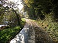
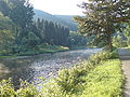
photos
- Pictures of the Siegtalradweg
From Dreisel towards Dattenfeld
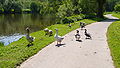
Geese at Schladern
Behind data field

To data field

Steps at Bülgenauel

Siegdamm at Müllekoven


Further bike paths afterwards
- Rhine Cycle Path (1230 kilometers, connection below the Beuel district of Bonn )
- Lahntal cycle path (from the Siegquelle approx. 2.5 km south to the Lahn spring, 245 km to the confluence with the Rhine at Lahnstein)
- In Kirchen there is a connection via the Ruhr-Sieg cycle path to Meschede to the Ruhr valley cycle path (113 km).
See also
Web links
- Course of the section from Hamm (Sieg) to Mondorf (Niederkassel) (openstreetmap), on familie-ammel.de
- Download the section Hamm-Mondorf as a GPX file for navigation devices from familie-ammel.de
- A bike tour along the Sieg in the General-Anzeiger Bonn is so idyllic . Retrieved April 13, 2020
Individual evidence
- ↑ a b c Radweg Sieg ( Memento of the original from July 3, 2016 in the Internet Archive ) Info: The archive link has been inserted automatically and has not yet been checked. Please check the original and archive link according to the instructions and then remove this notice. , on radroutenplaner.nrw.de
- ↑ Sieg Cycle Path - Experience the River Landscape at naturregion-sieg.de
- ↑ Sieg cycle path> cycle path , on naturregion-sieg.de
- ↑ Sieg-Radweg is still waiting for completion in AK-Land , on ak-kurier.de from June 10, 2020, accessed on June 10, 2020
- ↑ Siegtal Pur… Car-free Siegtal , on naturregion-sieg.de
- ↑ Additional timetable Siegtal Pur 2016 , on commons.wikimedia.org
- ↑ Panorama cycle paths (Naturarena Bergisches Land), accessed on July 4, 2016, from dasbergische.de