Schladern
|
Schladern
community Windeck
Coordinates: 50 ° 48 ′ 32 " N , 7 ° 35 ′ 25" E
|
|
|---|---|
| Height : | 110-180 m above sea level NHN |
| Residents : | 1128 (Dec. 31, 2013) |
| Postal code : | 51570 |
| Area code : | 02292 |
|
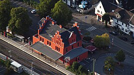
The train station in Schladern (2013), after the renovation
|
|
Schladern is part of the municipality of Windeck . The place arose from Hof Schladern , the oldest building in the place, which belonged to Ehrenstein Monastery from 1461 to 1812 .
location
Schladern is below the 296 m high ground Bergs at a height of 110- 180 m above sea level. NHN on the edge of the Bergisches Land . In addition, Schladern is directly north of the Sieg . This forms the victory case here . To the west of Schladern lies Altwindeck , to the north the hamlets of Jucht, Höhnrath and, far away, Hahnenbach and the Ommeroth estate. East of Schladern the Westertbach flows into the Sieg. The village of Mauel is on the south bank of the Sieg .
history
In 1863, Celtic rainbow bowls were found in Schladern .
After Napoleon dissolved the ecclesiastical possessions, estates and monasteries in the Rhineland in 1803, the Schladern farm, which belonged to the Ehrenstein monastery in the Wiedtal, was also sold along with its lands. Three families bought the land and built the first houses in the upper and lower courtyards. With the construction of the Deutz-Gießener Railway from Deutz to Gießen, land was sold to the railway. Furthermore, workers and employees of the railway came to Schladern and the place experienced an enormous boom and population growth. The construction of the railway saves a tunnel on the Schloßberg in the west of the village by blasting a deep cut for the railway line, today's so-called Porta Rhenania . Furthermore, the ridge between the Auelsberg and the Steinerberg was blown up and so the Siegfall was created . This shortened the Siegbogen around the Krummauel and the railway could save two bridges. The course of victory was completely changed in this way. Hof Stein fell victim to the railway construction and the residents had to leave their homes. From 1860 the Schladern train station was opened, the architectural style of which was adapted to the former Windeck Castle. Until 1932 Schladern belonged to the Waldbröl district, then to the Siegkreis. On May 14, 1964 a US fighter aircraft of the type McDonnell F-101 C Voodoo crashed in the Bodenberg area, in the direction of Höhnrath . The cause of the crash was a disorientation of the pilot due to the failure of the compass. Nobody was harmed in the accident.
Residents
In 1885, 23 houses with 162 inhabitants belonged to Schladern.
religion
The Catholic Church of St. Elisabeth was built from 1928 to 1929 and is named after St. Elisabeth of Thuringia .
The Evangelical Peace Church in Schladern was built in 1951 by the Evangelical Church Building Association Schladern eV and has been maintained by them ever since. In 1959 a bell tower was added. From 1988 to 1996, stained-glass windows with leaded glass were fitted to the design by the pastor and sculptor Werner Erdmann (* 1935). In 2011 the church received a bronze altar sculpture by the same artist.
Forest cemetery
The Schladern forest cemetery is run by the Schladern cemetery association. V. looks after on its own responsibility. The cemetery was laid out in the 1920s on a forest plot above Schladern and gradually expanded in the following decades. In addition to traditional coffin and urn burials, burials in the root area of trees are also possible in the cemetery.
traffic
Schladern is located on the main road 333. The station Schladern (win) is a breakpoint of S 12, S 19 and the Rhein-Sieg-Express (RE 9) on the win range , Aachen over Cologne and Siegen.
Hiking trails
The hiking trail X28, the so-called Graf-Engelbert-Weg , a main hiking route of the Sauerland Mountain Association, ends or begins in Schladern . This 111 km long hiking trail begins in Hattingen and ends at Schladern train station.
Above the village of Schladern there is another supraregional hiking trail, the 141 km long Sieghöhenweg from the Siegquelle to the mouth of the Sieg.
There are also various local hiking trails that u. a. lead to Windeck Castle and Siegfall .
Schools / kindergarten
Schladern originally had two identically constructed denominational elementary schools that were built in 1905: the Protestant and the Catholic school. At the moment only the building of the former Protestant school is standing; This is where the community kindergarten is located today. The Catholic primary school was closed on December 1, 1966.
Today there is the Bodenberg elementary school in Schladern; the original building dates from the 1960s.
Industry
At the end of the 19th century, the British Elmore's Patent Copper Depositing Company founded a factory for the production of copper tubes at Siegfall. In 1966, the Elmore's factory was leased to the cable and metal works Gutehoffnungshütte AG ("Kabelmetal", today KM Europa Metal ) from Hanover, which took it over in 1969. In 1995 production in Schladern was stopped and the factory closed.
After the site had been an industrial wasteland for a long time, a community and cultural center has now been established there in cooperation with the Windeck Community Foundation, the Windeck community and the Energiepark am Wasserfall GmbH.
Web links
Individual evidence
- ↑ Windeck - List of localities , accessed on April 3, 2014.
- ↑ http://forgottenjets.warbirdsresourcegroup.org/F-101.html
- ^ Community encyclopedia for the Kingdom of Prussia from 1885.
- ↑ Schladern cemetery association V.
- ^ Rhein-Sieg-Rundschau v. April 20, 1966
- ^ Website of the Windeck Citizens' Culture Center (kabelmetal) .


