
Hoppengarten
|
Hoppengarten
community Windeck
Coordinates: 50 ° 47 ′ 59 ″ N , 7 ° 31 ′ 30 ″ E
|
|
|---|---|
| Height : | approx. 104 m above sea level NHN |
| Residents : | 281 (March 31, 2019) |
| Postal code : | 51570 |
| Area code : | 02292 |
 Sankt-Michaels-Kapelle Hoppengarten
|
|
Hoppengarten is a place in the municipality of Windeck in the Rhein-Sieg district . Hoppengarten is affected by the state road 333 and intersected by the railway with the high-lying Siegtal route .
location
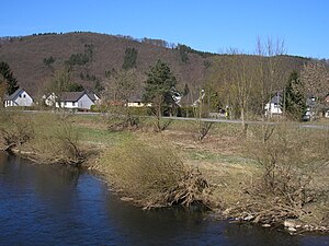
Hoppengarten is located on the northern right bank of the Sieg and is geographically part of the Bergisches Land and Nutscheid . Neighboring towns are Kaltbachmühle and Röcklingen in the west and Rossel with Wilberhofen in the east.
history
In 1885 Hoppengarten consisted of forty houses and had 194 inhabitants. The associated Hof Wilhelmshöhe had a house with seven residents. On September 15, 2019, the village on the Sieg celebrated its 500th anniversary.

Hoppengarten, above the bridge
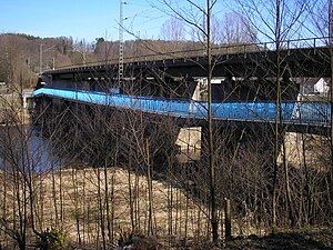
Railway and cycle path bridge in Hoppengarten
Hoppengarten, below the bridge


Individual evidence
- ↑ List of localities. Windeck, accessed on May 11, 2020 .
- ^ Community encyclopedia for the Kingdom of Prussia . Volume XII. Rhineland Province. Publishing house of the Royal Statistical Bureau, Berlin 1888, p. 111 ( digitized version [PDF; 1.5 MB ; accessed on May 11, 2020]).
- ↑ 500 years of Hoppengarten. Tourism Windecker Ländchen e. V., accessed on May 11, 2020 .

Alsen | Altenherfen | Altwindeck | Au | Bellingen | Data field | Distelshausen | Dreisel | Ehrenhausen | Calibration | Owl Break | Geilhausen | Torn | Gierzhagen | Gutmannseichen | Hahnenbach | Halscheid | Hau | Helpenstell | Herchen | Herchen train station | Himmeroth | Hönrath | Hoppengarten | Hurst | Imhausen | Irsen | Kaltbachmühle | Kocherscheid | Kohlberg | Kuchhausen | Langenberg | Leidhecke | Leuscheid | Lure depths | Löh | Lüttershausen | Mauel | Mauelermühle | Means | Neuenhof | Upper room | Öttershagen | Ohmbach | Ommeroth | Opperzau | Persoap | Rieferath | Ring sites | Rossel | Röcklingen | Röhrigshof | Rommen | Rosbach | Roth at Rossel | Hall | Sangerhof | Joke | Schladern | Sommerhof | Stromberg | Unkelmühle | Throw | Werfermühle | Wiedenhof | Wilberhofen | Wilhelmshöhe