Source of victory
| Source of victory | |||
|---|---|---|---|
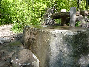
 The water extraction point of the Siegquelle (May 2014) |
|||
| location | |||
| Country or region | Jägerhain , Rothaargebirge , Siegen-Wittgenstein District , North Rhine-Westphalia ( Germany ) | ||
| Coordinates | 50 ° 55 ′ 5 " N , 8 ° 14 ′ 47" E | ||
| height | 603 m above sea level NHN | ||
|
|||
| geology | |||
| Mountains | Rothaar Mountains | ||
| Source type | Flow source | ||
| Exit type | Layer source | ||
| Hydrology | |||
| River system | Rhine | ||
| Receiving waters | Victory → Rhine → North Sea | ||
Coordinates: 50 ° 55 ′ 5 " N , 8 ° 14 ′ 47" E
The Siegquelle near Walpersdorf in the North Rhine-Westphalian district of Siegen-Wittgenstein ( Germany ), is the source of the 155.2 km long Sieg River in the Rothaargebirge , which flows into the Rhine at the Mondorf district of Niederkassel .
geography
location
The Siegquelle is located in Westphalia in the (historical) Siegerland in the southern part of the Rothaargebirge . It is located in the Sauerland-Rothaargebirge nature park around 3.5 km northeast of Walpersdorf , a district of Netphen , and around 575 m (as the crow flies ) west of Großenbach , one of Bad Laasphe ; about 350 m east of the at about 603 m above sea level. NHN lying source runs the border of both cities. In a south-easterly direction, the wooded landscape rises to the approx. 400 m distant summit of a 650.7 m high elevation in the Jägerhain parcel (formerly also called Sauspitze or Sonnenspitze). About 1 km (as the crow flies) north-west of the source rises the Aukopf ( 644.9 m ), at the south-west foot of which not only one of the uppermost tributaries of the Sieg, the Ahornbach, rises, but also where the watershed of Sieg, Lahn and Eder meet. The Lahn spring (Lahntopf) and the Eder and Ilm springs are within a few kilometers .
Natural allocation
The Siegquelle belongs to the natural spatial main unit group Süderbergland (No. 33), in the main unit Rothaargebirge (with Hochsauerland ) (333) and in the subunit Dill-Lahn-Eder source area (333.0) to the natural area Ederkopf-Lahnkopf-Ridge (333.01).
Protected areas
The Siegquelle is located in the landscape protection area of the community of Netphen ( CDDA no. 321048; designated 1987; 117.6 km² in size). The fauna-flora-habitat area Rothaarkamm and Wiesentäler (FFH no. 5015-301; 34.46 km²) extends west of the source region .
history
In the oldest written document about the course of the border between Siegen and Wittgenstein, the Siegquelle is referred to as Potzenn (it was only after scientific research that it was found out that Potzenn can be equated with Siegquelle ). On September 22, 1515, the source was mentioned in a comparison between Siegen and Wittgenstein as Siegenputz . In 1630 the name Seepfützen followed and in 1671 Siegpfützen .
In the oldest surviving view of the Siegquelle from 1849, it is shown as a contained spring, covered with a pointed roof supported on beams . Above the spring you can see a small house, which was called the Sieghäuschen. From the early 1920s, when a new version was created, until late summer 1959, spring water gushed out of a concrete pipe in a stone wall. The spring, which was enclosed in a new wall, was presented to the public with a ceremony on July 10, 1960. In the spring of 1966, however, this wall collapsed because there was no concrete wall behind the broken stones.
Therefore, a new wall was built in August 1966. Finally, the source was renatured in spring 2013. (see section Renaturation ... ) The Siegquelle hikers' car park was created in the summer of 1965.
Source or headwaters
The Siegquelle is actually not just a source, but an entire source area - near the Eisenstrasse of the Rothaargebirge . It is a layer source and arises from a source horizon . In the forest around a longer wooden plank path, individual dammed water holes can be seen in the source area. The main outlet of the spring is just above another, shorter wooden boardwalk. In addition, there is a spring above the stone cuboid with a hollow as a water extraction point (see photo) and several area springs in the forest area between the Siegquelle hiker's car park and the road to Großenbach.
The captured Siegquelle had a spring discharge of two liters per minute until 2013. This was probably due to the fact that most of the spring water oozed out of the earth next to the wall. On the other hand, there are measurements from 1960 to 1967. In these years the spring discharge averaged 1.1 liters per second. The extreme results of this series of measurements were measured on October 13, 1960 at 5 liters per second and on May 22, 1967 at around 0.14 liters per second. The Siegquelle has an average water temperature of 11.6 ° C.
Water quality
In August 1960, a chemical and bacteriological investigation of the Siegquelle was carried out by the Siegen Chemical Investigation Office. In a report from September 9, 1960, it finally states that the water from the Siegquelle is very soft and manganese-free water that only contains small amounts of iron. The bacteriological findings classified the Sieg spring water as still relatively pure spring water.
Renaturation and tourist development 2013–2014
Source area
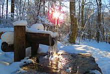
In early 2013, the Siegquelle was renatured as part of the QuellenReich project . The old enclosure wall - with the letters Siegquelle and, a little further to the right, 603 m - made of rubble stones was demolished. A little further away from the renatured (main) spring, a wooden channel supported on wooden piles and open at the top discharges water from a smaller secondary spring, which falls into a hollow on a stone block at the end of the channel and then flows off through the Sieg.
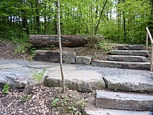
Because the spring visitors should not walk on the forest floor into the spring area, a wooden plank path was laid there. In addition, the creek passage below the Eisenstrasse was enlarged and a connection to the Kerbbachtal was created. A new staircase with natural stone steps on the embankment of the road to Großenbach was also built. A tree trunk is deposited above a small plateau (roughly in the middle of the stairs), in which the above-mentioned letters from the old enclosure wall are embedded. In addition, new trees were planted in the area around the Siegquelle. In addition, the Siegquelle hikers' car park is to be partially paved so that tourists can enjoy a pleasant visit. A connection between the new path and the Siegquelle forest adventure trail was also implemented.
The official opening ceremony of the "new" Siegquelle took place on May 10, 2014.
Nature trails
Sieg Quellenrundweg
By the end of 2013, new educational trails on wooden planks had been laid out in the Siegquelle region . On signs that have been set up along the boardwalk since spring 2014, the graphic mascot Bythinella , a spring snail , explains the special features of the spring area in a playful way. From the Siegquelle hikers' car park , such a path leads through a small wooded area and reaches the (new) water supply point on the other side of Großenbacher Straße , after several steps and a small stretch of path. From there the path runs through the main spring area, and after crossing the iron road it leads down the slope for a while. Finally he meets the forest adventure trail . This can be followed in two directions. One leads back to the parking lot on a section of the forest adventure trail (and at the same time on a section of the Sieg Quellenrundweg ). The Sieg Quellenrundweg is approx. 300 meters long.
Siegquelle forest adventure trail
The Siegquelle Forest Adventure Trail is a larger circular trail with a length of 1.5 km. It begins on Eisenstrasse, opposite the Siegquelle hikers' car park . From there it leads into the forest and a little later crosses a small tributary of the Sieg. Shortly afterwards, the Sieg itself is crossed. A little further on there is a sound station where you can try out the sounds of different tree species with tonewoods. This is followed by the jungle path, a narrow path that leads between young beeches. This is followed by the green classroom station , where there are several benches and another seat on a tree stump. From there you continue, roughly in an easterly direction, and after a short time you cross a small stream over a tree trunk. A little further on, another stream is crossed over a board. At the next station there is a metal telescope (without lenses) that you can use to search for the animals in the forest. Then the path leads steeply uphill for a while. Once at the top, he roughly turns west and after a short time comes to the Quellebrille station , where you can gain an insight into the Quelle habitat. A little further follows the bark sensor station , where you can feel different types of bark and then, without seeing which ones, you can guess which tree species have been detected. After the path has crossed a clearing, you can climb a small viewing platform. Then it leads steeply down into a small gorge. Once at the bottom you will find yourself at the Siegquelle quarry . From there it is only a few meters to walk through the forest until you reach the Siegquelle. You can return to the parking lot via the Sieg Quellenrundweg .
Roads and trails
The Eisenstrasse of the Rothaargebirge ( Landesstrasse 722; Lützel - Lahnhof ) runs a few meters west of the Siegquelle and crosses the L 719 (Großenbach-Walpersdorf) 170 meters further northwest at an altitude of 596.2 m . There is a parking lot less than 100 m east of the intersection. The Rothaarsteig leads directly past the source . In the future, the source is also to be connected to the Natursteig Sieg .
Say about the giant
A legend that has to do with the source of victory says that an ancient giant once lived there. He lived on the goods of the forest and spared the surrounding villages as long as their inhabitants left him in peace. One day, however, a great drought and famine broke out. Only clear water still gushed from the giant's spring. That is why the inhabitants of the villages are said to have gone to the giant and asked him for food and water. The giant, however, turned anyone who entered his forest castle into a tree, and none of the residents who had gone to the giant was ever seen again.
Special postage stamp
As part of the city festival for the 775th anniversary of Netphen , a special stamp was issued showing the new water supply point at the Siegquelle.
literature
- Gerhard Scholl: In the headwaters of Sieg and Lahn .
- Adventure hiking guide Rothaarsteig. 6th edition. Rothaarsteigverein, Schmallenberg 2014, ISBN 978-3-9809857-6-5 .
- Hermann Böttger, Wilhelm Weyer, Alfred Lück: History of the Netpherland . 1967.
Web links
- quellenatlas.eu , European Source Atlas
Individual evidence
- ↑ a b c Topographical Information Management, Cologne District Government, Department GEObasis NRW ( information )
- ↑ Map services of the Federal Agency for Nature Conservation ( information )
- ↑ a b Gerhard Scholl: In the headwaters of Sieg and Lahn: on the history of the eastern Siegerland. Zimmermann, Balve iW 1961, DNB 780131894 .
- ↑ a b European Source Atlas


