Lennequelle
| Lennequelle | |||
|---|---|---|---|
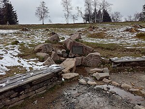
 The Lenne spring with a metal panel, drain and bench seats on both sides |
|||
| location | |||
| Country or region | Kahler Asten , Rothaar Mountains , Hochsauerlandkreis , North Rhine-Westphalia ( Germany ) | ||
| Coordinates | 51 ° 10 ′ 47 " N , 8 ° 29 ′ 4" E | ||
| height | 825 m above sea level NHN | ||
|
|||
| geology | |||
| Mountains | Rothaar Mountains | ||
| Source type | Flow source | ||
| Exit type | Hill debris source | ||
| Hydrology | |||
| River system | Rhine | ||
| Receiving waters | Lenne → Ruhr → Rhine → North Sea | ||
Coordinates: 51 ° 10 ′ 47 " N , 8 ° 29 ′ 4" E
The Lenne source in the Rothaargebirge is the close of the Winterberg main town on the Kahler Asten in Westphalia North Rhine- Hochsauerlandkreis ( Germany ) lying source of the 129 km long Lenne , in the outer north of the Ruhr town of Hagen in the Ruhr flows. With its altitude at 825 m above sea level. NHN it is the highest spring in northwest Germany.
geography
location
The Lenne spring is located in the northern part of the Rothaargebirge in the Westphalian Sauerland . It rises near the summit of the 841.9 m high Kahler Asten and about 315 m west of the Astenturm observation tower at 825 m height. In the Sauerland-Rothaargebirge nature park , it is located around 3.6 km (as the crow flies ) southwest of the city center of Winterberg , in whose district it is, 1.6 km southeast of Altastenberg and 1.1 km north-northeast of Lenneplätze , both of which belong to Winterberg . The Lenne, which rises there, initially flows steeply down the valley towards Westfeld , a district of Schmallenberg .
The Rothaarsteig long-distance hiking trail runs directly south past the Lenne spring . In their surroundings and on the summit region of the Kahler Asten there are other paths, including the Kahler Asten educational trail, which passes through the high heath of the mountain and the spring .
Natural allocation
The Lennequelle belongs to the natural spatial main unit group Süderbergland (No. 33) in the main unit Rothaargebirge (with Hochsauerland ) (333) and in the subunit Winterberger Hochland (333.5) to the natural area Astenturm (333.54).
Rhine-Weser watershed
The Lenne spring is close to the Rhine-Weser watershed that runs over the Kahler Asten . While the water of the Odeborn , which rises on the south-eastern slope of the mountain, flows through the Eder and Fulda to the north-east of the Weser , that of the Lenne spring, which rises on the south-western slope of the mountain near the summit, runs west through the Lenne and Ruhr into the Rhine .
Protected areas
The spring of the Lenne is located in the nature reserve (NSG) Kahler Asten (Winterberg) ( CDDA no. 82021), which was (last) designated in 2008 with 48.6 hectares . The NSG Kahler Asten (Schmallenberg) (CDDA no. 389798, 2008; 1.23 ha) is located a few meters south-east of the source, roughly at its altitude . In addition, a few meters southwest below the source along the Lenne lies the Upper Lennetal NSG (LP Schmallenberg) (CDDA no. 389846; 2008; 25.58 ha), to which the Upper Lennetal NSG (LP Winterberg ) (CDDA- No. 389847; 2006; 6.33 ha) follows. The source is also located in the FFH area Kahler Asten (FFH no. 4816-303; 52.99 ha). Landscape protection areas close to the source are: Schmallenberg SO (CDDA no. 555555146; 2005; 112.9385 km² ) and the Kahler Asten ski area (type C; CDDA no. 386344; 2005; 4.63 ha).
Source and water supply
The Lenne spring is a source of disturbance (border between the Asten strata and the Upper Fredeburg strata ), but compared to other disturbance sources in the Rothaargebirge (such as the Somborn spring , Ilsequelle ) it has a very weak bed. This is partly due to the small catchment area , as the Asten summit is only a few hundred meters away. In hot summer months, the spring can temporarily dry up and therefore be referred to as an intermittent spring.
The spring water gushes out of a hidden drainage pipe between several large, artificially deposited chunks of quartz keratophyrus. There are benches next to the spring, between which the water runs down between small boulders.
A metal plaque with the inscription: "LENNEQUELLE - 830 m above sea level - length of the river 138 km" was attached to the water outlet of the spring . Both values mentioned, height and length, differ from the information given in the German basic map and in water station maps ( 825 m and 129 km). The 830 m height line runs about 55 m northeast of the source.
Web links
References and comments
- ↑ a b c Topographical Information Management, Cologne District Government, Department GEObasis NRW ( information )
- ↑ Martin Bürgener: Geographical Land Survey: The natural spatial units on sheet 111 Arolsen. Federal Institute for Regional Studies, Bad Godesberg 1963. → Online map (PDF; 4.1 MB)
- ↑ Detailed information and individual references to protected areas of the Lennequelle region: see section Protected areas of the article Kahler Asten
- ↑ Flyer: GeoWanderführer Rothaarsteig ( memento of the original from September 24, 2015 in the Internet Archive ) Info: The archive link has been inserted automatically and has not yet been checked. Please check the original and archive link according to the instructions and then remove this notice. , Geological Service NRW, 216 S., Krefeld, 2008, ISBN 978-3-86029-973-9 (PDF; 2.51 MB)


