Ilsequelle
| Ilsequelle | |||
|---|---|---|---|
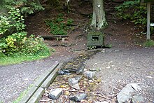
 Spring version of the Ilsequelle (summer 2013) |
|||
| location | |||
| Country or region | Compass , Rothaar Mountains , Siegen-Wittgenstein District , North Rhine-Westphalia ( Germany ) | ||
| Coordinates | 50 ° 53 ′ 8 " N , 8 ° 16 ′ 48" E | ||
| height | 608 m above sea level NHN | ||
|
|||
| geology | |||
| Mountains | Rothaar Mountains | ||
| Source type | Flow source | ||
| Exit type | Source of interference | ||
| Hydrology | |||
| River system | Rhine | ||
| Receiving waters | Ilse → Lahn → Rhine → North Sea | ||
Coordinates: 50 ° 53 ′ 8 ″ N , 8 ° 16 ′ 48 ″ E
Ilse source stands for the two in the Rothaargebirge underlying sources of Lahn -Nebenflusses Ilse . They are located near Heiligenborn in the Siegen-Wittgenstein district in North Rhine-Westphalia . There is the uppermost Ilsequelle, to which the brook kilometrage of the 8.7 km long Ilse refers, and the Holy Ilsequelle , which is located somewhat downstream .
Geographical location
The two Ilsequellen are each in the south of the Rothaargebirge, Sauerland-Rothaargebirge Nature Park and Westphalia near the central Hessian border.
Supreme Ilsequelle
The top spring is located on the border of Wittgensteiner Land and Siegerland about 700 m south-southeast of the hamlet of Heiligenborn , a south-western district of Bad Laasphe . It flows from the east-northeast flank of the Jagdberg ( 675.9 m above sea level ) at about 636 m ( ⊙ ) altitude; its summit is 570 m from the source.
Holy Ilsequelle
Viewed from the uppermost spring, the holy Ilsequelle ( ⊙ ) is located around 0.5 kilometers downstream . It is located about 2.1 km southwest of Bernshausen , 3.2 km east of the Lahnhof exclave belonging to Nenkersdorf and 1 km (as the crow flies) south of Heiligenborn. This spring is located in a small meadow valley surrounded by forest and flows from a height of 608.2 m from the northwest slope of the Kompass mountain , which, at 694.1 m, is the highest point in the Bad Laaspher urban area; its summit is 250 m away from the source.
A few meters below the Holy Ilsequelle is a small pond . There are seven other small source streams that have their origin near the top stream source in a swamp area. The source is a source of interference.
history
The lower source of the Ilse was already known as Heilige Ilsequelle in the Middle Ages and was one of the most famous medicinal springs in Central Europe. Sick people made a pilgrimage there to find relief by drinking spring water from a drinking fountain and bathing in the artificially created bathing pond . In today's currency, the income from alms in 1622 amounted to around 22,000 euros in just 10 days. The subsequent plague wave of 1625 and the Thirty Years War (1618–1648) ended the pilgrimage to Ilsequelle for the time being and it was forgotten. However, after a woman who had been suffering from gout for years and could hardly walk was healed by a six-week drinking cure in 1862, many people made the pilgrimage to the spring for a while.
Of the bathing facilities built at that time, the source enclosure from the 17th century, which was carried to Laaspherhütte in the 19th century , and the bathing pond have been preserved. In the meantime, this had been converted into a fish pond, which is why it had to be renatured again. The piping of the Ilse, through which it was temporarily routed, also had to be torn down. It was replaced by a new ford through which the hiking trails mentioned below run. The entire course of the Ilse is thus biologically intact again. For some years now, there have been benches , deck chairs and tables at the source , as well as an information board about the history of the Ilsequelle.
Traffic and walking
The closest street is Kreisstraße 17, which branches off a little south of the Lahnhof from the Eisenstraße des Rothaargebirge ( L 722 ) and then leads through the nearby hamlet of Heiligenborn and past Lindenfeld to Banfe . The European long-distance hiking trail E1 , the Rothaarsteig , the Lahn hiking trail and the fairy tale hiking trail Kleiner Rothaar lead past the Holy Ilsequelle . A few hundred meters away from these paths is the uppermost Ilsequelle.

