Ruhr spring
| Ruhr spring | |||
|---|---|---|---|
 Ruhrquelle (2010) |
|||
| location | |||
| Country or region | Ruhrkopf , Hochsauerlandkreis , North Rhine-Westphalia ( Germany ) | ||
| Coordinates | 51 ° 12 ′ 48 " N , 8 ° 33 ′ 28" E | ||
| height | 674 m above sea level NHN | ||
|
|||
| geology | |||
| Mountains | Rothaar Mountains | ||
| Source type | Flow source | ||
| Exit type | Hill debris source | ||
| Hydrology | |||
| River system | Rhine | ||
| Receiving waters | Dysentery | ||
Coordinates: 51 ° 12 ′ 48 ″ N , 8 ° 33 ′ 28 ″ E
The Ruhrquelle in the Rothaargebirge is the source of the Ruhr , a 219.3 kilometer long right-hand tributary of the Rhine , located in the Hochsauerlandkreis , North Rhine-Westphalia .
geography
location
The Ruhrquelle lies in the northeast of the Rothaargebirge in the Hochsauerland . It is located in the Sauerland-Rothaargebirge nature park about 3 km northeast of the Winterberger core town on the northeast slope of 695.7 m above sea level. NHN high Ruhrkopf at an altitude of 674 m . The villages closest to the source, which both belong to Winterberg, are Grönebach, 1.8 km to the north, and Elkeringhausen, 1.5 km to the south-east, as the crow flies .
Rhine-Weser watershed
The elongated Rhine-Weser watershed runs south above the Ruhr source over the Ruhrkopf : While the Ruhr flows westwards and finally flows into the Rhine , the water of the short streams that arise on the south-eastern slope of the mountain runs through the Orke , Eder and Fulda ultimately north-east to the Weser .
Natural allocation
The Ruhrquelle belongs to the natural spatial main unit group Süderbergland (No. 33) in the main unit Rothaargebirge (with Hochsauerland ) (333) and in the subunit Winterberger Hochland (333.5) to the natural area Harfeld (Winterberger Hochmulde) (333.56).
Source description
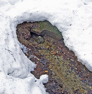
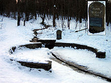
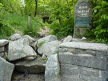
The Ruhr rises from a small, swampy area in the forest that is under nature protection. About 330 m (as the crow flies) northeast of the mountain summit and 7.5 m below the actual source of the Ruhr, at a height of 666.5 m, is a stone rondel ( ⊙ ) from the 1950s, on which a memorial stone was erected. According to the inscription and text on the metal plate below it, the stone reminds of the first construction of a wall in 1849 (at that time no roundabout) and of the centenary of 1949. The roundabout restored in 1980 turns the Ruhr water into a canal that is open to the top directed. The spring has an average discharge of 2500 liters per hour (this corresponds to about 0.7 liters per second). It is a source of debris.
The kilometering of the Ruhr refers neither to the actual Ruhr source nor to the aforementioned stone rondel, but to the source ( ⊙ ) of an approximately 200 m long tributary to the Ruhr. It begins around 180 m east-southeast of the roundabout at an altitude of 667 m , with a length of 219.3 km given as the Ruhr.
Renaturation measures
In 2006/2007 the Ruhrquelle and the first meters of its course were redesigned. The canalized brook received a naturally structured brook bed again, and dense bushes were thinned out to allow a good view of the small brook again. For visitors, footbridges have been created above the ground to visit the source region. In addition, the surrounding walls of the roundabout were renovated, paths for the natural development of the riparian vegetation were removed and new paths were laid a few meters away from the Ruhr to relieve the same.
Directions and hiking
The roundabout at the Ruhr source is on the on the west of the national road 480 leading branching and east to Kuestelberg national road 740 located Wanderparkplatz Ruhrquelle to achieve; there is a 200 m long footpath.
From the source to the confluence with the Rhine near Duisburg - Ruhrort , you can hike along the Ruhr on the Ruhrhöhenweg of the Sauerland Mountain Association or cycle on the RuhrtalRadweg ; Both trails start at the source, which the Küstelberg –Winterberg section of the Rothaarsteig leads past.
See also
Individual evidence
- ↑ a b c Topographical Information Management, Cologne District Government, Department GEObasis NRW ( information )
- ↑ Information board at the roundabout below the Ruhr spring
- ↑ Martin Bürgener: Geographical Land Survey: The natural spatial units on sheet 111 Arolsen. Federal Institute for Regional Studies, Bad Godesberg 1963. → Online map (PDF; 4.1 MB)
- ^ German basic map (DGK 5) in Topographical Information Management, Cologne District Government, Department GEObasis NRW ( information )
Web links
- Mirko Bonné: Very nice coquette bow. Once along the Ruhr.
- Description of all locations on this themed route as part of the Route of Industrial Culture
- Ruhrquelle on winterberg.de


